File:LithuanianHistory-ru.svg

Original file (SVG file, nominally 1,525 × 1,750 pixels, file size: 98 KB)
Captions
Captions
Summary
[edit]| DescriptionLithuanianHistory-ru.svg |
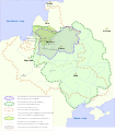
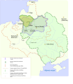
Русский: На карте отмечены территории Великого Княжества Литовского (ВКЛ), Речь Посполитая и Литовской Республики в разные исторические времена. А также територия Литовской Республики каторую признали Росия и Латвия 1920, и граница между Полъшей и ВКЛ до Люблинской унии 1569.
English: The map shows the territory of the Grand Duchy of Lithuania (GDL), The Polish–Lithuanian Commonwealth and The Republic of Lithuania in different historical times. Also in the map there are marked territories of Republic of Lithuania that were recognized by Latvia and Russia in 1920 and a border between GDL and Poland before they formed Polish–Lithuanian Commonwealth 1569.
Lietuvių: Žemėlapyje pažymėtos Lietuvos Didžiosio Kunigaikštystės, Lietuvos-Lenkijos valstybės ir Lietuvos Respublikos teritorijos skirtingais laikotarpiais. Taip pat pažymėta Lietuvos Respublikos teritorija kurią pripažino Latvija, Rusija 1920 m. ir siena tarp Lenkijos ir LDK prieš Liublino Unija 1569 m. |
|||
| Date | ||||
| Source |
|
|||
| Author | User:Knutux | |||
| Other versions |
[edit]
|
Licensing
[edit]| Public domainPublic domainfalsefalse |
| This work has been released into the public domain by its author, Knutux. This applies worldwide. In some countries this may not be legally possible; if so: |
File history
Click on a date/time to view the file as it appeared at that time.
| Date/Time | Thumbnail | Dimensions | User | Comment | |
|---|---|---|---|---|---|
| current | 17:35, 6 November 2019 |  | 1,525 × 1,750 (98 KB) | AlexWelens (talk | contribs) | Reverted to version as of 21:00, 11 July 2016 (UTC) |
| 16:11, 6 October 2016 |  | 512 × 588 (42 KB) | Michaelversatile (talk | contribs) | orphography | |
| 21:00, 11 July 2016 |  | 1,525 × 1,750 (98 KB) | Zair Probus (talk | contribs) | переносы | |
| 20:57, 11 July 2016 |  | 1,525 × 1,750 (98 KB) | Zair Probus (talk | contribs) | orpho | |
| 20:50, 11 July 2016 |  | 1,525 × 1,750 (98 KB) | Zair Probus (talk | contribs) | Переделал | |
| 09:57, 11 March 2015 |  | 1,525 × 1,750 (106 KB) | Vytautas.S (talk | contribs) | Changed orientation of text "Балтийское море" | |
| 20:01, 10 March 2015 |  | 1,627 × 1,867 (85 KB) | Vytautas.S (talk | contribs) | User created page with UploadWizard |
You cannot overwrite this file.
File usage on Commons
The following 12 pages use this file:
- File:Historia de Lituania.svg
- File:LihuanianHistory.ru.svg
- File:LithuanianHistory-PL.svg
- File:LithuanianHistory-es.svg
- File:LithuanianHistory-hr.svg
- File:LithuanianHistory-ru.svg
- File:LithuanianHistory.svg
- File:LithuanianHistory de.svg
- File:LithuanianHistory ro.svg
- File:LithuanianHistory sr.svg
- File:Lithuanian History-hu.svg
- Template:Other versions/Lithuanian history
File usage on other wikis
The following other wikis use this file:
- Usage on ru.wikipedia.org
- Usage on tt.wikipedia.org
Metadata
This file contains additional information such as Exif metadata which may have been added by the digital camera, scanner, or software program used to create or digitize it. If the file has been modified from its original state, some details such as the timestamp may not fully reflect those of the original file. The timestamp is only as accurate as the clock in the camera, and it may be completely wrong.
| Width | 1220pt |
|---|---|
| Height | 1400pt |


