File:Localización del Área Metropolitana de Granada.png
Jump to navigation
Jump to search
No higher resolution available.
Localización_del_Área_Metropolitana_de_Granada.png (529 × 435 pixels, file size: 24 KB, MIME type: image/png)
Captions
Captions
Add a one-line explanation of what this file represents
Summary
[edit]
| Description |
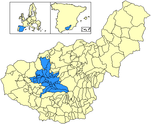
Situación del Área Metropolitana de Granada respecto a la provincia de Granada, en España. La forman los municipios de Albolote, Alfacar, Alhendín, Armilla, Atarfe, Cájar, Cenes de la Vega, Chauchina, Churriana de la Vega, Cijuela, Colomera, Cúllar Vega, Dílar, Fuente Vaqueros, Las Gabias, Gójar, Granada, Güevéjar, Huétor Vega, Jun, Láchar, Maracena, Monachil, Ogíjares, Peligros, Pinos Genil, Pinos Puente, Pulianas, Santa Fe, Valderrubio, Vegas del Genil, Villa de Otura, Víznar y La Zubia. |
| Date | 16 June 2007 (original upload date) |
| Source | No machine-readable source provided. Own work assumed (based on copyright claims). |
| Author | No machine-readable author provided. Satesclop assumed (based on copyright claims). |

|
File:Localización del Área Metropolitana de Granada.svg is a vector version of this file. It should be used in place of this PNG file when not inferior.
File:Localización del Área Metropolitana de Granada.png → File:Localización del Área Metropolitana de Granada.svg
For more information, see Help:SVG. |
 |
Licensing
[edit]
I, the copyright holder of this work, hereby publish it under the following licenses:

|
Permission is granted to copy, distribute and/or modify this document under the terms of the GNU Free Documentation License, Version 1.2 or any later version published by the Free Software Foundation; with no Invariant Sections, no Front-Cover Texts, and no Back-Cover Texts. A copy of the license is included in the section entitled GNU Free Documentation License. |
| This file is licensed under the Creative Commons Attribution-Share Alike 3.0 Unported license. | ||
| ||
| This licensing tag was added to this file as part of the GFDL licensing update. |
You may select the license of your choice.
File history
Click on a date/time to view the file as it appeared at that time.
| Date/Time | Thumbnail | Dimensions | User | Comment | |
|---|---|---|---|---|---|
| current | 14:54, 7 June 2014 | | 529 × 435 (24 KB) | Getxotarra~commonswiki (talk | contribs) | Los 34 municipios correctos (incluido Valderrubio) |
| 00:47, 28 July 2008 |  | 529 × 435 (24 KB) | Veggg (talk | contribs) | ||
| 21:31, 21 July 2008 |  | 529 × 435 (24 KB) | Veggg (talk | contribs) | ||
| 21:34, 1 December 2007 |  | 529 × 435 (21 KB) | Gabri (talk | contribs) | ||
| 16:28, 16 June 2007 |  | 372 × 306 (5 KB) | Satesclop (talk | contribs) |
You cannot overwrite this file.
File usage on Commons
The following page uses this file:
File usage on other wikis
The following other wikis use this file:
- Usage on en.wikipedia.org