File:Lyon. La Guillotière. Plan. 1710.jpg
Jump to navigation
Jump to search
No higher resolution available.
Lyon._La_Guillotière._Plan._1710.jpg (784 × 525 pixels, file size: 184 KB, MIME type: image/jpeg)
Captions
Captions
Add a one-line explanation of what this file represents
Summary
[edit]| Author |
Mornand |
||||||||||||||||||||
| Title |
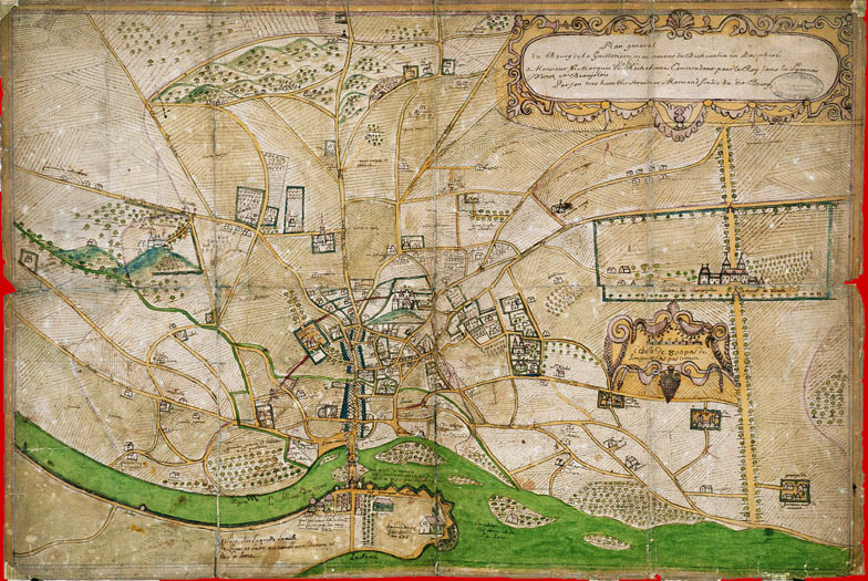
Français : Plan général du bourg de la Guillotière, mandement de Béchevelin en Dauphiné, dédié à Monsieur le marquis de Rochebonne, commandant pour le roy dans le Lyonnois, Forez et Beaujolois par son très humble serviteur Mornand, sindic du dit bourg |
||||||||||||||||||||
| Date | circa 1710 | ||||||||||||||||||||
| Medium | color ink | ||||||||||||||||||||
| Dimensions | height: 56 cm (22 in); width: 83 cm (32.6 in) | ||||||||||||||||||||
| Collection |
|
||||||||||||||||||||
| Accession number |
2 S 13 |
||||||||||||||||||||
| Notes |
Français : Plan reproduit en 1875 par G. Mermet de la Société de topographie historique. Il désigne : les propriétaires, les types de culture, les monuments et les Croix. En haut de document se trouve Montchal (c.-à-d. Montchat) |
||||||||||||||||||||
| Source/Photographer | 2S 13 | ||||||||||||||||||||
| Permission (Reusing this file) |
|
||||||||||||||||||||


File history
Click on a date/time to view the file as it appeared at that time.
| Date/Time | Thumbnail | Dimensions | User | Comment | |
|---|---|---|---|---|---|
| current | 00:09, 27 April 2016 | | 784 × 525 (184 KB) | 6PO (talk | contribs) | User created page with UploadWizard |
You cannot overwrite this file.
File usage on Commons
The following page uses this file:
File usage on other wikis
The following other wikis use this file:
- Usage on fr.wikipedia.org