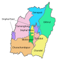
File:MANIPUR district map.svg
From Wikimedia Commons, the free media repository
Jump to navigation
Jump to search

Size of this PNG preview of this SVG file: 537 × 600 pixels. Other resolutions: 215 × 240 pixels | 430 × 480 pixels | 687 × 768 pixels | 917 × 1,024 pixels | 1,833 × 2,048 pixels | 640 × 715 pixels.
Original file (SVG file, nominally 640 × 715 pixels, file size: 233 KB)
File information
Structured data
Captions
Captions
District map of Manipur (2011)
Summary
[edit]| DescriptionMANIPUR district map.svg |
Deutsch: Verwaltungseinteilung von Manipur im Jahr 2011.
English: District map of Manipur in 2011. |
||
| Date | |||
| Source | derived from various maps of the Indian election comission and administrative maps | ||
| Author | Furfur | ||
| Permission (Reusing this file) |
I, the copyright holder of this work, hereby publish it under the following licenses:
This file is licensed under the Creative Commons Attribution-Share Alike 4.0 International license.
You may select the license of your choice. |
||
| Other versions |
|
||
| SVG development InfoField | This vector image was created with Adobe Illustrator. |
| This SVG file contains embedded text that can be translated into your language, using any capable SVG editor, text editor or the SVG Translate tool. For more information see: About translating SVG files. |
File history
Click on a date/time to view the file as it appeared at that time.
| Date/Time | Thumbnail | Dimensions | User | Comment | |
|---|---|---|---|---|---|
| current | 13:31, 23 December 2017 |  | 640 × 715 (233 KB) | Furfur (talk | contribs) | Bildkosmetik, SVG optimiert |
| 13:22, 23 December 2017 |  | 685 × 715 (255 KB) | Furfur (talk | contribs) | this is a more precise map, displaying the borders in 2011 | |
| 12:17, 4 June 2016 |  | 635 × 625 (702 KB) | Furfur (talk | contribs) | cosmetics | |
| 12:11, 4 June 2016 |  | 635 × 625 (704 KB) | Furfur (talk | contribs) | == {{int:filedesc}} == {{Information |Description={{User:Medium69/Traduction}} {{de|1=Verwaltungseinteilung von Manipur.}} {{en|1=District map of Manipur.}} |Source=derived from various maps of the Indian election comission and administrative maps |Dat... |
You cannot overwrite this file.
File usage on Commons
The following 14 pages use this file:
- File:MANIPUR district map-bh.svg
- File:MANIPUR district map-bn.svg
- File:MANIPUR district map-gu.svg
- File:MANIPUR district map-hi.svg
- File:MANIPUR district map-kn.svg
- File:MANIPUR district map-mr.svg
- File:MANIPUR district map-pa.svg
- File:MANIPUR district map-sat.svg
- File:MANIPUR district map-te.svg
- File:MANIPUR district map.svg
- File:MANIPUR district map as.svg
- File:Manipur district map.png
- File:Manipur districts as.png
- Template:Other versions/MANIPUR district map.svg
File usage on other wikis
The following other wikis use this file:
- Usage on de.wikipedia.org
- Usage on en.wikipedia.org
- Usage on fr.wikipedia.org
- Usage on hi.wikipedia.org
- Usage on incubator.wikimedia.org
- Usage on it.wikipedia.org
- Usage on kn.wikipedia.org
- Usage on pnb.wikipedia.org
- Usage on ur.wikipedia.org
- Usage on zh.wikipedia.org
Metadata
This file contains additional information such as Exif metadata which may have been added by the digital camera, scanner, or software program used to create or digitize it. If the file has been modified from its original state, some details such as the timestamp may not fully reflect those of the original file. The timestamp is only as accurate as the clock in the camera, and it may be completely wrong.
| Width | 640 |
|---|---|
| Height | 715 |

