File:MH17 map-zh-hant.svg
Jump to navigation
Jump to search

Size of this PNG preview of this SVG file: 512 × 256 pixels. Other resolutions: 320 × 160 pixels | 640 × 320 pixels | 1,024 × 512 pixels | 1,280 × 640 pixels | 2,560 × 1,280 pixels.
Original file (SVG file, nominally 512 × 256 pixels, file size: 231 KB)
Captions
Captions
Add a one-line explanation of what this file represents
Summary
[edit]| Description |
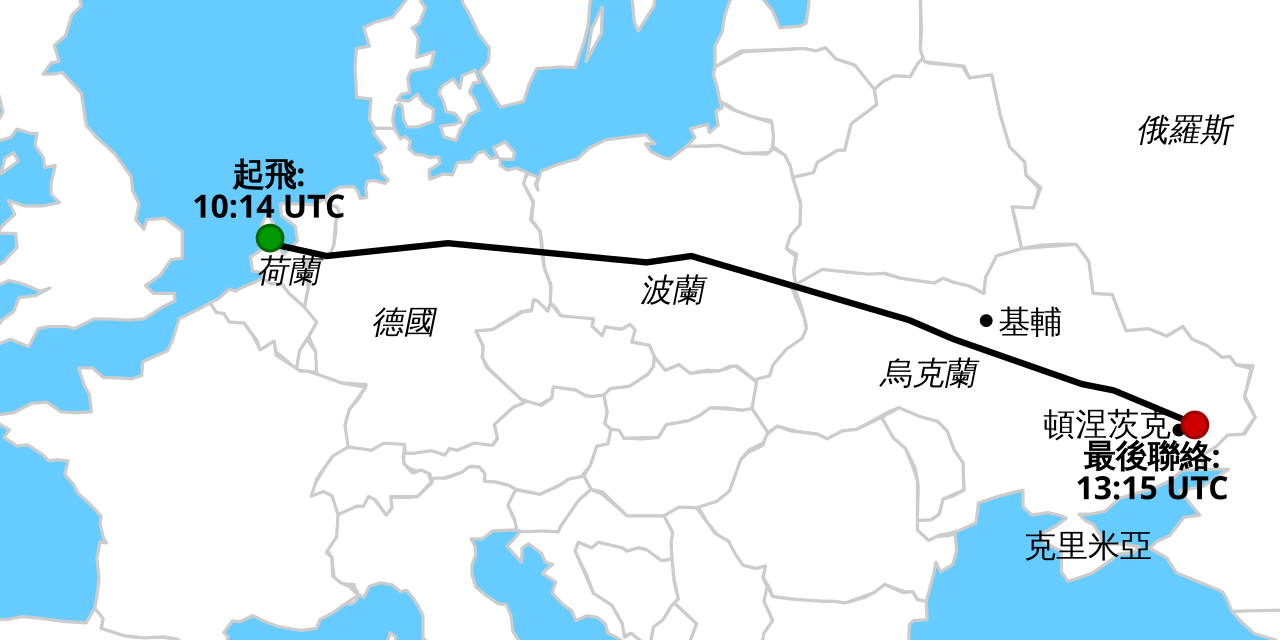
中文(繁體):馬來西亞航空17號班機空難 |
|
| Date | ||
| Source |
|
|
| Author | Geordie Bosanko and Cmglee | |
| Permission (Reusing this file) |
[] English: Base maps
English: Other maps
|


Licensing
[edit]
This file is licensed under the Creative Commons Attribution-Share Alike 3.0 Unported license.
- You are free:
- to share – to copy, distribute and transmit the work
- to remix – to adapt the work
- Under the following conditions:
- attribution – You must give appropriate credit, provide a link to the license, and indicate if changes were made. You may do so in any reasonable manner, but not in any way that suggests the licensor endorses you or your use.
- share alike – If you remix, transform, or build upon the material, you must distribute your contributions under the same or compatible license as the original.
File history
Click on a date/time to view the file as it appeared at that time.
| Date/Time | Thumbnail | Dimensions | User | Comment | |
|---|---|---|---|---|---|
| current | 09:23, 20 July 2014 | | 512 × 256 (231 KB) | Shinjiman (talk | contribs) | Half-width colon |
| 09:18, 20 July 2014 |  | 512 × 256 (231 KB) | Shinjiman (talk | contribs) | Unify the translation name as the zh-hans, the Taiwan translation had been uploaded as the name ending with zh-tw. | |
| 08:41, 19 July 2014 |  | 512 × 256 (231 KB) | Ffffnm (talk | contribs) | Reverted to version as of 07:44, 18 July 2014 | |
| 08:09, 18 July 2014 |  | 512 × 256 (231 KB) | Ffffnm (talk | contribs) | {{Information |description={{zh-hant|1=馬來西亞航空17號班機空難}} |date=2014-07-18 15:51:32 |source=File:MH17 map.svg |author=Geordie Bosanko and Cmglee |permission= |other_versions=[[:File:MH17 map-de.sv... | |
| 07:44, 18 July 2014 |  | 512 × 256 (231 KB) | Ffffnm (talk | contribs) | User created page with UploadWizard |
You cannot overwrite this file.
File usage on Commons
The following 23 pages use this file:
- Commons:WikiProject Aviation/recent uploads/2014 July 18
- File:MH17-Route 13z20.svg
- File:MH17 map-cs.svg
- File:MH17 map-de.svg
- File:MH17 map-en.svg
- File:MH17 map-es.svg
- File:MH17 map-fi.svg
- File:MH17 map-fr.svg
- File:MH17 map-he.svg
- File:MH17 map-hu.svg
- File:MH17 map-it.svg
- File:MH17 map-ja.svg
- File:MH17 map-lv.svg
- File:MH17 map-nl.svg
- File:MH17 map-ru.svg
- File:MH17 map-uk.svg
- File:MH17 map-zh-hans.svg
- File:MH17 map-zh-hant.svg
- File:MH17 map-zh-tw.svg
- File:Malaysia Airlines Flight 17 crash site.png
- File:Malaysia Airlines Flight 17 crash site IT.png
- File:Malaysia Airlines Flight 17 crash site without launcher position.png
- Template:Other versions/MH17
File usage on other wikis
The following other wikis use this file:
- Usage on zh.wikipedia.org