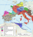
File:MajorianEmpire.png
From Wikimedia Commons, the free media repository
Jump to navigation
Jump to search

Size of this preview: 528 × 599 pixels. Other resolutions: 211 × 240 pixels | 423 × 480 pixels | 676 × 768 pixels | 1,220 × 1,385 pixels.
Original file (1,220 × 1,385 pixels, file size: 1.51 MB, MIME type: image/png)
File information
Structured data
Captions
Captions
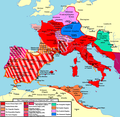
Western Roman Empire and campaigns under Emperor Majorian.
Weströmisches Reich und Feldzüge unter Kaiser Majorian
L' Empire romain d'occident et les campagnes sous l'empereur Majorien
Summary
[edit]| DescriptionMajorianEmpire.png |
English: The campaigns of Roman Emperor Majorian. During his four year reign, Majorian reconquered most of Hispania and southern Gaul. |
| Date | |
| Source | Own work |
| Author | Tataryn |
Licensing
[edit]I, the copyright holder of this work, hereby publish it under the following license:
This file is licensed under the Creative Commons Attribution-Share Alike 3.0 Unported license.
- You are free:
- to share – to copy, distribute and transmit the work
- to remix – to adapt the work
- Under the following conditions:
- attribution – You must give appropriate credit, provide a link to the license, and indicate if changes were made. You may do so in any reasonable manner, but not in any way that suggests the licensor endorses you or your use.
- share alike – If you remix, transform, or build upon the material, you must distribute your contributions under the same or compatible license as the original.
File history
Click on a date/time to view the file as it appeared at that time.
| Date/Time | Thumbnail | Dimensions | User | Comment | |
|---|---|---|---|---|---|
| current | 23:02, 26 October 2014 |  | 1,220 × 1,385 (1.51 MB) | Tataryn (talk | contribs) | Changed colour of East-West division line |
| 22:54, 26 October 2014 |  | 1,220 × 1,385 (1.51 MB) | Tataryn (talk | contribs) | Fixed Gades | |
| 16:57, 10 September 2014 |  | 1,220 × 1,385 (1.51 MB) | Tataryn (talk | contribs) | Better version | |
| 06:04, 5 August 2011 |  | 1,178 × 1,146 (139 KB) | Tataryn (talk | contribs) | Adding Ostrogothic color to legend. | |
| 04:38, 5 August 2011 |  | 1,178 × 1,146 (139 KB) | Tataryn (talk | contribs) |
You cannot overwrite this file.
File usage on Commons
There are no pages that use this file.
File usage on other wikis
The following other wikis use this file:
- Usage on br.wikipedia.org
- Usage on ca.wikipedia.org
- Usage on cs.wikipedia.org
- Usage on el.wikipedia.org
- Usage on en.wikipedia.org
- Usage on et.wikipedia.org
- Usage on fa.wikipedia.org
- Usage on fr.wikipedia.org
- Usage on hr.wikipedia.org
- Usage on it.wikipedia.org
- Socii e foederati
- Maggioriano
- Spagna romana
- Storia della Gallia tardo-antica e altomedievale
- Vandali
- Guerre romano-germaniche
- Gallia Narbonense
- Impero romano d'Occidente
- Sunierico
- Invasioni barbariche del V secolo
- Storia delle campagne dell'esercito romano in età tardo-imperiale
- Tardo impero romano
- Caduta dell'Impero romano d'Occidente
- Spagna (diocesi)
- Battaglia di Cartagena (461)
- Usage on ja.wikipedia.org
- Usage on ko.wikipedia.org
- Usage on lt.wikipedia.org
- Usage on nl.wikipedia.org
- Usage on ru.wikipedia.org
- Usage on sh.wikipedia.org
- Usage on sr.wikipedia.org
- Usage on sv.wikipedia.org
- Usage on uk.wikipedia.org
View more global usage of this file.
Metadata
This file contains additional information such as Exif metadata which may have been added by the digital camera, scanner, or software program used to create or digitize it. If the file has been modified from its original state, some details such as the timestamp may not fully reflect those of the original file. The timestamp is only as accurate as the clock in the camera, and it may be completely wrong.
| Horizontal resolution | 37.8 dpc |
|---|---|
| Vertical resolution | 37.8 dpc |
Categories:
- Maps of the Western Roman Empire
- Maps of the Vandals
- Maps of the Visigoths
- Maps of the Ostrogoths
- Maiorianus
- Maps of the Frankish territory
- Alamanni
- Maps of Europe in the 5th century
- Maps of the Ancient history of Morocco
- English-language maps
- Maps of the Rugii
- Scirii
- Maps of the Suebi
- Maps of the Kingdom of the Suebi
- Thüringerreich
Hidden categories: