File:Makhnowia.png
Jump to navigation
Jump to search
No higher resolution available.
Makhnowia.png (800 × 538 pixels, file size: 116 KB, MIME type: image/png)
Captions
Captions
Add a one-line explanation of what this file represents
Summary
[edit]

|
File:Makhnovia.svg is a vector version of this file. It should be used in place of this PNG file when not inferior.
File:Makhnowia.png → File:Makhnovia.svg
For more information, see Help:SVG. |
 |
| Description |
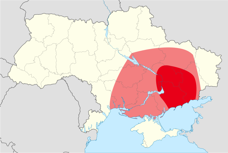
English: A map showing the approximate area of the anarchist en:Makhnovshchina in Ukraine |
| Date |
8 December 2008 (original upload date) |
| Source | Based on Image:Map of Ukraine political simple Oblast Donezk.png |
| Author | Myself |
| Permission (Reusing this file) |
GNU |
Licensing
[edit]

|
Permission is granted to copy, distribute and/or modify this document under the terms of the GNU Free Documentation License, Version 1.2 or any later version published by the Free Software Foundation; with no Invariant Sections, no Front-Cover Texts, and no Back-Cover Texts. A copy of the license is included in the section entitled GNU Free Documentation License. |
| This file is licensed under the Creative Commons Attribution-Share Alike 3.0 Unported license. | ||
| ||
| This licensing tag was added to this file as part of the GFDL licensing update. |
Original upload log
[edit]
Transferred from en.wikipedia to Commons by P.o.l.o..
The original description page was here. All following user names refer to en.wikipedia.
- 2008-12-08 00:10 Zazaban 1181×825× (35282 bytes) {{Information |Description= A map showing the approximate area of the anarchist [[free territory]] in Ukraine |Source= Based on [[Image:Map of Ukraine political simple Oblast Donezk.png]] |Date= December 7, 2008 |Author=Myself |Permission= GNU |other_ver
File history
Click on a date/time to view the file as it appeared at that time.
| Date/Time | Thumbnail | Dimensions | User | Comment | |
|---|---|---|---|---|---|
| current | 00:45, 14 November 2018 | | 800 × 538 (116 KB) | Thespoondragon (talk | contribs) | make same as vector file |
| 22:45, 11 October 2018 |  | 1,181 × 825 (34 KB) | Thespoondragon (talk | contribs) | changed map to match maps in books such as Nestor Makhno: Anarchy's Cossack, to increase accuracy | |
| 12:24, 7 February 2009 |  | 1,181 × 825 (34 KB) | P.o.l.o. (talk | contribs) | {{Information |Description={{en|A map showing the approximate area of the anarchist en:free territory in Ukraine}} |Source=Transferred from [http://en.wikipedia.org en.wikipedia]; transfer was stated to be made by User:P.o.l.o..<br/> (Original te |
You cannot overwrite this file.
File usage on Commons
The following 2 pages use this file:
File usage on other wikis
The following other wikis use this file:
- Usage on ar.wikipedia.org
- Usage on be-tarask.wikipedia.org
- Usage on be.wikipedia.org
- Usage on bg.wikipedia.org
- Usage on cs.wikipedia.org
- Usage on de.wikipedia.org
- Usage on es.wikipedia.org
- Usage on fa.wikipedia.org
- Usage on fr.wikipedia.org
- Usage on fr.wiktionary.org
- Usage on he.wikipedia.org
- Usage on id.wikipedia.org
- Usage on it.wikipedia.org
- Usage on ko.wikipedia.org
- Usage on lt.wikipedia.org
- Usage on lv.wikipedia.org
- Usage on nl.wikipedia.org
- Usage on no.wikipedia.org
- Usage on pt.wikipedia.org
- Usage on ro.wikipedia.org
- Usage on ru.wikipedia.org
- Usage on sh.wikipedia.org
- Usage on sk.wikipedia.org
- Usage on sr.wikipedia.org
- Usage on tr.wikipedia.org
- Usage on wa.wikipedia.org
- Usage on zh.wikipedia.org