File:Malaysia Airlines Flight 17 crash site IT.png
Jump to navigation
Jump to search
No higher resolution available.
Malaysia_Airlines_Flight_17_crash_site_IT.png (451 × 456 pixels, file size: 48 KB, MIME type: image/png)
Captions
Captions
Add a one-line explanation of what this file represents
Summary
[edit]| Description |
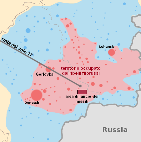
Italiano: mappa col punto di schianto del volo Malaysia Airlines 17.
linea nera - la rotta del volo Malaysia Airlines 17 area del territorio occupato dai ribelli filorussi (al momento dello schianto)
territorio precedentemente detenuto dagli insorti, ma ripreso dal governo ucraino
territorio russo
area approssimativa del lancio dei missili secondo le dichiarazioni del Consiglio di sicurezza nazionale ucraino e difesa (vedi fonte per maggiori dettagli)
I cerchi sono centri di popolazione - la dimensione del cerchio è proporzionata al numero di abitanti. |
| Date | |
| Source |
This file was derived from: Malaysia Airlines Flight 17 crash site.png:  Source of the data (The New York Times) |
| Author | Umberto NURS |
| Other versions |
[] English: Base maps
English: Other maps
|


Licensing
[edit]
I, the copyright holder of this work, hereby publish it under the following license:
This file is licensed under the Creative Commons Attribution-Share Alike 4.0 International license.
- You are free:
- to share – to copy, distribute and transmit the work
- to remix – to adapt the work
- Under the following conditions:
- attribution – You must give appropriate credit, provide a link to the license, and indicate if changes were made. You may do so in any reasonable manner, but not in any way that suggests the licensor endorses you or your use.
- share alike – If you remix, transform, or build upon the material, you must distribute your contributions under the same or compatible license as the original.
File history
Click on a date/time to view the file as it appeared at that time.
| Date/Time | Thumbnail | Dimensions | User | Comment | |
|---|---|---|---|---|---|
| current | 20:56, 4 August 2014 | | 451 × 456 (48 KB) | Umberto NURS (talk | contribs) | User created page with UploadWizard |
You cannot overwrite this file.
File usage on Commons
The following 24 pages use this file:
- User:Magog the Ogre/Maps of conflicts/2014 August
- Commons:WikiProject Aviation/recent uploads/2014 August 4
- File:MH17-Route 13z20.svg
- File:MH17 map-cs.svg
- File:MH17 map-de.svg
- File:MH17 map-en.svg
- File:MH17 map-es.svg
- File:MH17 map-fi.svg
- File:MH17 map-fr.svg
- File:MH17 map-he.svg
- File:MH17 map-hu.svg
- File:MH17 map-it.svg
- File:MH17 map-ja.svg
- File:MH17 map-lv.svg
- File:MH17 map-nl.svg
- File:MH17 map-ru.svg
- File:MH17 map-uk.svg
- File:MH17 map-zh-hans.svg
- File:MH17 map-zh-hant.svg
- File:MH17 map-zh-tw.svg
- File:Malaysia Airlines Flight 17 crash site.png
- File:Malaysia Airlines Flight 17 crash site IT.png
- File:Malaysia Airlines Flight 17 crash site without launcher position.png
- Template:Other versions/MH17