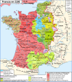
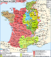
File:Map France 1180-uk.svg
Jump to navigation
Jump to search

Size of this PNG preview of this SVG file: 527 × 600 pixels. Other resolutions: 211 × 240 pixels | 422 × 480 pixels | 675 × 768 pixels | 900 × 1,024 pixels | 1,800 × 2,048 pixels | 988 × 1,124 pixels.
Original file (SVG file, nominally 988 × 1,124 pixels, file size: 1.68 MB)
Categories:
- SVG maps of the history of France
- Ukrainian-language SVG maps showing history
- Maps showing 12th-century history
- Maps of France in the 12th century
- Angevin Empire
- County of Champagne
- Maps of the county of Flanders
- Duchy of Burgundy
- County of Burgundy
- Duchy of Brittany
- Maps of the history of Hainaut
- Maps of the history of Brabant
- Maps of the Duchy of Lorraine
- Duchy of Normandy
- Maine (province)
- County of Anjou
- Touraine
- Duchy of Aquitaine
- Nivernais
- Bourbonnais
- Maps of Poitou
- Angoumois
- County of Auvergne
- Maps of Dauphiné
- Maps of the Duchy of Savoy
- Maps of the history of Provence
- County of Toulouse
- County of Foix
- Roussillon
- Kingdom of Navarre
- Duchy of Luxembourg
- Astarac
- Geography of Béarn
- Bigorre
- Maps of Comminges
- Maps of Aunis
- Perche


