File:Map France 1477-ru.svg
Jump to navigation
Jump to search

Size of this PNG preview of this SVG file: 556 × 599 pixels. Other resolutions: 223 × 240 pixels | 445 × 480 pixels | 713 × 768 pixels | 950 × 1,024 pixels | 1,900 × 2,048 pixels | 900 × 970 pixels.
Original file (SVG file, nominally 900 × 970 pixels, file size: 1.16 MB)
Captions
Captions
Add a one-line explanation of what this file represents
This W3C-unspecified vector image was created with Inkscape .
| Description |
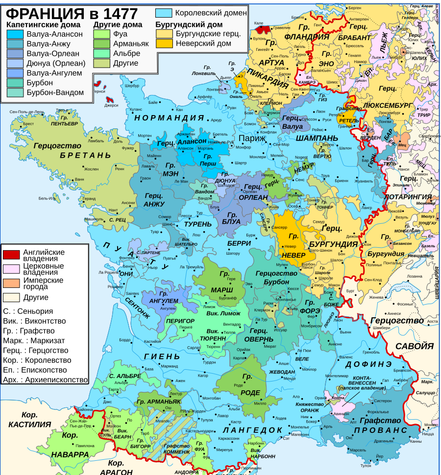
English: Map of the France in 1477.
Русский: Карта Франции в 1477. |
||||||||
| Date | |||||||||
| Source |
English: Own work. Image renamed from Image:Map France History XVe.svg. Data:
Русский: Собственная работа. Переведенное изображение Image:Map France History XVe.svg. Дата:
|
||||||||
| Author | Orror (French original); Volodimer (Russian translation) | ||||||||
| Permission (Reusing this file) |
I, the copyright holder of this work, hereby publish it under the following licenses:
This file is licensed under the Creative Commons Attribution-Share Alike 2.5 Generic license.
You may select the license of your choice. |
||||||||
| Other versions |
Derivative works of this file: Map Southern France 1477-ru.png
[]
|


|
This SVG file contains embedded text that can be translated into your language, using any capable SVG editor, text editor or the SVG Translate tool. For more information see: About translating SVG files. |
File history
Click on a date/time to view the file as it appeared at that time.
| Date/Time | Thumbnail | Dimensions | User | Comment | |
|---|---|---|---|---|---|
| current | 16:47, 8 June 2015 | | 900 × 970 (1.16 MB) | Qbli2mHd (talk | contribs) | исправлены ошибки |
| 14:23, 23 February 2008 |  | 900 × 970 (1.22 MB) | Vladimir Solovjev (talk | contribs) | {{Created with Inkscape}} {{Information |Description= {{en|Map of the France in 1477.}} {{ru|Карта Франции в 1477.}} |Source= {{en|Own work. Image renamed from Image:Map France History XVe.svg. Data: # Map “[[:Image:France XVe siècle |
You cannot overwrite this file.
File usage on Commons
The following 12 pages use this file:
- User:Chumwa/OgreBot/Charente-Maritime/2015 June 1-10
- File:Map France 1180-ru.svg
- File:Map France 1477-br.svg
- File:Map France 1477-de.svg
- File:Map France 1477-en.svg
- File:Map France 1477-es.svg
- File:Map France 1477-fr.svg
- File:Map France 1477-ru.svg
- File:Map France 1477-uk.svg
- File:Map Southern France 1477-ru.png
- File:Pays de Retz.jpg
- Template:Other versions/Map France 1477
File usage on other wikis
The following other wikis use this file:
- Usage on ba.wikipedia.org
- Usage on be.wikipedia.org
- Usage on bg.wikipedia.org
- Usage on hy.wikipedia.org
- Usage on ka.wikipedia.org
- Usage on lt.wikipedia.org
- Usage on ru.wikipedia.org
- Список глав Франции
- Людовик XI
- Альбре
- Бургундские войны
- Карл Смелый
- Дом Фуа
- Бургундское герцогство
- Участник:Vladimir Solovjev/Заготовки
- Бретань (герцогство)
- Бурбон (герцогство)
- Безумная война
- Лига общественного блага
- Файл:Map France 1477-ru.jpg
- Экспансия Швейцарского союза
- Лонгвиль (графство и герцогство)