File:Map in Treaty of Peking 1860.jpg
Jump to navigation
Jump to search
No higher resolution available.
Map_in_Treaty_of_Peking_1860.jpg (600 × 416 pixels, file size: 83 KB, MIME type: image/jpeg)
Captions
Captions
Add a one-line explanation of what this file represents
| Description |
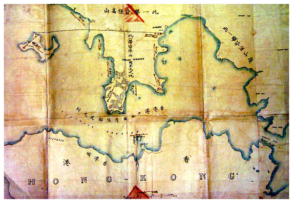
English: Map of Hong Kong in First Convention of Peking in 1860. The copy is in the Public Record Office of Hong Kong Government. |
|||||
| Date | ||||||
| Source |
中文:來自互聯網。 English: From internet. |
|||||
| Author | Unknown author | |||||
| Permission (Reusing this file) |
|
|||||
| Other versions | Image:Map of Hong Kong in First Convention of Peking in 1860.jpg |
.svg)

File history
Click on a date/time to view the file as it appeared at that time.
| Date/Time | Thumbnail | Dimensions | User | Comment | |
|---|---|---|---|---|---|
| current | 16:48, 27 January 2007 | | 600 × 416 (83 KB) | HenryLi (talk | contribs) | Map in Treaty of Peaking between Chinese and British in 1860. Date: 1860-03-20 (28th day of 2nd month in the 10th year of Ham Fung) The copy is in the Public Record Office of Hong Kong Government. |
You cannot overwrite this file.
File usage on Commons
There are no pages that use this file.
File usage on other wikis
The following other wikis use this file:
- Usage on de.wikipedia.org
- Usage on en.wikipedia.org
- Usage on hy.wikipedia.org
- Usage on zh-yue.wikipedia.org
- Usage on zh.wikipedia.org