File:Map of Los Rodeos Airport.png
Jump to navigation
Jump to search
No higher resolution available.
Map_of_Los_Rodeos_Airport.png (488 × 124 pixels, file size: 10 KB, MIME type: image/png)
Captions
Captions
Add a one-line explanation of what this file represents

|
File:Map Tenerife Disaster EN.svg is a vector version of this file. It should be used in place of this PNG file.
File:Map of Los Rodeos Airport.png → File:Map Tenerife Disaster EN.svg
For more information, see Help:SVG. |
Summary
[edit]

|
This file was moved to Wikimedia Commons from zh.wikipedia using a bot script. All source information is still present. It requires review. Additionally, there may be errors in any or all of the information fields; information on this file should not be considered reliable and the file should not be used until it has been reviewed and any needed corrections have been made. Once the review has been completed, this template should be removed. For details about this file, see below. Check now! |
| Description |
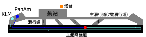
中文:加納利空難機場配置圖 from NL wiki
原圖片頁參見:nl:Afbeelding:KaartjeVliegrampTenerife.png,已經轉成commons:Image:Map Tenerife Disaster NL.svg,由上傳者修改註釋為中文。 |
| Date | 12 June 2005 (original upload date) |
| Source | Transferred from zh.wikipedia to Commons by Shizhao using CommonsHelper. |
| Author | The original uploader was SElephant at Chinese Wikipedia. |
| Other versions |
[]
|
Licensing
[edit]

|
Permission is granted to copy, distribute and/or modify this document under the terms of the GNU Free Documentation License, Version 1.2 or any later version published by the Free Software Foundation; with no Invariant Sections, no Front-Cover Texts, and no Back-Cover Texts. A copy of the license is included in the section entitled GNU Free Documentation License. |
| This file is licensed under the Creative Commons Attribution-Share Alike 3.0 Unported license. | ||
| ||
| This licensing tag was added to this file as part of the GFDL licensing update. |
Original upload log
[edit]
The original description page was here. All following user names refer to zh.wikipedia.
- 2007-01-27 09:32 Loveaozora 488×124× (10518 bytes) {{subst:Information| |A= 加納利空難機場配置圖 |B= NL wiki |C= 20070127 |D= loveaozora |E= 版權許可資料 |F= 檔案其他版本(選填) }}
- 2005-06-12 17:13 SElephant 488×124× (7097 bytes) 加納利空難機場配置圖 from NL wiki
File history
Click on a date/time to view the file as it appeared at that time.
| Date/Time | Thumbnail | Dimensions | User | Comment | |
|---|---|---|---|---|---|
| current | 03:13, 9 November 2010 | 488 × 124 (10 KB) | File Upload Bot (Magnus Manske) (talk | contribs) | {{BotMoveToCommons|zh.wikipedia|year={{subst:CURRENTYEAR}}|month={{subst:CURRENTMONTHNAME}}|day={{subst:CURRENTDAY}}}} {{Information |Description={{zh|加納利空難機場配置圖 from NL wiki 原圖片頁參見[[:zh::nl:Afbeelding:KaartjeVliegrampTen |
You cannot overwrite this file.
File usage on Commons
The following 12 pages use this file:
- File:Los Rodeos KLm-PanAm.png
- File:Los Rodeos KLm-PanAm FR.png
- File:Map Tenerife Disaster.svg
- File:Map Tenerife Disaster HE.svg
- File:Map Tenerife Disaster IT.jpg
- File:Map Tenerife Disaster IT backtaxi.jpg
- File:Map Tenerife Disaster NL.svg
- File:Map of Los Rodeos Airport.png
- File:Tenerife-airport-disaster-crashsite-overview-german.png
- File:Tenerife Disaster EST.jpg
- File:Tenerife dis chart1-ru.svg
- Template:Other versions/Map Tenerife Disaster