File:Map of Saint-Petersburg in 1720 (Homann).jpg

Original file (1,476 × 1,264 pixels, file size: 740 KB, MIME type: image/jpeg)
Captions
Captions
| Description |
Português: Mapa de São Petersburgo. Gravura pintada sob aquarela, 50.5x59.5 cm. Datada da década de 1720 (antes de 1725)
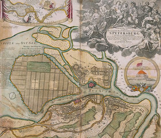
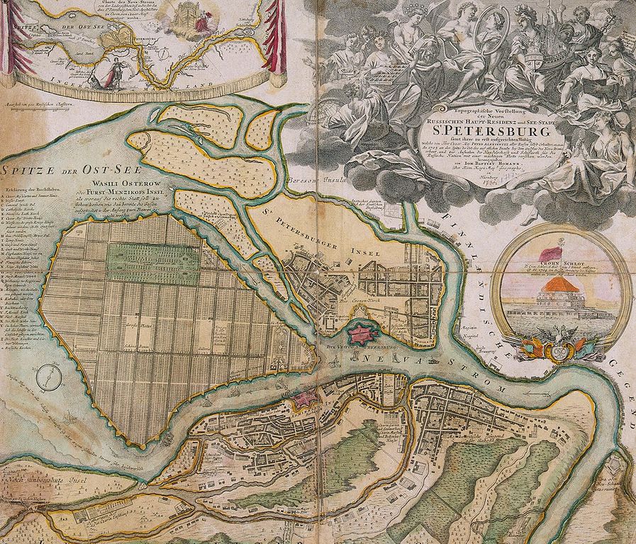
English: Map of Saint-Petersburg. , Etching with line engraving, painted in watercolour, 50.5x59.5 cm. 1720s (before 1725)
Русский: План Санкт-Петербурга И. Хоманна. Бумага, офорт, резец, акварель. 50.5х59.5 см. 1720-е (до 1725)
Deutsch: Johann Baptist Homann (1664–1724): Topographische Vorstellung der Neuen Russischen Haupt-Residenz und See-Stadt St. Petersburg samt ihrer zu erst aufgerichteten Vestung: welche von Ihro Czaar Maj. Petro Alexiewitz aller Russen Selbst Erhalter etc., etc., etc. An. 1703 an der Spitze der Ost-See auf etlichen Insuln bey dem Außfluss des Neva Stroms erbaut und zur Aufnahm der Handelsschafft und Schiffarth für die Russische Nation mit einer mächtigen Flotte versehen worden herausgegeben von Ioh. Baptist Homann, Der Röm. Kays. Maj. Geographo, Nürnberg [zwischen 1719 und 1723]
Eine der frühesten Darstellungen Sankt Petersburgs. Die Nebenkarte in der linken oberen Ecke zeigt die Lage der Stadt an der Mündung des Flusses Newa. Der Newski Prospect, die heutige Prachtstraße St. Petersburgs, befand sich zur Zeit der Herstellung der Karte noch in Planung.
|
|||||||||||||||||||||||
| Date | between 1719 and 1723 | |||||||||||||||||||||||
| Source | small ver., large ver. | |||||||||||||||||||||||
| Author |
|
|||||||||||||||||||||||
| Permission (Reusing this file) |
|
|||||||||||||||||||||||
| Other versions |
Derivative works of this file: Map of Saint-Petersburg in 1720 (Homann) corner Nevskiy and Fontanka.jpg  |
|||||||||||||||||||||||
.jpg)
_corner_Nevskiy_and_Fontanka.jpg)
File history
Click on a date/time to view the file as it appeared at that time.
| Date/Time | Thumbnail | Dimensions | User | Comment | |
|---|---|---|---|---|---|
| current | 17:40, 25 May 2009 | | 1,476 × 1,264 (740 KB) | Kaganer (talk | contribs) | large size |
| 12:31, 5 April 2009 |  | 549 × 470 (78 KB) | AndreyA (talk | contribs) | {{Information |Description={{En|Map of Saint-Petersburg in 1720}}{{En|План Санкт-Петербурга И. Хоманна.1720}} |Source=[http://www.encspb.ru/image.php?file=big%2f2803983508.jpg Энциклопедия Санкт-Петербур |
You cannot overwrite this file.
File usage on Commons
The following page uses this file:
File usage on other wikis
The following other wikis use this file:
- Usage on azb.wikipedia.org
- Usage on ba.wikipedia.org
- Usage on bg.wikipedia.org
- Usage on bxr.wikipedia.org
- Usage on ca.wikipedia.org
- Usage on de.wikipedia.org
- Usage on en.wikipedia.org
- Usage on fr.wikipedia.org
- Usage on he.wikipedia.org
- Usage on hy.wikipedia.org
- Usage on hyw.wikipedia.org
- Usage on ka.wikipedia.org
- Usage on ru.wikipedia.org
- Usage on uk.wikipedia.org
.jpg&oldid=660444216)