File:Map of United States accessible colors shown.svg
Jump to navigation
Jump to search

Size of this PNG preview of this SVG file: 548 × 349 pixels. Other resolutions: 320 × 204 pixels | 640 × 408 pixels | 1,024 × 652 pixels | 1,280 × 815 pixels | 2,560 × 1,630 pixels.
Original file (SVG file, nominally 548 × 349 pixels, file size: 126 KB)
Captions
Captions
Add a one-line explanation of what this file represents
Summary
[edit]
| Description |
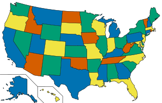
English: A map of the United States showing four colors. According to the Four color theorem, only four colors are needed to complete a map containing any type of shapes provided that two touching shapes share a border of at least two points (a line).
This colouring is not the only way to four-colour the map: for example, Florida could be orange. This graphic uses a colour palette accessible to colour blind people. |
| Date | |
| Source |
This file was derived from: Map of United States vivid colors shown.svg |
| Author | w:User:Derfel73, w:User:Dbenbenn, w:User:Strangerpete, inductiveload |
This image relies, or partly relies, on colours convey information. The colors used have been chosen to remain visually distinct even to viewers with colour blindness. When modifying this image, make sure that the result remains accessible to colour-blind users.
|
Licensing
[edit]
This file is licensed under the Creative Commons Attribution-Share Alike 3.0 Unported license.
- You are free:
- to share – to copy, distribute and transmit the work
- to remix – to adapt the work
- Under the following conditions:
- attribution – You must give appropriate credit, provide a link to the license, and indicate if changes were made. You may do so in any reasonable manner, but not in any way that suggests the licensor endorses you or your use.
- share alike – If you remix, transform, or build upon the material, you must distribute your contributions under the same or compatible license as the original.
File history
Click on a date/time to view the file as it appeared at that time.
| Date/Time | Thumbnail | Dimensions | User | Comment | |
|---|---|---|---|---|---|
| current | 15:02, 24 January 2022 | | 548 × 349 (126 KB) | Inductiveload (talk | contribs) | c:User:Rillke/bigChunkedUpload.js: |
| 14:40, 24 January 2022 |  | 548 × 349 (127 KB) | Inductiveload (talk | contribs) | c:User:Rillke/bigChunkedUpload.js: Make RI/NY different colours, as they share a water border. Technically not relevant in this diagram, but removes doubt | |
| 14:34, 24 January 2022 |  | 548 × 349 (126 KB) | Inductiveload (talk | contribs) | c:User:Rillke/bigChunkedUpload.js: |
You cannot overwrite this file.
File usage on Commons
There are no pages that use this file.
File usage on other wikis
The following other wikis use this file:
- Usage on bn.wikibooks.org
- Usage on cs.wikipedia.org
- Usage on en.wikipedia.org
- Usage on sq.wikipedia.org