File:Map of the Kiev tram (1918).jpg
Jump to navigation
Jump to search
Size of this preview: 800 × 543 pixels. Other resolutions: 320 × 217 pixels | 640 × 434 pixels | 1,024 × 695 pixels | 1,280 × 869 pixels | 2,560 × 1,738 pixels | 4,096 × 2,780 pixels.
Original file (4,096 × 2,780 pixels, file size: 2.78 MB, MIME type: image/jpeg)
Captions
Captions
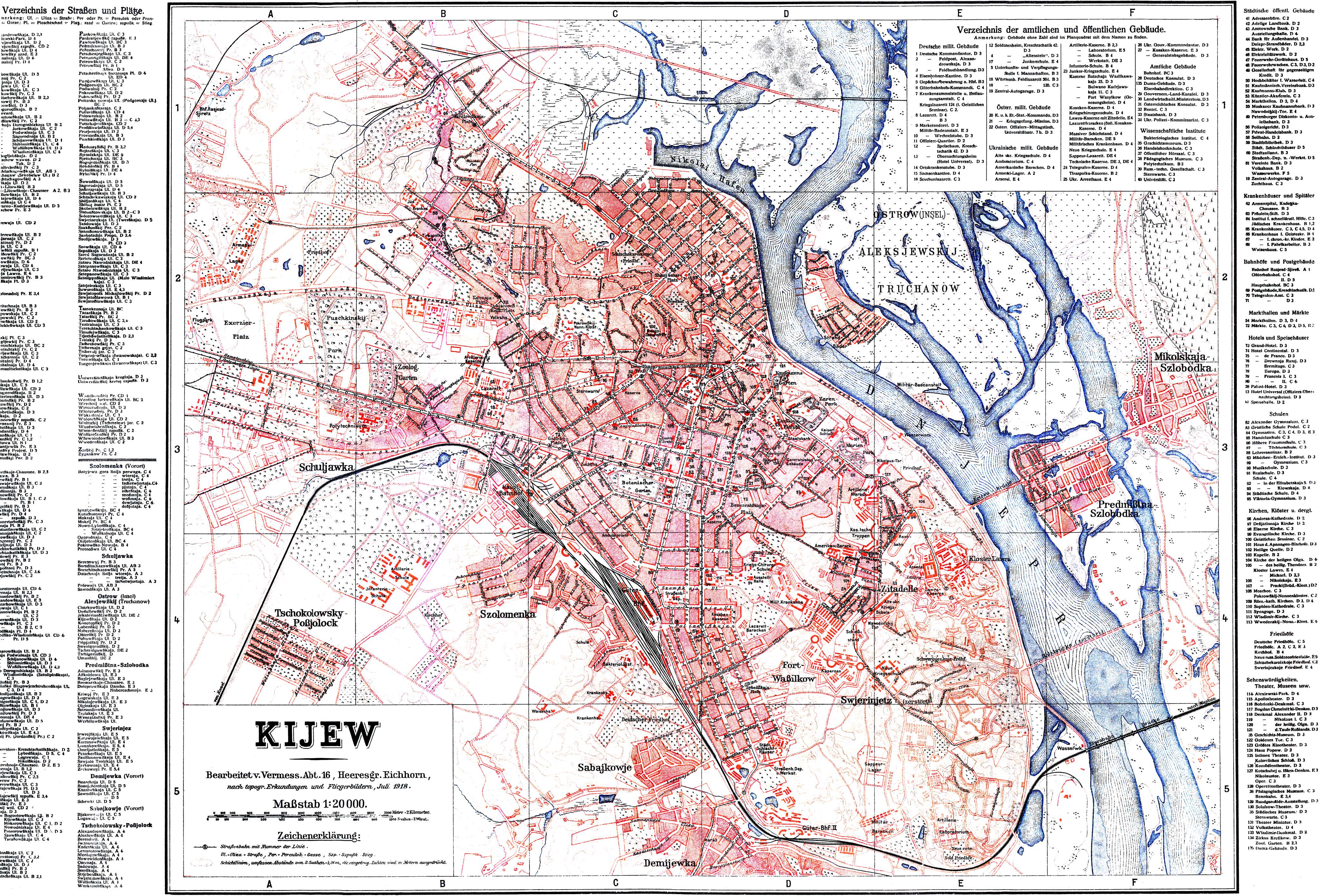
German street map of Kiev from 1918
| Description |
English: German street map of Kiev from 1918 with street directory and Kiev tram lines.
Deutsch: Deutsche Straßenkarte von Kiew von 1918 mit Straßenverzeichnis und Straßenbahnlinien der Kiewer Straßenbahn. |
||||
| Date | |||||
| Source | From [1]. Special thanks to Matthias Kühl for providing materials, Konstantin Antonenko and Konstantin Kozlov for processing. 10 September 2005 | ||||
| Author | Vermessungsabteilung 16, Heeresgruppe Eichhorn | ||||
| Permission (Reusing this file) |
|
||||
File history
Click on a date/time to view the file as it appeared at that time.
| Date/Time | Thumbnail | Dimensions | User | Comment | |
|---|---|---|---|---|---|
| current | 03:38, 18 November 2006 | | 4,096 × 2,780 (2.78 MB) | DDima (talk | contribs) | A map of the Kiev tram (1918). In German. From [http://www.mashke.org/kievtram/history/schemes/1918/] {{PD-old}} Category:Maps of Kiev Category:Trams in Kiev Category:1918 |
You cannot overwrite this file.
File usage on Commons
The following page uses this file:
File usage on other wikis
The following other wikis use this file:
- Usage on de.wikipedia.org
- Usage on fr.wikipedia.org
- Usage on pl.wikipedia.org
- Usage on uk.wikipedia.org
.jpg&oldid=828757713)