File:Mapa del Virreinato de la Nueva España (1794).svg
Jump to navigation
Jump to search

Size of this PNG preview of this SVG file: 700 × 600 pixels. Other resolutions: 280 × 240 pixels | 561 × 480 pixels | 897 × 768 pixels | 1,196 × 1,024 pixels | 2,391 × 2,048 pixels | 885 × 758 pixels.
Original file (SVG file, nominally 885 × 758 pixels, file size: 1.41 MB)
Captions
Captions
Add a one-line explanation of what this file represents
Summary
[edit]| Description |
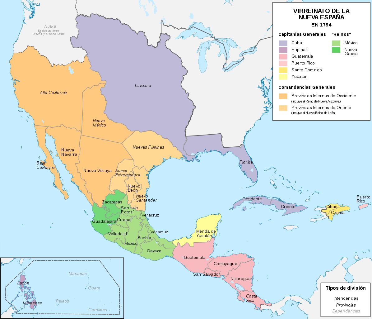
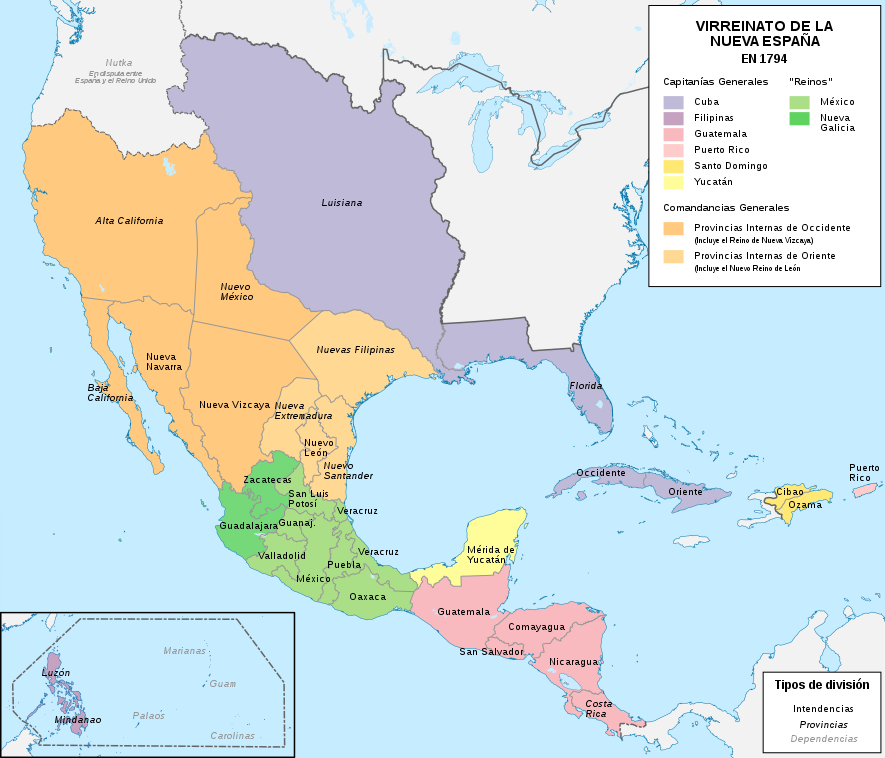
Español: Mapa político del Virreinato de la Nueva España (1794) |
| Date | |
| Source |
Own work |
| Author | Milenioscuro |
| Other versions |
|
.svg)
.svg)
.svg&action=edit§ion=1)
.JPG)
Licensing
[edit].svg&action=edit§ion=2)
I, the copyright holder of this work, hereby publish it under the following license:
This file is licensed under the Creative Commons Attribution-Share Alike 4.0 International license.
- You are free:
- to share – to copy, distribute and transmit the work
- to remix – to adapt the work
- Under the following conditions:
- attribution – You must give appropriate credit, provide a link to the license, and indicate if changes were made. You may do so in any reasonable manner, but not in any way that suggests the licensor endorses you or your use.
- share alike – If you remix, transform, or build upon the material, you must distribute your contributions under the same or compatible license as the original.
File history
Click on a date/time to view the file as it appeared at that time.
| Date/Time | Thumbnail | Dimensions | User | Comment | |
|---|---|---|---|---|---|
| current | 10:58, 13 November 2018 | | 885 × 758 (1.41 MB) | Milenioscuro (talk | contribs) | User created page with UploadWizard |
You cannot overwrite this file.
File usage on Commons
The following 14 pages use this file:
- User:Donald Trung/Partition of Mexico
- Commons:Graphic Lab/Map workshop/Archive/2021
- File:Mapa Virreinato Nueva España.png
- File:Mapa del Virreinato de la Nueva España (1794).svg
- File:Mapa del Virreinato de la Nueva España (1819).svg
- File:Nueva España 1795.png
- File:Territorial evolution of Mexico and the USA (1800–1900) 01.svg
- File:Territorial evolution of Mexico and the USA (1800–1900) 02.svg
- File:Viceroyalty of New Spain and the United States of America 1800.svg
- File:Viceroyalty of the New Spain 1800 (without Philippines).png
- Category:Mexico in the 1550s
- Category:Spanish Florida
- Category:Spanish Texas
- Category:Viceroyalty of New Spain
_01.svg)
_02.svg)
.png)
File usage on other wikis
The following other wikis use this file:
- Usage on af.wikipedia.org
- Usage on ar.wikipedia.org
- Usage on ast.wikipedia.org
- Usage on br.wikipedia.org
- Usage on ca.wikipedia.org
- Usage on cs.wikipedia.org
- Usage on el.wikipedia.org
- Usage on en.wikipedia.org
- New Spain
- New Navarre
- Captaincy General of Guatemala
- Eulalia Pérez de Guillén Mariné
- Crown of Castile
- Arizpe
- New Philippines
- Captaincy General of Santo Domingo
- Captaincy General of Puerto Rico
- Captaincy General of Cuba
- Captaincy General of Yucatán
- Talk:Spanish Empire/Archive 5
- User:Falcaorib/Canada, United States and Mexico
- Usage on es.wikipedia.org
- California
- Conquista de México
- Nuevo Reino de León
- Historia de Filipinas
- Conquista de Yucatán
- Florida española
- Comandancia General de las Provincias Internas
- Nuevas Filipinas
- Organización territorial del Virreinato de Nueva España
- Portal:Costa Rica
- Portal:Nueva España/La foto del mes
- Historia territorial del Estado de México
- Santa Fe de Nuevo México
- Nueva Navarra
- Virreinato de Nueva España
- Regionalización de la Nueva España y división territorial de México
- Población de México en la Conquista
- Reunificación centroamericana
- Censo de Revillagigedo
View more global usage of this file.
.svg)
Metadata
.svg&oldid=843979979)
Categories:
- Maps of subdivisions of the Viceroyalty of New Spain
- Maps of the history of the United States
- Maps of old administrative divisions of Mexico
- Maps of colonial California
- Maps of the Captaincy General of Cuba
- SVG maps of the Viceroyalty of New Spain
- Spanish-language SVG maps showing history of North America
- SVG maps of the history of Mexico
- Territorial evolution of Mexico
- 1794 maps of North America
- Maps of Spanish Louisiana
- Alta California
- Maps of Spanish Texas
- Maps of Spanish Florida
- Maps showing 1794