File:Mappa assedio Alessandria (1657).png
Jump to navigation
Jump to search

Size of this preview: 788 × 599 pixels. Other resolutions: 316 × 240 pixels | 631 × 480 pixels | 1,010 × 768 pixels | 1,280 × 974 pixels | 2,560 × 1,948 pixels | 10,838 × 8,245 pixels.
Original file (10,838 × 8,245 pixels, file size: 114.01 MB, MIME type: image/png)
Captions
Captions
Add a one-line explanation of what this file represents
Summary
[edit].png&action=edit§ion=1)
| Title |
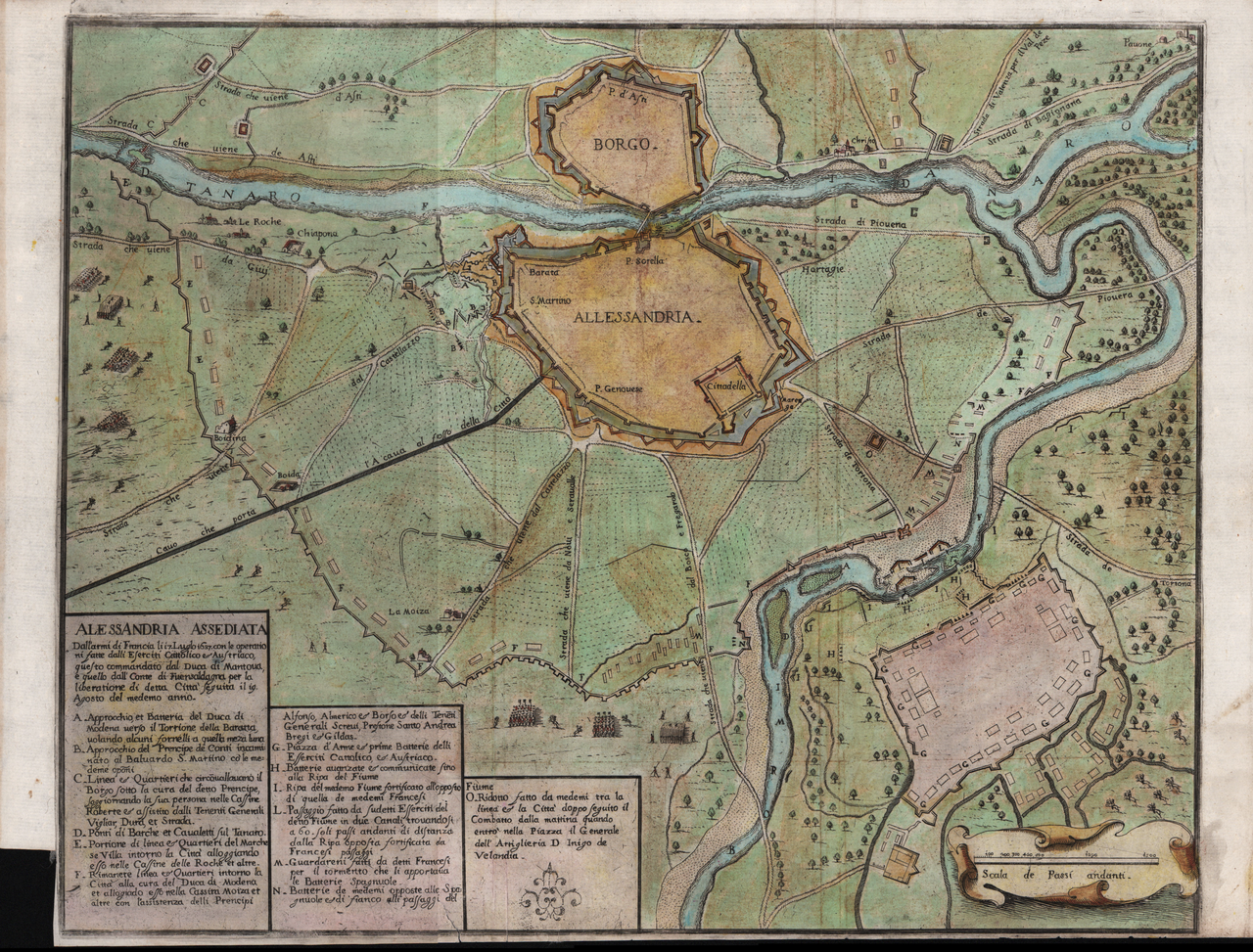
Italiano: Alessandria, assediata Dall'armi di Francia li 17 Luglio 1657 con le operationi fatte dalli Eserciti Cattolico et Austriaco, questo commandato dal Duca di Mantoua, e quello dall'Conte di Fuensaldagna per la liberatione di detta Citta seguita il 19 Agosto del mede.mo anno English: Alessandria, besieged by the arms of France on the 17th of July, 1657, with the operations conducted by the Catholic and Austrian armies, the former commanded by the Duke of Mantua and the latter by Count Fuensaldagna, for the liberation of said city, which followed on the 19th of August of the same year. |
|||||||||||||||||
| Date | ||||||||||||||||||
| Source | Bibliothèque nationale de France, Département Cartes et plans, GE D-14209, Registre B, 2304 108 | |||||||||||||||||
| Creator |
Anonymous |
|||||||||||||||||
| Permission (Reusing this file) |
|
|||||||||||||||||
| Geotemporal data | ||||||||||||||||||
| Date depicted | circa 1657 | |||||||||||||||||
| Map location | Alessandria | |||||||||||||||||
| Map type | thematic map | |||||||||||||||||
| Scale |
Italiano: Scala de passi andanti |
|||||||||||||||||
| Bibliographic data | ||||||||||||||||||
| Language | Italian | |||||||||||||||||
| Archival data | ||||||||||||||||||
| Collection |
|
|||||||||||||||||
| Dimensions | height: 305 cm (10 ft); width: 380 cm (12.4 ft) | |||||||||||||||||
| Medium | etching print on paper | |||||||||||||||||
File history
Click on a date/time to view the file as it appeared at that time.
| Date/Time | Thumbnail | Dimensions | User | Comment | |
|---|---|---|---|---|---|
| current | 08:38, 23 February 2024 | | 10,838 × 8,245 (114.01 MB) | Brigante mandrogno (talk | contribs) | Uploaded a work by Anonymous from Bibliothèque nationale de France, Département Cartes et plans, GE D-14209, Registre B, 2304 108 with UploadWizard |
You cannot overwrite this file.
File usage on Commons
There are no pages that use this file.
File usage on other wikis
The following other wikis use this file:
- Usage on it.wikipedia.org
.png&oldid=854856775)