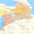
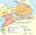
File:Maps of the Armenian Empire of Tigranes-ru.svg
From Wikimedia Commons, the free media repository
Jump to navigation
Jump to search

Size of this PNG preview of this SVG file: 512 × 506 pixels. Other resolutions: 243 × 240 pixels | 486 × 480 pixels | 777 × 768 pixels | 1,036 × 1,024 pixels | 2,072 × 2,048 pixels.
Original file (SVG file, nominally 512 × 506 pixels, file size: 59 KB)
File information
Structured data
Captions
Captions
Add a one-line explanation of what this file represents
Summary
[edit]| DescriptionMaps of the Armenian Empire of Tigranes-ru.svg |
English: The Empire of Tigran the Great, 95-66 BC |
| Date | |
| Source |
This file was derived from: |
| Author |
|
| Other versions |
[edit]
|
Licensing
[edit]This file is licensed under the Creative Commons Attribution 3.0 Unported license.
- You are free:
- to share – to copy, distribute and transmit the work
- to remix – to adapt the work
- Under the following conditions:
- attribution – You must give appropriate credit, provide a link to the license, and indicate if changes were made. You may do so in any reasonable manner, but not in any way that suggests the licensor endorses you or your use.
File history
Click on a date/time to view the file as it appeared at that time.
| Date/Time | Thumbnail | Dimensions | User | Comment | |
|---|---|---|---|---|---|
| current | 22:15, 10 June 2021 |  | 512 × 506 (59 KB) | Akeosnhaoe (talk | contribs) | arbela |
| 14:07, 4 June 2021 |  | 512 × 506 (59 KB) | Akeosnhaoe (talk | contribs) | {{Information |Description={{ru|Великая Армения при Тигране Великом.}}{{en|The Empire of Tigran the Great, 95-66 BC}} |Source={{Derived from|Maps of the Armenian Empire of Tigranes-pt.svg|Maps of the Armenian Empire of Tigranes.gif|display=50}} |Date=2021-06-04 |Author=*Maps of the Armenian Empire of Tigranes.gif: Robert H. Hewsen, uploaded by {{U|Nareklm}} *[[:File:Maps of the Armenian Empire of T... |
You cannot overwrite this file.
File usage on Commons
The following 8 pages use this file:
- File:Map of the Armenian Empire of Tigranes (English).svg
- File:Maps of the Armenian Empire of Tigranes-es.svg
- File:Maps of the Armenian Empire of Tigranes-fr.svg
- File:Maps of the Armenian Empire of Tigranes-he.svg
- File:Maps of the Armenian Empire of Tigranes-pt.svg
- File:Maps of the Armenian Empire of Tigranes-ru.svg
- File:Maps of the Armenian Empire of Tigranes.gif
- Template:Other versions/Maps of the Armenian Empire of Tigranes
File usage on other wikis
The following other wikis use this file:
- Usage on arz.wikipedia.org
- Usage on ba.wikipedia.org
- Usage on hy.wikipedia.org
- Usage on ia.wikipedia.org
- Usage on ru.wikipedia.org
- Кавказ
- Арцах
- Митридат VI
- Пайтакаран
- Утик
- Васпуракан
- Малая Армения
- Великая Армения
- Тигранакерт (Сильван)
- Тигран II
- Арташат
- Каппадокия
- Понт
- Киликия
- Цопк
- Коммагена
- История Армении
- Гней Помпей Великий
- Сюникская область
- Тайк
- Осроена
- Сакасена
- Ахдзник
- Мокк
- Гугарк
- Айрарат
- Парскаайк
- Туруберан
- Карин (Великая Армения)
- Корчайк
- Шаблон:Исторические области Армении
- Тарон
- Западная Армения
- Атропатена
- Ганзак (Атропатена)
- Административно-территориальное деление Армении
- Восточная Армения
- Армяне
- Джавахк (гавар)
- Государство Селевкидов
- Битва при Тигранакерте
- Аркатиакерт
- Список крупнейших государств в истории
- Сюник
- Проект:Армения/Шаблоны
- Армения (исторический регион)
View more global usage of this file.
Metadata
This file contains additional information such as Exif metadata which may have been added by the digital camera, scanner, or software program used to create or digitize it. If the file has been modified from its original state, some details such as the timestamp may not fully reflect those of the original file. The timestamp is only as accurate as the clock in the camera, and it may be completely wrong.
| Width | 100% |
|---|---|
| Height | 100% |


