File:Massif central.svg
Jump to navigation
Jump to search

Size of this PNG preview of this SVG file: 632 × 600 pixels. Other resolutions: 253 × 240 pixels | 506 × 480 pixels | 809 × 768 pixels | 1,079 × 1,024 pixels | 2,158 × 2,048 pixels | 2,000 × 1,898 pixels.
Original file (SVG file, nominally 2,000 × 1,898 pixels, file size: 449 KB)
Captions
Captions
Add a one-line explanation of what this file represents
| Description |
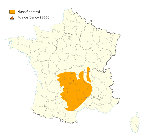
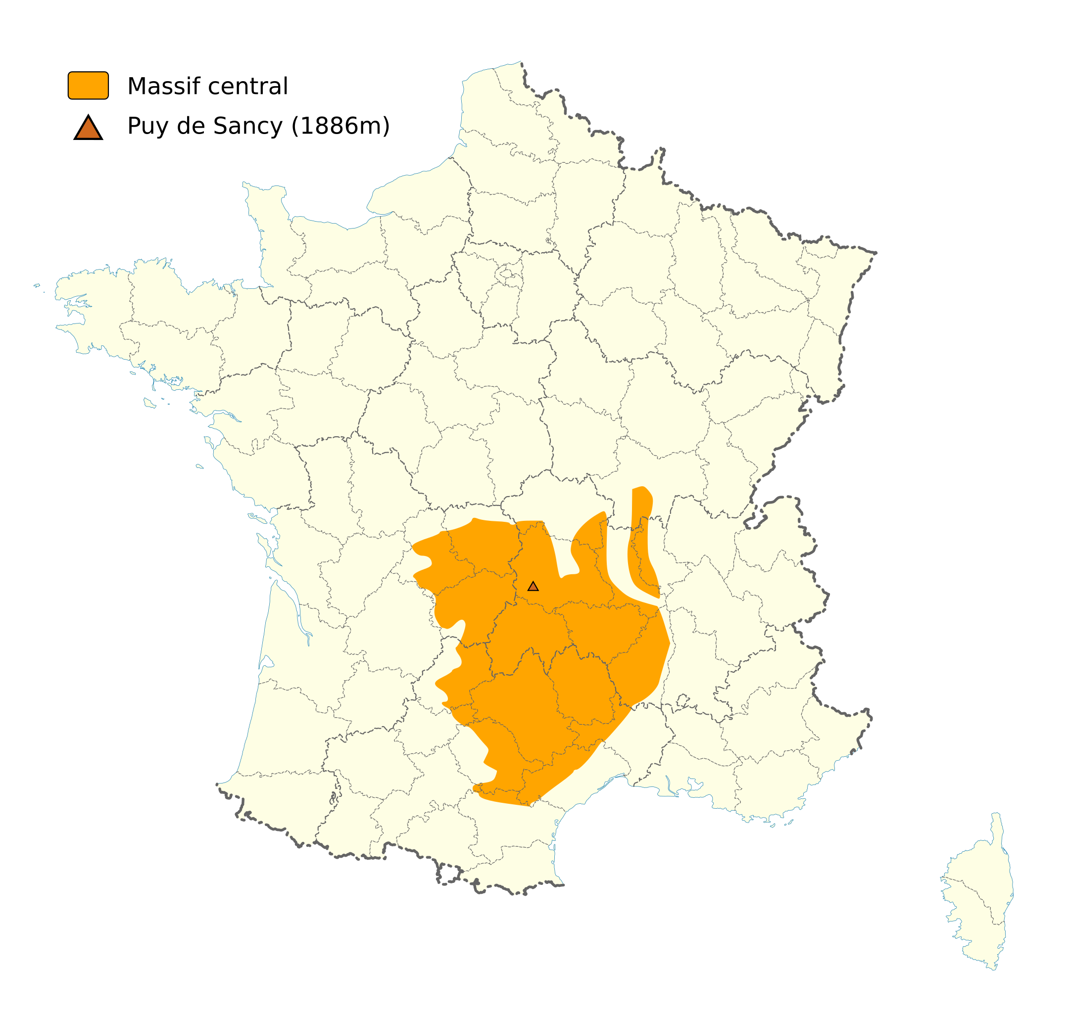
English: France map showing the location of the "Massif central".
Français : Carte de la France montrant l'emplacement du Massif central. |
| Date | (UTC) |
| Source | |
| Author |
|
| Other versions | Image:Massif_Central.PNG |
| This is a retouched picture, which means that it has been digitally altered from its original version. Modifications: Removed coordinates and surrounding countries, and added "Massif central" location. The original can be viewed here: France map Lambert-93 with regions and departments-blank.svg:
|
This W3C-unspecified vector image was created with Inkscape .
I, the copyright holder of this work, hereby publish it under the following licenses:
This file is licensed under the Creative Commons Attribution-Share Alike 3.0 Unported, 2.5 Generic, 2.0 Generic and 1.0 Generic license.
- You are free:
- to share – to copy, distribute and transmit the work
- to remix – to adapt the work
- Under the following conditions:
- attribution – You must give appropriate credit, provide a link to the license, and indicate if changes were made. You may do so in any reasonable manner, but not in any way that suggests the licensor endorses you or your use.
- share alike – If you remix, transform, or build upon the material, you must distribute your contributions under the same or compatible license as the original.
You may select the license of your choice.
Original upload log
[edit]
This image is a derivative work of the following images:
- Image:France_map_Lambert-93_with_regions_and_departments-blank.svg licensed with Cc-by-sa-3.0,2.5,2.0,1.0, Cc-by-sa-3.0,2.5,2.0,1.0
- 2008-11-13T17:38:21Z Sting 2000x1898 (885358 Bytes) + boundary for Channel Islands
- 2008-10-01T04:50:15Z Sting 2000x1898 (883528 Bytes) == Summary == {{Location|46|15|00|N|02|06|00|E|scale:10000000}} {{Information |Description={{en|Blank map of [[:en:France|France]] in the official Lambert-93 projection, with regions and departments boundaries.}} {{fr|Carte
Uploaded with derivativeFX
File history
Click on a date/time to view the file as it appeared at that time.
| Date/Time | Thumbnail | Dimensions | User | Comment | |
|---|---|---|---|---|---|
| current | 13:38, 7 May 2024 | | 2,000 × 1,898 (449 KB) | Jack ma (talk | contribs) | Updated regions limits |
| 13:19, 27 December 2008 |  | 2,000 × 1,898 (500 KB) | Tryphon (talk | contribs) | Hopefully fixed the problem that prevented the image to be rendered to PNG. | |
| 00:43, 27 November 2008 |  | 2,000 × 1,898 (502 KB) | Tryphon (talk | contribs) | {{Information |Description={{en|France map showing the location of the "Massif central".}} {{fr|Carte de la France montrant l'emplacement du Massif central.}} |Source=*Image:France_map_Lambert-93_with_regions_and_departments-blank.svg |Date=2008-11- |
You cannot overwrite this file.
File usage on Commons
The following page uses this file:
File usage on other wikis
The following other wikis use this file:
- Usage on da.wikipedia.org
- Usage on eu.wikipedia.org
- Usage on fr.wikipedia.org
- Massif central
- Puy des Goules
- Puy de la Vache
- Puy de Lassolas
- Bidon (Ardèche)
- Guéry
- Puy de Montiroir
- Col des Sauvages
- Bassin de Brive
- Lemmet
- Col du Tracol
- Col de la Ventouse
- Col de la Moreno
- Lac de la Roucarié
- Croix de Cheules
- Barrage du Piney
- Barrage du Gouffre d'Enfer
- Barrage du Pas-du-Riot
- Catégorie:Wikipédia:ébauche Massif central
- Le Mont-Dore (station de sports d'hiver)
- Prabouré
- Association pour le développement industriel et économique du Massif central
- Céréales Vallée
- Économie du Massif central
- Innoviandes
- Causses du Quercy
- Plein la bobine
- Monts du Vivarais
- Cascades de Gimel
- Causse de Martel
- Réserve naturelle régionale du domaine de Gioux
- Réserve naturelle régionale Vallée de la Vienne « Chez Roger »
- Roc Blanc
- Puy de Montoncel
- Mont Monet
- Le Champ de Mars (sommet)
- Laguiole - Le Bouyssou
- Pic d'Anjeau
- Col du Cheval Mort
- Terrefort rouergat
- Foufouilloux
- Monts de Fayat
- Plateau du Limousin
- Neck de Sceautres
- Mont Aigu
- Monts de Guéret
- Sommet de Méjan
- Rocher d'Abraham
View more global usage of this file.