File:Mawrth Vallis martian mosaic.jpg

Original file (4,000 × 5,974 pixels, file size: 2.98 MB, MIME type: image/jpeg)
Captions
Captions
Summary
[edit]
| Description |
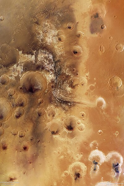
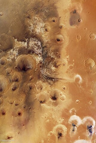
English: Sculpted by ancient water flowing on the surface, Mawrth Vallis is one of the most remarkable outflow channels on Mars. The valley, once a potentially habitable place, is one of the main features of a region at the boundary between the southern highlands and the northern lowlands.
Mawrth Vallis takes centre stage in this image, a bird’s eye view of a 330 000 sq km area surrounding the valley. With a length of 600 km and a depth of up to 2 km, it is one of the biggest valleys on Mars. Huge amounts of water once passed through it, from a higher elevation region, part of which is shown in the lower right of the image, into the northern plains, in the top left. Among the remarkable features are the large exposures of light-toned phyllosilicates (weathered clay minerals) that lie along its course. Phyllosilicates on Mars are evidence of the past presence of liquid water and point to the possibility that habitable environments could have existed on the planet up until 3.6 billion years ago. A dark cap rock, remains of ancient volcanic ash, covers many of the clays and could have protected traces of ancient microbes in the rocks from radiation and erosion. This makes Mawrth Vallis one of the most interesting regions for geologists and astrobiologists alike. It is one of the candidate landing sites for ExoMars 2020, a joint mission between ESA and Russia, with the primary goal of finding out if life once existed on Mars. The name comes from the Welsh word for Mars (“Mawrth”) and the Latin for valley (“Vallis”). This mosaic was created using nine individual images taken by the high-resolution stereo camera on ESA’s Mars Express spacecraft, which has been orbiting Mars since late 2003. It is one of a set of images of this region previously published on 7 July 2016 on the DLR website and the homepage of the Freie Universität Berlin.Русский: Долина Мавра на Марсе, просторы долины с каналом, длина которого составляет около 600 км, а глубина - около 2 км. |
| Date | |
| Source | http://www.esa.int/spaceinimages/Images/2016/09/Mawrth_Vallis_martian_mosaic |
| Author | ESA/DLR/FU Berlin |
Licensing
[edit]
This media was created by the European Space Agency (ESA).
Where expressly so stated, images or videos are covered by the Creative Commons Attribution-ShareAlike 3.0 IGO (CC BY-SA 3.0 IGO) licence, ESA being an Intergovernmental Organisation (IGO), as defined by the CC BY-SA 3.0 IGO licence. The user is allowed under the terms and conditions of the CC BY-SA 3.0 IGO license to Reproduce, Distribute and Publicly Perform the ESA images and videos released under CC BY-SA 3.0 IGO licence and the Adaptations thereof, without further explicit permission being necessary, for as long as the user complies with the conditions and restrictions set forth in the CC BY-SA 3.0 IGO licence, these including that:
See the ESA Creative Commons copyright notice for complete information, and this article for additional details.
|
 | |
This file is licensed under the Creative Commons Attribution-ShareAlike 3.0 IGO license. Attribution: ESA/DLR/FU Berlin, CC BY-SA IGO 3.0
| ||
| This media has been released under a free license by the Deutsches Zentrum für Luft- und Raumfahrt (DLR). Their website states: "Where expressly stated, DLR images and videos are covered by a Creative Commons Attribution 3.0 Germany (CC BY 3.0) licence. This licence grants permission to reproduce or distribute the work, to make the work and/or its contents publically available, to alter or edit the work and/or its contents and to make commercial use of the work, provided that you explicitly mention DLR as its source in a clearly legible format. Examples: 'Photo: DLR, CC-BY 3.0', 'Images: DLR, CC-BY 3.0', 'Video: DLR, CC-BY 3.0'." To the uploader: You must provide a link (URL) to the original file and the authorship information if available. |
- You are free:
- to share – to copy, distribute and transmit the work
- to remix – to adapt the work
- Under the following conditions:
- attribution – You must give appropriate credit, provide a link to the license, and indicate if changes were made. You may do so in any reasonable manner, but not in any way that suggests the licensor endorses you or your use.

File history
Click on a date/time to view the file as it appeared at that time.
| Date/Time | Thumbnail | Dimensions | User | Comment | |
|---|---|---|---|---|---|
| current | 23:55, 11 February 2023 | | 4,000 × 5,974 (2.98 MB) | Don-vip (talk | contribs) | high-res from dlr |
| 06:48, 12 December 2016 |  | 1,500 × 2,189 (4.39 MB) | Samsara (talk | contribs) | cropped to remove watermark, and moved scale to preserve it | |
| 11:53, 9 December 2016 |  | 1,500 × 2,240 (4.51 MB) | JukoFF (talk | contribs) | User created page with UploadWizard |
You cannot overwrite this file.
File usage on Commons
The following 6 pages use this file:
.jpeg&redirect=no)
File usage on other wikis
The following other wikis use this file:
- Usage on ca.wikipedia.org
- Usage on de.wikipedia.org
- Usage on en.wikipedia.org
- Usage on es.wikipedia.org
- Usage on hu.wikipedia.org
- Usage on it.wikipedia.org
- Usage on pl.wikipedia.org
- Usage on ru.wikipedia.org
- Usage on www.wikidata.org