File:Mer Noire (carte).png
Jump to navigation
Jump to search
Size of this preview: 787 × 600 pixels. Other resolutions: 315 × 240 pixels | 630 × 480 pixels | 1,008 × 768 pixels.
Original file (1,008 × 768 pixels, file size: 301 KB, MIME type: image/png)
Captions
Captions
Add a one-line explanation of what this file represents
| Description |
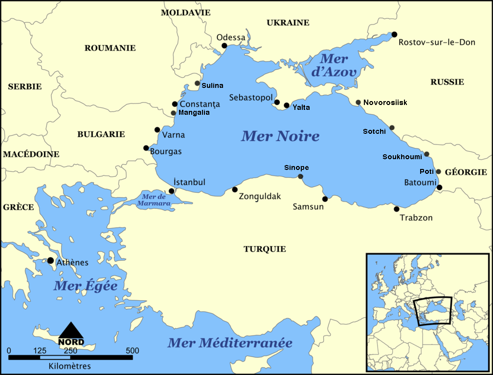
Français : carte de la mer Noire et de la mer d'Azov et leurs principales villes côtières. |
| Date |
Français : février 2007 |
| Source |
This file was derived from: Black Sea map.png: |
| Author |
Français : carte francisée par Idarvol |
| Other versions |
[]
Derivative works of this file: |


.png)


|
Permission is granted to copy, distribute and/or modify this document under the terms of the GNU Free Documentation License, Version 1.2 or any later version published by the Free Software Foundation; with no Invariant Sections, no Front-Cover Texts, and no Back-Cover Texts. A copy of the license is included in the section entitled GNU Free Documentation License. |
| This file is licensed under the Creative Commons Attribution-Share Alike 3.0 Unported license. | ||
| ||
| This licensing tag was added to this file as part of the GFDL licensing update. |
File history
Click on a date/time to view the file as it appeared at that time.
| Date/Time | Thumbnail | Dimensions | User | Comment | |
|---|---|---|---|---|---|
| current | 10:16, 23 February 2013 | | 1,008 × 768 (301 KB) | Spiridon Ion Cepleanu (talk | contribs) | More harbours |
| 21:38, 18 February 2007 |  | 1,200 × 914 (352 KB) | Idarvol (talk | contribs) | {{fr|<br /> *'''Titre''' : carte de la mer Noire *'''Description''' : carte de la mer Noire et de la mer d'Azov et leurs principales villes côtières. *'''Source''' : Image:Black Sea map.png de NormanEinstein *'''Date''' : février 2007 *'''Auteurs' |
You cannot overwrite this file.
File usage on Commons
The following 19 pages use this file:
- User:Idarvol/Galerie
- File:Black Sea map-ar.png
- File:Black Sea map-de.png
- File:Black Sea map-sv.png
- File:Black Sea map-tr.png
- File:Black Sea map-zh.png
- File:Black Sea map.png
- File:Black Sea map blank.png
- File:Black Sea map he.png
- File:Black Sea map he (cropped).png
- File:Black Sea map hr.svg
- File:Black Sea map ku.png
- File:Black Sea map lld.png
- File:Black Sea map ta.png
- File:Mer Noire (carte).png
- File:Morze Czarne mapa pl.png
- File:Zwarte Zee.png
- File:ΜαύρηΘάλασσα.PNG
- Template:Other versions/Black Sea map
.png)
File usage on other wikis
The following other wikis use this file:
- Usage on an.wikipedia.org
- Usage on ar.wikipedia.org
- Usage on br.wikipedia.org
- Usage on en.wiktionary.org
- Usage on es.wikibooks.org
- Usage on fr.wikipedia.org
- Usage on fr.wikinews.org
- Usage on fr.wiktionary.org
- Usage on gd.wikipedia.org
- Usage on lad.wikipedia.org
- Usage on ro.wikipedia.org
.png&oldid=852491305)