File:MerdeBeaufort.png
Jump to navigation
Jump to search
No higher resolution available.
MerdeBeaufort.png (495 × 455 pixels, file size: 134 KB, MIME type: image/png)
Captions
Captions
Add a one-line explanation of what this file represents
Summary
[edit]
| Description |
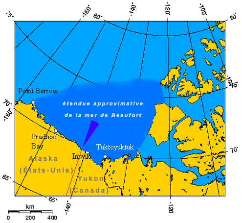
Français : La mer de Beaufort et les mers disputées. English: The wedge shaped area on this map is the approximate area of the waters in dispute between the Yukon and Alaska. The longitude and latitudes of the communities follow:
|
| Source | Secondary source: http://en.wikipedia.org/wiki/Image:Beaufort_Sea_and_disputed_waters.png |
| Author | |
| Permission (Reusing this file) |
Copyright owner: Geo Swan |
Licensing
[edit]
| This file is licensed under the Creative Commons Attribution-Share Alike 3.0 Unported license. Subject to disclaimers. | ||
| ||
| This licensing tag was added to this file as part of the GFDL licensing update. |

|
Permission is granted to copy, distribute and/or modify this document under the terms of the GNU Free Documentation License, Version 1.2 or any later version published by the Free Software Foundation; with no Invariant Sections, no Front-Cover Texts, and no Back-Cover Texts. A copy of the license is included in the section entitled GNU Free Documentation License. Subject to disclaimers. |
File history
Click on a date/time to view the file as it appeared at that time.
| Date/Time | Thumbnail | Dimensions | User | Comment | |
|---|---|---|---|---|---|
| current | 14:51, 4 June 2006 | | 495 × 455 (134 KB) | Sting (talk | contribs) | + scale |
| 13:00, 4 June 2006 |  | 495 × 445 (132 KB) | Sting (talk | contribs) | Translation in French | |
| 21:03, 28 May 2006 |  | 510 × 600 (165 KB) | Chris93 (talk | contribs) | Carte en attente de traduction. La mer de Beaufort et les mers disputées. The wedge shaped area on this map is the approximate area of the waters in dispute between the Yukon and Alaska. The longitude and latitudes of the communities follow: * -148.4 |
You cannot overwrite this file.
File usage on Commons
There are no pages that use this file.
File usage on other wikis
The following other wikis use this file:
- Usage on fr.wikipedia.org
- Usage on it.wikipedia.org
- Usage on ro.wikipedia.org
- Usage on sw.wikipedia.org
- Usage on tr.wikipedia.org