File:Meyers b11 s0553a.jpg
Jump to navigation
Jump to search
Size of this preview: 800 × 498 pixels. Other resolutions: 320 × 199 pixels | 640 × 398 pixels | 1,024 × 637 pixels | 1,280 × 796 pixels | 2,360 × 1,468 pixels.
Original file (2,360 × 1,468 pixels, file size: 4.19 MB, MIME type: image/jpeg)
Captions
Captions
Add a one-line explanation of what this file represents
Summary
[edit]
| Description |
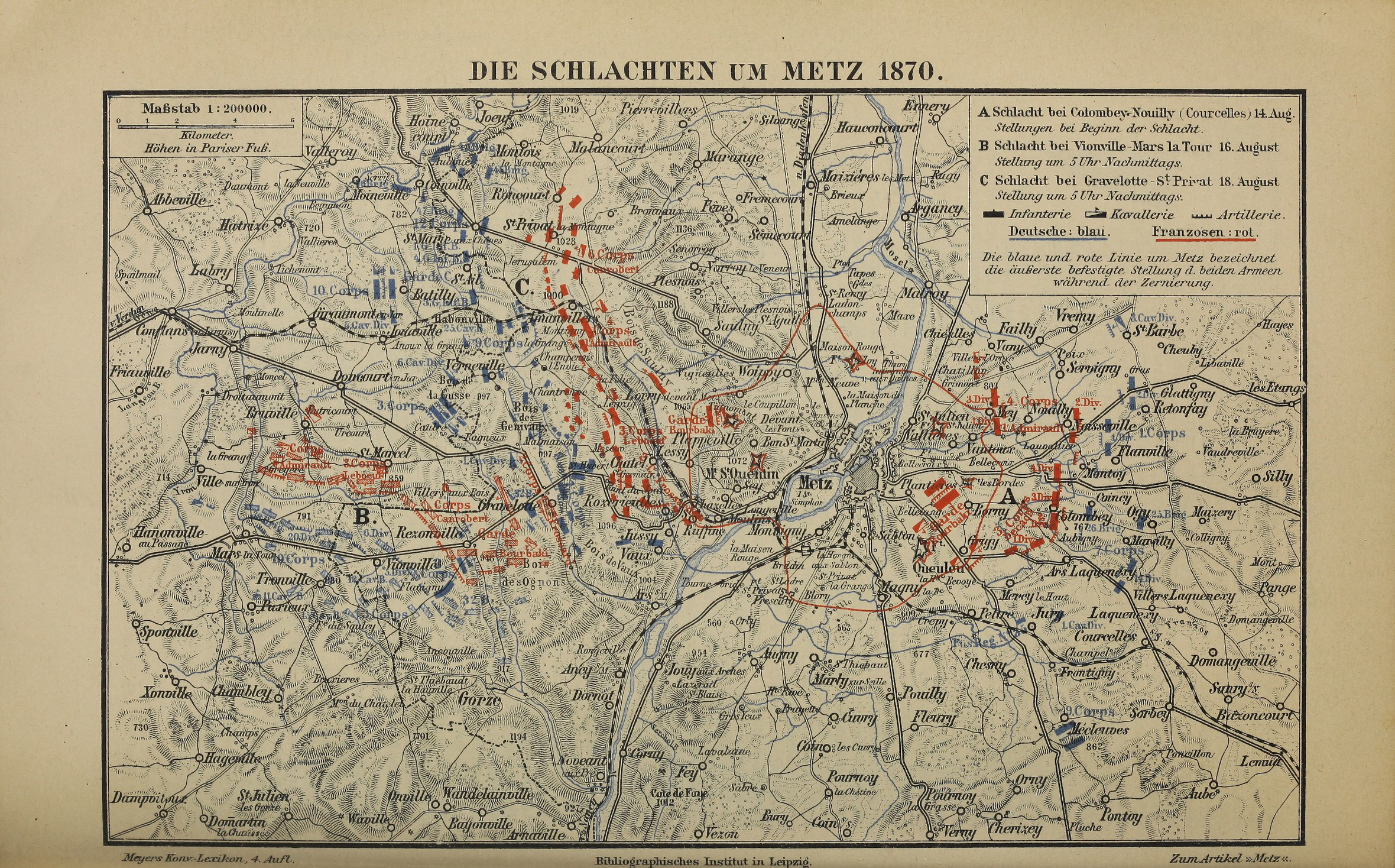
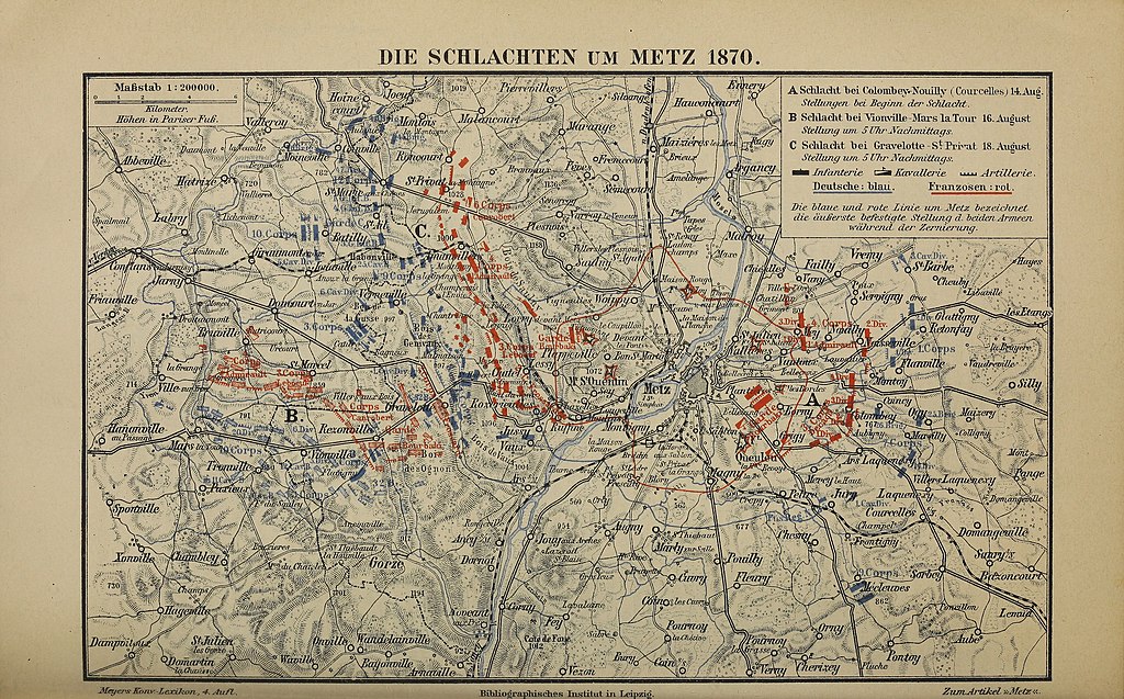
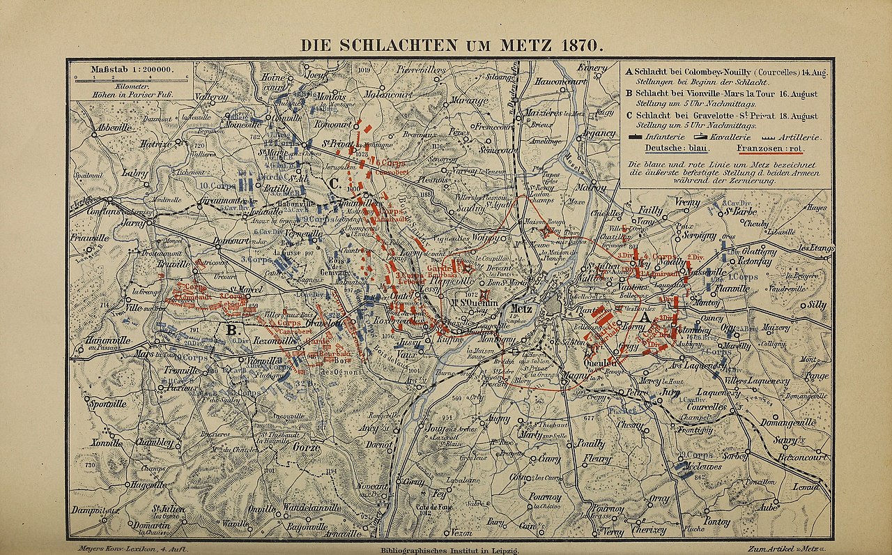
Deutsch: Karte „Die Schlachten um Metz 1870“. Original-Text der Legende: Maßstab 1 : 200 000. Höhen in Pariser Fuß. – A Schlacht bei Colombey-Nouilly (Courcelles) 14. Aug. Stellungen bei Beginn der Schlacht. – B Schlacht bei Vionville-Mars la Tour 16. August Stellung um 5 Uhr Nachmittags. – C Schlacht bei Gravelott-St. Privat 18. August Stellung um 5 Uhr Nachmittags. – Deutsche: blau. – Franzosen: rot. – Die blaue und rote Linie um Metz bezeichnet die äußerste befestigte Stellung d. beiden Armeen während der Zernierung. – Zum Artikel „Metz“ |
| Date | from 1885 until 1890 |
| Source | vol. 11 of the 4th edition of Meyers Konversations-Lexikon – Internet Archive identifier: meyerskonversati11meye |
| Author | various |
Licensing
[edit]
This page comes from Book 11 of the 4th edition of Meyers Konversationslexikon (1885–90). The copyrights for that book have expired and this page is in the public domain.
|
This work is in the public domain in the United States because it was published (or registered with the U.S. Copyright Office) before January 1, 1929.
Public domain works must be out of copyright in both the United States and in the source country of the work in order to be hosted on the Commons. If the work is not a U.S. work, the file must have an additional copyright tag indicating the copyright status in the source country.
Note: This tag should not be used for sound recordings. |
File history
Click on a date/time to view the file as it appeared at that time.
| Date/Time | Thumbnail | Dimensions | User | Comment | |
|---|---|---|---|---|---|
| current | 19:17, 13 December 2021 | | 2,360 × 1,468 (4.19 MB) | Mapmarks (talk | contribs) | better quality |
| 14:53, 1 August 2015 |  | 2,494 × 1,602 (4.79 MB) | Mapmarks (talk | contribs) | == {{int:filedesc}} == {{Information |description={{de|1=Karte „Die Schlachten um Metz 1870“. Original-Text der Legende: ''Maßstab {{nowrap|1 : 200 000.}} Höhen in Pariser Fuß. – A Schlacht bei Colombey-Nouilly (Courcelles) 14. Aug. Stellungen... |
You cannot overwrite this file.
File usage on Commons
The following page uses this file:
File usage on other wikis
The following other wikis use this file:
- Usage on de.wikisource.org