File:Moldova harta administrativa.png
Jump to navigation
Jump to search

Size of this preview: 484 × 600 pixels. Other resolutions: 194 × 240 pixels | 387 × 480 pixels | 620 × 768 pixels | 826 × 1,024 pixels | 1,402 × 1,737 pixels.
Original file (1,402 × 1,737 pixels, file size: 582 KB, MIME type: image/png)
Captions
Captions
Add a one-line explanation of what this file represents
Summary
[edit]| Description |
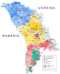
English: Administrative map of Moldova |
| Source | Own work |
| Author | Andrein |
| Other versions |
Derivative works of this file: A Moldáv Köztársaság közigazgatási felosztása.PNG
|


Licensing
[edit]
I, the copyright holder of this work, hereby publish it under the following licenses:

|
Permission is granted to copy, distribute and/or modify this document under the terms of the GNU Free Documentation License, Version 1.2 or any later version published by the Free Software Foundation; with no Invariant Sections, no Front-Cover Texts, and no Back-Cover Texts. A copy of the license is included in the section entitled GNU Free Documentation License. |
This file is licensed under the Creative Commons Attribution-Share Alike 4.0 International, 3.0 Unported, 2.5 Generic, 2.0 Generic and 1.0 Generic license.
- You are free:
- to share – to copy, distribute and transmit the work
- to remix – to adapt the work
- Under the following conditions:
- attribution – You must give appropriate credit, provide a link to the license, and indicate if changes were made. You may do so in any reasonable manner, but not in any way that suggests the licensor endorses you or your use.
- share alike – If you remix, transform, or build upon the material, you must distribute your contributions under the same or compatible license as the original.
You may select the license of your choice.
File history
Click on a date/time to view the file as it appeared at that time.
| Date/Time | Thumbnail | Dimensions | User | Comment | |
|---|---|---|---|---|---|
| current | 17:08, 14 October 2014 | | 1,402 × 1,737 (582 KB) | Spiridon Ion Cepleanu (talk | contribs) | Add the limits of the raions of the left bank of the Dniestr |
| 23:25, 3 April 2012 |  | 1,402 × 1,737 (585 KB) | ArdadN (talk | contribs) | 1 | |
| 03:26, 23 October 2011 |  | 1,402 × 1,737 (588 KB) | ArdadN (talk | contribs) | 1 | |
| 18:36, 21 October 2011 |  | 1,402 × 1,737 (588 KB) | ArdadN (talk | contribs) | 1 | |
| 18:17, 21 October 2011 |  | 1,402 × 1,737 (585 KB) | ArdadN (talk | contribs) | update | |
| 19:11, 25 October 2010 |  | 1,402 × 1,737 (523 KB) | Владимир А. (talk | contribs) | No municipality Tighina in Moldova. There is municipality Bendery. | |
| 21:55, 3 September 2009 |  | 1,402 × 1,737 (530 KB) | ArdadN (talk | contribs) | 1 | |
| 17:31, 7 May 2009 |  | 1,402 × 1,737 (527 KB) | ArdadN (talk | contribs) | 1 | |
| 17:27, 7 May 2009 |  | 1,402 × 1,737 (525 KB) | ArdadN (talk | contribs) | 1 | |
| 14:03, 20 April 2009 |  | 1,402 × 1,737 (480 KB) | Olahus (talk | contribs) | Even in Moldova, Romania is spelled "România", not "Romînia". They just use the old Romanian spelling. |
You cannot overwrite this file.
File usage on Commons
The following 90 pages use this file:
- Atlas of Moldova
- File:A Moldáv Köztársaság közigazgatási felosztása.PNG
- File:Anenii Noi in Moldova.svg
- File:Anenii Noi in Moldova (semi-secession).svg
- File:Balti in Moldova.svg
- File:Balti in Moldova (semi-secession).svg
- File:Basarabeasca in Moldova.svg
- File:Basarabeasca in Moldova (semi-secession).svg
- File:Bender in Moldova.svg
- File:Bender in Moldova (breakaway hatched).svg
- File:Bender in Moldova (semi-secession).svg
- File:Briceni in Moldova.svg
- File:Briceni in Moldova (semi-secession).svg
- File:Cahul in Moldova.svg
- File:Cahul in Moldova (semi-secession).svg
- File:Calarasi in Moldova.svg
- File:Calarasi in Moldova (semi-secession).svg
- File:Cantemir in Moldova.svg
- File:Cantemir in Moldova (semi-secession).svg
- File:Causeni in Moldova.svg
- File:Causeni in Moldova (breakaway hatched).svg
- File:Causeni in Moldova (semi-secession).svg
- File:Chisinau in Moldova (city + district hatched).svg
- File:Chisinau in Moldova (city + surroundings hatched) (semi-secession).svg
- File:Chisinau in Moldova (city only).svg
- File:Chisinau in Moldova (city only) (semi-secession).svg
- File:Chisinau in Moldova (district).svg
- File:Chisinau in Moldova (district) (semi-secession).svg
- File:Cimislia in Moldova.svg
- File:Cimislia in Moldova (semi-secession).svg
- File:Criuleni in Moldova.svg
- File:Criuleni in Moldova (semi-secession).svg
- File:Donduseni in Moldova.svg
- File:Donduseni in Moldova (semi-secession).svg
- File:Drochia in Moldova.svg
- File:Drochia in Moldova (semi-secession).svg
- File:Dubasari in Moldova.svg
- File:Dubasari in Moldova (semi-secession).svg
- File:Edinet in Moldova.svg
- File:Edinet in Moldova (semi-secession).svg
- File:Falesti in Moldova.svg
- File:Falesti in Moldova (semi-secession).svg
- File:Floresti in Moldova.svg
- File:Floresti in Moldova (semi-secession).svg
- File:Gagauzia in Moldova.svg
- File:Gagauzia in Moldova (semi-secession).svg
- File:Glodeni in Moldova.svg
- File:Glodeni in Moldova (semi-secession).svg
- File:Harta administrativa a Republicii Moldova.jpg
- File:Hincesti in Moldova.svg
- File:Hincesti in Moldova (semi-secession).svg
- File:Ialoveni in Moldova.svg
- File:Ialoveni in Moldova (semi-secession).svg
- File:Leova in Moldova.svg
- File:Leova in Moldova (semi-secession).svg
- File:Moldova administrative map.png
- File:Moldova administrative map.svg
- File:Moldova harta administrativa.svg
- File:Nisporeni in Moldova.svg
- File:Nisporeni in Moldova (semi-secession).svg
- File:Ocnita in Moldova.svg
- File:Ocnita in Moldova (semi-secession).svg
- File:Orhei in Moldova.svg
- File:Orhei in Moldova (semi-secession).svg
- File:Rezina in Moldova.svg
- File:Rezina in Moldova (semi-secession).svg
- File:Riscani in Moldova.svg
- File:Riscani in Moldova (semi-secession).svg
- File:Singerei in Moldova.svg
- File:Singerei in Moldova (semi-secession).svg
- File:Soldanesti in Moldova.svg
- File:Soldanesti in Moldova (semi-secession).svg
- File:Soroca in Moldova.svg
- File:Soroca in Moldova (semi-secession).svg
- File:Stefan Voda in Moldova.svg
- File:Stefan Voda in Moldova (semi-secession).svg
- File:Straseni in Moldova.svg
- File:Straseni in Moldova (semi-secession).svg
- File:Taraclia District in Moldova.svg
- File:Taraclia in Moldova (semi-secession).svg
- File:Telenesti in Moldova.svg
- File:Telenesti in Moldova (semi-secession).svg
- File:Transnistria in Moldova (de-facto).svg
- File:Transnistria in Moldova (de-facto) (semi-secession).svg
- File:Transnistria in Moldova (de-facto hatched).svg
- File:Transnistria in Moldova (de-facto only hatched).svg
- File:Transnistria in Moldova (de-jure).svg
- File:Transnistria in Moldova (de-jure) (semi-secession).svg
- File:Ungheni in Moldova.svg
- File:Ungheni in Moldova (semi-secession).svg
.svg)
.svg)
.svg)
.svg)
.svg)
.svg)
.svg)
.svg)
.svg)
.svg)
.svg)
.svg)
_(semi-secession).svg)
.svg)
_(semi-secession).svg)
.svg)
_(semi-secession).svg)
.svg)
.svg)
.svg)
.svg)
.svg)
.svg)
.svg)
.svg)
.svg)
.svg)
.svg)
.svg)
.svg)
.svg)
.svg)
.svg)
.svg)
.svg)
.svg)
.svg)
.svg)
.svg)
.svg)
.svg)
.svg)
.svg)
_(semi-secession).svg)
.svg)
.svg)
.svg)
_(semi-secession).svg)
.svg)
File usage on other wikis
The following other wikis use this file:
- Usage on be-tarask.wikipedia.org
- Usage on be.wikipedia.org
- Usage on bs.wikipedia.org
- Usage on ca.wikipedia.org
- Usage on en.wikipedia.org
- Usage on es.wikipedia.org
- Usage on fa.wikipedia.org
- Usage on he.wikipedia.org
- Usage on id.wikipedia.org
- Usage on ja.wikipedia.org
- Usage on krc.wikipedia.org
- Usage on mk.wikipedia.org
- Usage on pl.wikipedia.org
- Usage on pt.wikipedia.org
- Usage on ro.wikipedia.org
- Usage on ur.wikipedia.org
- Usage on wuu.wikipedia.org