File:Níjar-loc.svg
Jump to navigation
Jump to search

Size of this PNG preview of this SVG file: 512 × 469 pixels. Other resolutions: 262 × 240 pixels | 524 × 480 pixels | 838 × 768 pixels | 1,118 × 1,024 pixels | 2,236 × 2,048 pixels.
Original file (SVG file, nominally 512 × 469 pixels, file size: 347 KB)
Captions
Captions
Add a one-line explanation of what this file represents
Summary
[edit]
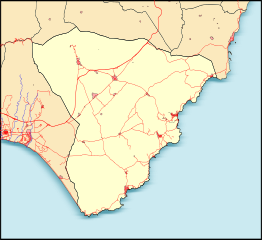
| Description | Mapa de localización del términomunicipal de Níjar (Almería-España) | |
| Date | ||
| Source | Own work | |
| Author | Miguillen | |
| SVG development | This locator map was created with Inkscape.
|
Licensing
[edit]
I, the copyright holder of this work, hereby publish it under the following licenses:

|
Permission is granted to copy, distribute and/or modify this document under the terms of the GNU Free Documentation License, Version 1.2 or any later version published by the Free Software Foundation; with no Invariant Sections, no Front-Cover Texts, and no Back-Cover Texts. A copy of the license is included in the section entitled GNU Free Documentation License. |
This file is licensed under the Creative Commons Attribution-Share Alike 4.0 International, 3.0 Unported, 2.5 Generic, 2.0 Generic and 1.0 Generic license.
- You are free:
- to share – to copy, distribute and transmit the work
- to remix – to adapt the work
- Under the following conditions:
- attribution – You must give appropriate credit, provide a link to the license, and indicate if changes were made. You may do so in any reasonable manner, but not in any way that suggests the licensor endorses you or your use.
- share alike – If you remix, transform, or build upon the material, you must distribute your contributions under the same or compatible license as the original.
You may select the license of your choice.
File history
Click on a date/time to view the file as it appeared at that time.
| Date/Time | Thumbnail | Dimensions | User | Comment | |
|---|---|---|---|---|---|
| current | 17:09, 24 June 2010 | | 512 × 469 (347 KB) | Miguillen (talk | contribs) | {{Information |Description=Mapa de localización del términomunicipal de Níjar (Almería-España) |Source={{own}} |Date=2010-06-14 |Author=Miguillen |Permission= |other_versions= }} {{Taller de Cartografía}} [[Category |
You cannot overwrite this file.
File usage on Commons
There are no pages that use this file.
File usage on other wikis
The following other wikis use this file:
- Usage on eo.wikipedia.org
- Usage on es.wikipedia.org
- Níjar
- Rodalquilar
- San Isidro de Níjar
- Huebro
- Las Negras
- Agua Amarga
- Pozo de los Frailes
- Albaricoques (Almería)
- Los Escullos
- Ensenada de Mónsul
- Cala del Plomo
- Playazo de Rodalquilar
- Playa del Arco
- Playa de los Genoveses
- Playa del Peñón Blanco
- Cala de San Pedro (Níjar)
- Cala de Enmedio
- Cala de la Polacra
- Cala del Príncipe
- Ensenada de la Media Luna
- Las Hortichuelas
- Fernán Pérez (Almería)
- Presillas Bajas
- La Fabriquilla
- Cerro del Fraile
- Plantilla:Mapa de localización de Níjar
- Cala Arena
- Faro del Cabo de Gata
- Usage on hy.wikipedia.org