File:NATO enlargement.svg
Jump to navigation
Jump to search

Size of this PNG preview of this SVG file: 778 × 599 pixels. Other resolutions: 312 × 240 pixels | 623 × 480 pixels | 997 × 768 pixels | 1,280 × 986 pixels | 2,560 × 1,972 pixels | 897 × 691 pixels.
Original file (SVG file, nominally 897 × 691 pixels, file size: 439 KB)
Captions
Captions
Add a one-line explanation of what this file represents
Summary
[edit]
| Description |
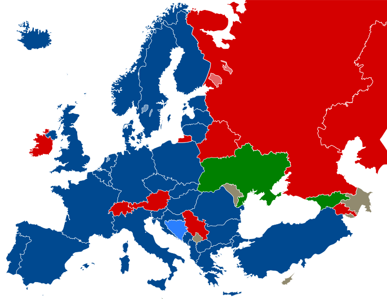
English: Map of European relationships with the North Atlantic Treaty Organization (NATO) through 2022. Member areas not included in the map include the United States, Canada, Greenland, and French Guiana.Updated map available.
==Colors== Current members countries which are undergoing application process Membership Action Plan countries Promised invitation Membership not goal Undeclared intent Deutsch: Karte der europäischen Beziehungen zur Nordatlantikpakt-Organisation (NATO) bis 2022. Mitgliedsgebiete, die nicht in der Karte enthalten sind, umfassen die Vereinigten Staaten, Kanada, Grönland und Französisch-Guayana. Aktualisierte Karte verfügbar.
==Farben== Mitgliedstaaten Staaten, die sich im Beitrittsprozess befinden Beitrittskandidaten (MAP) Versprochene Einladung Intensiver Dialog Kein Beitritt geplant Haltung zum Beitritt unbekannt Français : Carte des relations européennes avec l'Organisation du Traité de l'Atlantique Nord (OTAN) jusqu'en 2022. Les territoires membres non inclus dans la carte incluent les États-Unis, le Canada, le Groenland et la Guyane française. Carte mise à jour disponible.
==Couleurs== États membres États en voie d'adhésion Invitation promise Pas d'adhésion prévue Attitude envers l'adhésion inconnue Español: Mapa de las relaciones europeas con la Organización del Tratado del Atlántico Norte (OTAN) hasta 2022. Los territorios miembros no incluidos en el mapa incluyen Estados Unidos, Canadá, Groenlandia y la Guayana Francesa. Mapa actualizado disponible.
==Colores== Países miembros Países en proceso de adhesión Invitación prometida Sin unión prevista Actitud hacia la adhesión desconocida Português: Mapa das relações europeias com a Organização do Tratado do Atlântico Norte (OTAN) até 2022. Os territórios membros não incluídos no mapa incluem Estados Unidos, Canadá, Groenlândia e Guiana Francesa. Mapa atualizado disponível. ==Colores== Países Membros Países em processo de adesão Promessa de Adesão Filiação não é objetivo Intenção não declarada |
| Date | |
| Source |
Own work |
| Author | Patrickneil |
| Other versions | NATO affiliations in Europe.svg, and see also NATO expansion.png for enlargement up to 2004 |
| SVG development |
Licensing
[edit]
| I, the copyright holder of this work, release this work into the public domain. This applies worldwide. In some countries this may not be legally possible; if so: I grant anyone the right to use this work for any purpose, without any conditions, unless such conditions are required by law. |
File history
Click on a date/time to view the file as it appeared at that time.
| Date/Time | Thumbnail | Dimensions | User | Comment | |
|---|---|---|---|---|---|
| current | 17:05, 7 March 2024 | | 897 × 691 (439 KB) | Nablicus (talk | contribs) | update (Sweden) |
| 15:31, 3 April 2023 |  | 897 × 691 (439 KB) | Edroeh (talk | contribs) | +FIN | |
| 04:56, 23 July 2022 |  | 897 × 691 (439 KB) | Kwamikagami (talk | contribs) | NATO blue, #004990 | |
| 20:08, 29 June 2022 |  | 897 × 691 (439 KB) | Edroeh (talk | contribs) | Sweden and Finnland are in the ratification process | |
| 02:24, 16 April 2022 |  | 897 × 691 (439 KB) | Edroeh (talk | contribs) | Sweden and Finnland got invitation by NATO to join. | |
| 17:39, 27 March 2020 |  | 897 × 691 (439 KB) | Nablicus (talk | contribs) | update | |
| 18:48, 5 June 2017 |  | 897 × 691 (439 KB) | Avis28 (talk | contribs) | + Montenegro | |
| 02:47, 20 December 2011 |  | 897 × 691 (439 KB) | Patrickneil (talk | contribs) | Reverted to version as of 03:55, 4 December 2011; Looks like that was hasty | |
| 17:26, 17 December 2011 |  | 897 × 691 (494 KB) | Stefan040780 (talk | contribs) | Georgia now offical candidate | |
| 03:55, 4 December 2011 |  | 897 × 691 (439 KB) | J intela (talk | contribs) | Fixed edges |
You cannot overwrite this file.
File usage on Commons
The following 3 pages use this file:
File usage on other wikis
The following other wikis use this file:
- Usage on af.wikipedia.org
- Usage on ar.wikipedia.org
- Usage on bs.wikipedia.org
- Usage on de.wikipedia.org
- NATO
- Diskussion:NATO/Archiv/1
- Diskussion:Annexion der Krim 2014/Archiv/002
- Diskussion:NATO-Osterweiterung/Archiv/1
- NATO-Erweiterung
- Wikipedia:Kartenwerkstatt/Archiv/2022-04
- Benutzer:Alfox/meine Zusammenstellung zu NATO-Osterweiterung
- Wikipedia:Hauptseite/Archiv/28. Januar 2024
- Wikipedia:Hauptseite/Archiv/29. Januar 2024
- Wikipedia:Hauptseite/Archiv/30. Januar 2024
- Usage on en.wikipedia.org
- User:Dangerous-Boy
- Georgia–NATO relations
- Ukraine–NATO relations
- Talk:NATO/Archive 3
- Moldova–NATO relations
- Belarus–NATO relations
- User:Dainomite/Geopolitical interests
- Serbia–NATO relations
- Armenia–NATO relations
- Cyprus–NATO relations
- Austria–NATO relations
- Malta–NATO relations
- Switzerland–NATO relations
- User:Falcaorib/Europe
- Usage on es.wikipedia.org
- Usage on fr.wikipedia.org
- Usage on ga.wikipedia.org
- Usage on hr.wikipedia.org
- Usage on lv.wikipedia.org
- Usage on mk.wikipedia.org
- Usage on nn.wikipedia.org
- Usage on rm.wikipedia.org
- Usage on ru.wikipedia.org
- Usage on sv.wikipedia.org
- Usage on uk.wikipedia.org
- Usage on zea.wikipedia.org