File:Nagorno-Karabakh war map (2020).svg
Jump to navigation
Jump to search

Size of this PNG preview of this SVG file: 667 × 462 pixels. Other resolutions: 320 × 222 pixels | 640 × 443 pixels | 1,024 × 709 pixels | 1,280 × 887 pixels | 2,560 × 1,773 pixels.
Original file (SVG file, nominally 667 × 462 pixels, file size: 972 KB)
Captions
Captions
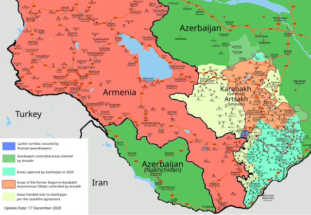
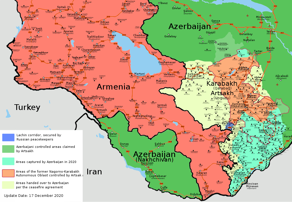
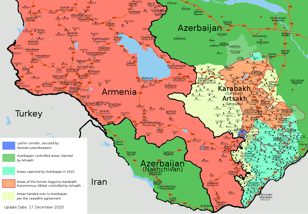
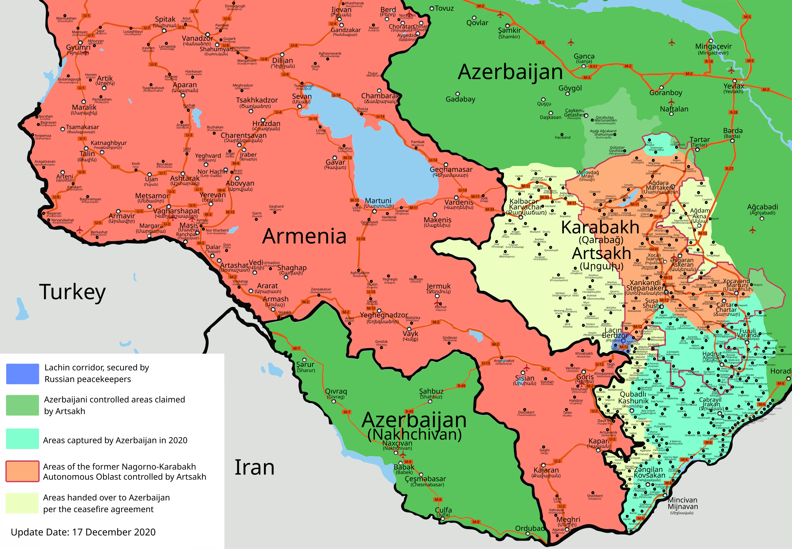
Map of the 2020 Nagorno-Karabakh War
Summary
[edit].svg&action=edit§ion=1)
| Description |
Azərbaycanca: Qarabağ döyüşləri (sentyabr, 2020) xəritəsi Deutsch: Karte des Krieges um Bergkarabach 2020 English: 2020 Nagorno-Karabakh conflict map Español: 2020 Mapa del conflicto de Nagorno-Karabaj Interlingue: Carte del conflicte de Nagorno-Karabakh de 2020 Türkçe: 2020 Dağlık Karabağ çatışmaları haritası Ελληνικά: Χάρτης της σύγκρουσης στο Ναγκόρνο-Καραμπάχ το 2020 فارسی : نقشه درگیری های قره باغ ۲۰۲۰ |
| Date | 2020-10-03, revised and updated in December 2020 |
| Source | Own work |
| Author | Emreculha |
| Other versions |
Derivative works of this file: |
| SVG development |

|
This file may be updated to reflect new information. If you wish to use a specific version of the file without it being overwritten, please upload the required version as a separate file. |
Licensing
[edit].svg&action=edit§ion=2)
I, the copyright holder of this work, hereby publish it under the following license:
This file is licensed under the Creative Commons Attribution-Share Alike 4.0 International license.
- You are free:
- to share – to copy, distribute and transmit the work
- to remix – to adapt the work
- Under the following conditions:
- attribution – You must give appropriate credit, provide a link to the license, and indicate if changes were made. You may do so in any reasonable manner, but not in any way that suggests the licensor endorses you or your use.
- share alike – If you remix, transform, or build upon the material, you must distribute your contributions under the same or compatible license as the original.
Any autoconfirmed user can overwrite this file from the same source. Please ensure that overwrites comply with the guideline.
File history
Click on a date/time to view the file as it appeared at that time.
.svg&dir=prev)
.svg&offset=20201129105030)
.svg&offset=&limit=20)
.svg&offset=&limit=50)
.svg&offset=&limit=100)
.svg&offset=&limit=250)
.svg&offset=&limit=500)
| Date/Time | Thumbnail | Dimensions | User | Comment | |
|---|---|---|---|---|---|
| current | 21:31, 3 February 2021 | | 667 × 462 (972 KB) | GrandEscogriffe (talk | contribs) | File uploaded using svgtranslate tool (https://svgtranslate.toolforge.org/). Added translation for fr. |
| 14:19, 27 December 2020 |  | 667 × 462 (935 KB) | AntonSamuel (talk | contribs) | Minor fixes | |
| 14:28, 21 December 2020 |  | 667 × 462 (934 KB) | AntonSamuel (talk | contribs) | Updates, fixes | |
| 18:57, 17 December 2020 |  | 667 × 462 (897 KB) | Emreculha (talk | contribs) | Çaylaqqala and Köhne Tağlar cede to Azerbaijan (Source BBC MAP: https://www.bbc.com/azeri/azerbaijan-55253513), edits | |
| 14:23, 13 December 2020 |  | 668 × 462 (971 KB) | Robins7 (talk | contribs) | File uploaded using svgtranslate tool (https://svgtranslate.toolforge.org/). Added translation for cs. | |
| 09:38, 8 December 2020 |  | 668 × 462 (939 KB) | AntonSamuel (talk | contribs) | Color changes per talk | |
| 22:14, 6 December 2020 |  | 668 × 462 (937 KB) | AntonSamuel (talk | contribs) | Adding Lachin corridor under Russian peacekeeper control. Fixing some incorrect border markings, Correction: Khtsaberd/Çaylaqqala, Hin Tagher/Köhnə Tağlar & Katarovank under Artsakh control: https://www.civilnet.am/news/2020/12/03/A-Piece-of-Hadrut-Remains-Armenian/411299, https://news.am/eng/news/614981.html, https://caucasus.liveuamap.com/en/2020/27-november-civilnet-anzhelika-zakaryan-says-that-armenians, https://caucasus.liveuamap.com/en/2020/27-november-armenians-still-hold-aylaqqalakhts... | |
| 12:14, 30 November 2020 |  | 668 × 462 (897 KB) | Mastersun25 (talk | contribs) | Reverted to version as of 10:50, 29 November 2020 (UTC) Please make your edits to the latest version of the map | |
| 17:16, 29 November 2020 |  | 668 × 462 (1,008 KB) | Santasa99 (talk | contribs) | Wording which corresponds to wording used in article | |
| 10:50, 29 November 2020 |  | 668 × 462 (897 KB) | Emreculha (talk | contribs) | Minor edits *The Road of Shusha (M-12 it was deleted) *Yuxarı Veyselli |
You cannot overwrite this file.
File usage on Commons
The following 28 pages use this file:
- User:Magog the Ogre/Maps of conflicts/2020 December
- User:Magog the Ogre/Maps of conflicts/2020 November
- User:Magog the Ogre/Maps of conflicts/2020 October
- User:Magog the Ogre/Maps of conflicts/2021 February
- User:Magog the Ogre/Multilingual legend/2020 December 1-10
- User:Magog the Ogre/Multilingual legend/2020 December 11-20
- User:Magog the Ogre/Multilingual legend/2020 December 21-31
- User:Magog the Ogre/Multilingual legend/2020 November 1-10
- User:Magog the Ogre/Multilingual legend/2020 November 11-20
- User:Magog the Ogre/Multilingual legend/2020 November 21-30
- User:Magog the Ogre/Multilingual legend/2021 February 1-9
- User talk:CptViraj/Archive/2020
- Commons:Administrators' noticeboard/Blocks and protections/Archive 28
- Commons:Administrators' noticeboard/User problems/Archive 88
- File:Nagorno-Karabakh war map (2020) (vi).svg
- File:QarabaghWarMap(2020).jpg
- File:QarabaghWarMap(2020).svg (file redirect)
- User talk:CptViraj/Archive/2020
- Commons:Administrators' noticeboard/Blocks and protections/Archive 28
- Commons:Administrators' noticeboard/User problems/Archive 88
- File:QarabaghWarMap(2020).jpg
- User:Magog the Ogre/Maps of conflicts/2020 October
- User:Magog the Ogre/Maps of conflicts/2020 November
- User:Magog the Ogre/Multilingual legend/2020 November 1-10
- User:Magog the Ogre/Multilingual legend/2020 November 11-20
- File talk:2020 Nagorno-Karabakh ceasefire map.svg
- User:Magog the Ogre/Multilingual legend/2020 November 21-30
- File talk:2020 Nagorno-Karabakh ceasefire map.svg
_(vi).svg)
.jpg)
.svg&redirect=no)
File usage on other wikis
The following other wikis use this file:
- Usage on af.wikipedia.org
- Usage on an.wikipedia.org
- Usage on ar.wikipedia.org
- Usage on azb.wikipedia.org
- Usage on be-tarask.wikipedia.org
- Usage on be.wikipedia.org
- Usage on bg.wikipedia.org
- Usage on bn.wikipedia.org
- Usage on ckb.wikipedia.org
- Usage on cs.wikipedia.org
- Usage on cs.wikinews.org
- Usage on cv.wikipedia.org
- Usage on da.wikipedia.org
- Usage on de.wikipedia.org
- Usage on en.wikipedia.org
- User:PubSyr/sandbox
- Talk:Second Nagorno-Karabakh War/Archive 4
- Module:Location map/data/2020 Nagorno-Karabakh conflict map
- Module:Location map/data/2020 Nagorno-Karabakh conflict map/doc
- Wikipedia:Administrators' noticeboard/Archive326
- Wikipedia:Dispute resolution noticeboard/Archive 201
- User:Edisonabcd/sandbox
- Usage on eo.wikinews.org
- Usage on es.wikipedia.org
- Usage on et.wikipedia.org
- Usage on eu.wikipedia.org
- Usage on fa.wikipedia.org
- Usage on fi.wikipedia.org
- Usage on fr.wikipedia.org
- Usage on gl.wikipedia.org
- Usage on haw.wikipedia.org
- Usage on he.wikipedia.org
- Usage on hy.wikipedia.org
- Usage on hyw.wikipedia.org
- Usage on id.wikipedia.org
- Usage on it.wikipedia.org
- Usage on ja.wikipedia.org
View more global usage of this file.
.svg)
.svg&oldid=878839996)