File:Nationalities in Second Polish Republic ca. 1931.png
Jump to navigation
Jump to search
Size of this preview: 445 × 600 pixels. Other resolutions: 178 × 240 pixels | 356 × 480 pixels | 668 × 900 pixels.
Original file (668 × 900 pixels, file size: 193 KB, MIME type: image/png)
Captions
Captions
Add a one-line explanation of what this file represents
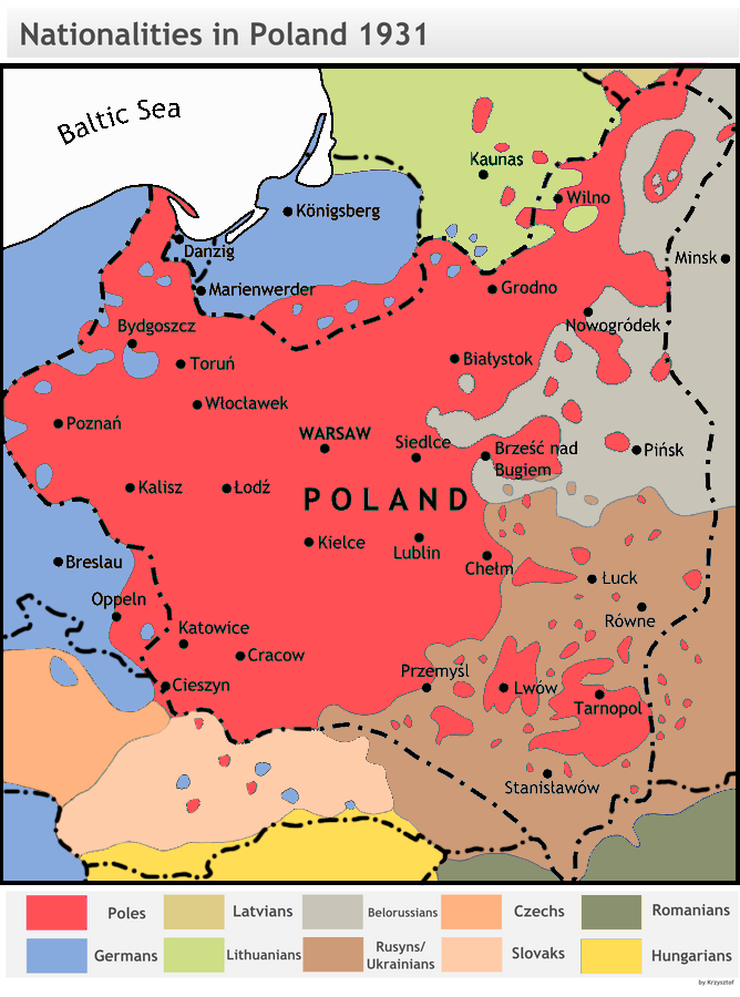
| Description | Dominating nationalities in Poland and around, 1931 (for the Polish census of 1931 see this map File:GUS languages1931 Poland.jpg). |
| Source |
1. Image:HistPol-narodowosci1931.png, 2. Eugenjusz Romer, POWSZECHNY ATLAS GEOGRAFICZNY, Książnica-Atlas, Lwów-Warszawa 1928 (mapa 48 ludność), 3. Henryk Zieliński Historia Polski 1914-1939, Wydawnictwo Ossolineum 1983, 4. ATLAS HISTORYCZNY POLSKI, PPWK Warszawa-Wrocław 1998 (mapa na str. 46 narodowości). |
| Author | Based on work by Henryk Zieliński, colored and translated in June 2007 by Krzysztoflew |
| Permission (Reusing this file) |
GFDL and cc-by-sa-2.5 - derivative from original work |
| Other versions |
Derivative works of this file: NacionalidadesEnPolonia1931.svg Image:HistPol-narodowosci1931.png (black and white original) |
Compare with the map of ca. 1910 and Image:Narody2RP.png
Krzysztoflew, the copyright holder of this work, hereby publishes it under the following licenses:

|
Permission is granted to copy, distribute and/or modify this document under the terms of the GNU Free Documentation License, Version 1.2 or any later version published by the Free Software Foundation; with no Invariant Sections, no Front-Cover Texts, and no Back-Cover Texts. A copy of the license is included in the section entitled GNU Free Documentation License. |
| This file is licensed under the Creative Commons Attribution-Share Alike 3.0 Unported license. | ||
| Attribution: Krzysztoflew | ||
| ||
| This licensing tag was added to this file as part of the GFDL licensing update. |
This file is licensed under the Creative Commons Attribution-Share Alike 2.5 Generic, 2.0 Generic and 1.0 Generic license.
Attribution: Krzysztoflew
- You are free:
- to share – to copy, distribute and transmit the work
- to remix – to adapt the work
- Under the following conditions:
- attribution – You must give appropriate credit, provide a link to the license, and indicate if changes were made. You may do so in any reasonable manner, but not in any way that suggests the licensor endorses you or your use.
- share alike – If you remix, transform, or build upon the material, you must distribute your contributions under the same or compatible license as the original.
You may select the license of your choice.
File history
Click on a date/time to view the file as it appeared at that time.
| Date/Time | Thumbnail | Dimensions | User | Comment | |
|---|---|---|---|---|---|
| current | 16:18, 17 February 2023 | | 668 × 900 (193 KB) | Moodylo333 (talk | contribs) | Removed colour blind, details according with the sources cited. |
| 15:04, 12 April 2011 |  | 668 × 900 (233 KB) | Fentener van Vlissingen (talk | contribs) | Reverted to version as of 14:28, 18 September 2009; it is not "my own map", I simply reverted to an earlier version. Your version does not reflect the source and is therefore wrong | |
| 11:45, 30 August 2010 |  | 668 × 900 (295 KB) | Poeticbent (talk | contribs) | Reverted to version as of 22:07, 12 January 2009 Please, do not reintroduce mistakes. Current map includes various levels of ethnic mixture. Your own map doesn't, which is wrong. | |
| 14:28, 18 September 2009 |  | 668 × 900 (233 KB) | Fentener van Vlissingen (talk | contribs) | Reverted to version as of 18:53, 10 July 2007; the additional colours do not make sense as they are not explained in the legend (why would Silesia be blue-pinkish?). Update was also not motivated. | |
| 22:07, 12 January 2009 |  | 668 × 900 (295 KB) | Poeticbent (talk | contribs) | {{Information |Description= |Source= |Date= |Author= |Permission= |other_versions= }} | |
| 18:53, 10 July 2007 |  | 668 × 900 (233 KB) | Piotrus (talk | contribs) | {{Information |Description=Dominating nationalities in Poland and around, 1931. |Source= This file is a translated and colored illustration from "Historia Polski 1914-1939" by en:Henryk Zieliński (a Polish historian) published by Wydawnictwo Ossolin |
You cannot overwrite this file.
File usage on Commons
The following 4 pages use this file:
File usage on other wikis
The following other wikis use this file:
- Usage on ar.wikipedia.org
- Usage on be.wikipedia.org
- Usage on cs.wikipedia.org
- Usage on da.wikipedia.org
- Usage on de.wikipedia.org
- Usage on en.wikipedia.org
- Talk:Territories of Poland annexed by the Soviet Union
- Talk:Curzon Line
- Talk:History of Szczecin
- User talk:Scooter20
- Soviet annexation of Eastern Galicia and Volhynia
- Oder–Neisse line
- Talk:Soviet invasion of Poland/Archive 2
- User:Falcaorib/Ukraine
- User:Falcaorib/Poland-Lithuania
- User:Falcaorib/Belarus
- Usage on eo.wikipedia.org
- Usage on et.wikipedia.org
- Usage on fa.wikipedia.org
- Usage on fi.wikipedia.org
- Usage on fr.wikipedia.org
- Usage on hi.wikipedia.org
- Usage on hy.wikipedia.org
- Usage on ka.wikipedia.org
- Usage on ko.wikipedia.org
- Usage on lv.wikipedia.org
- Usage on no.wikipedia.org
- Usage on pl.wikipedia.org
- Usage on ru.wikipedia.org
- Usage on sc.wikipedia.org
- Usage on uk.wikipedia.org
- Usage on www.wikidata.org
- Usage on zh.wikipedia.org