File:Naturraeumliche Grossregionen Deutschlands plus.png
Jump to navigation
Jump to search
Size of this preview: 472 × 599 pixels. Other resolutions: 189 × 240 pixels | 378 × 480 pixels | 605 × 768 pixels | 807 × 1,024 pixels | 1,827 × 2,318 pixels.
Original file (1,827 × 2,318 pixels, file size: 6.48 MB, MIME type: image/png)
Captions
Captions
Add a one-line explanation of what this file represents
Summary
[edit]| Description |
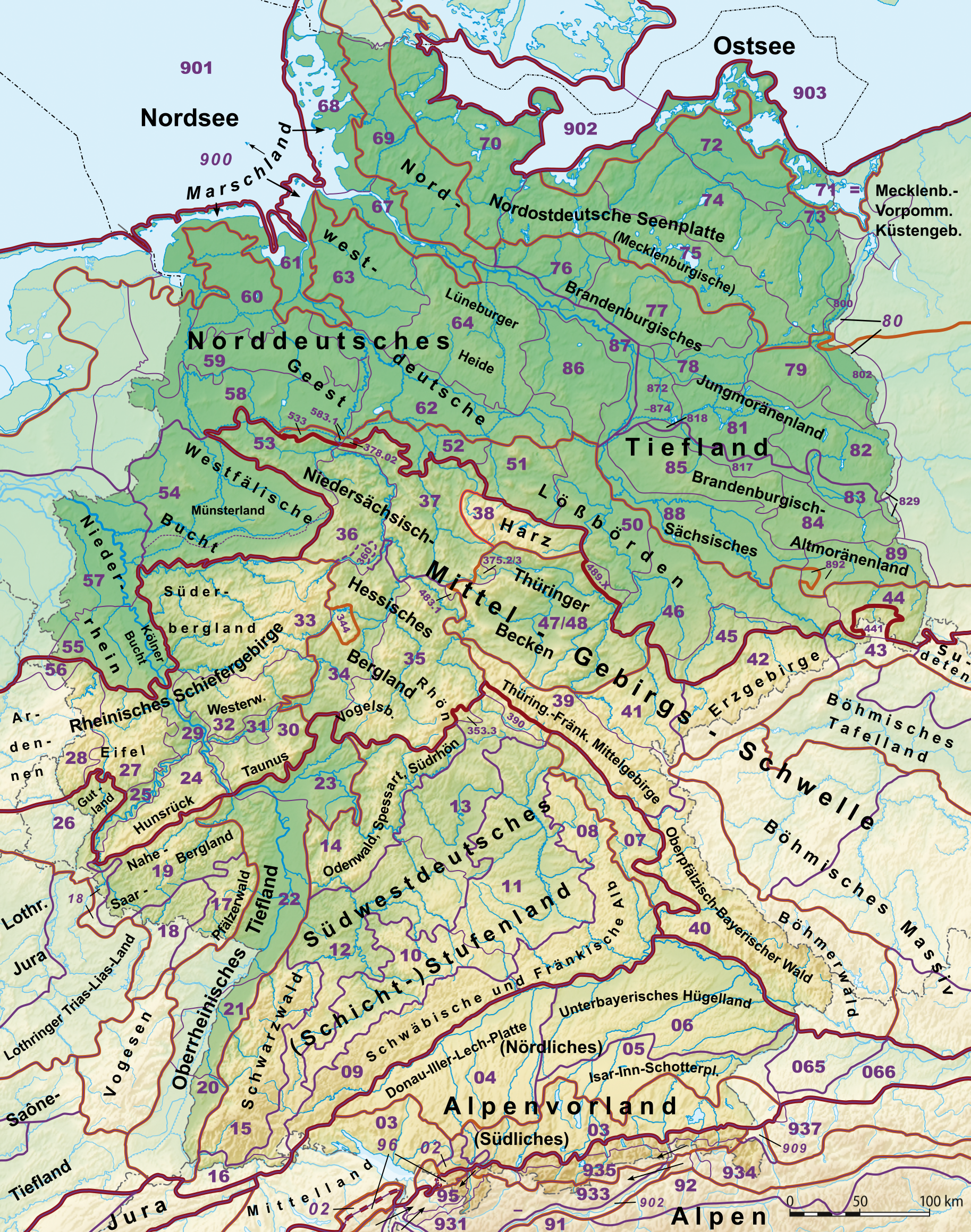
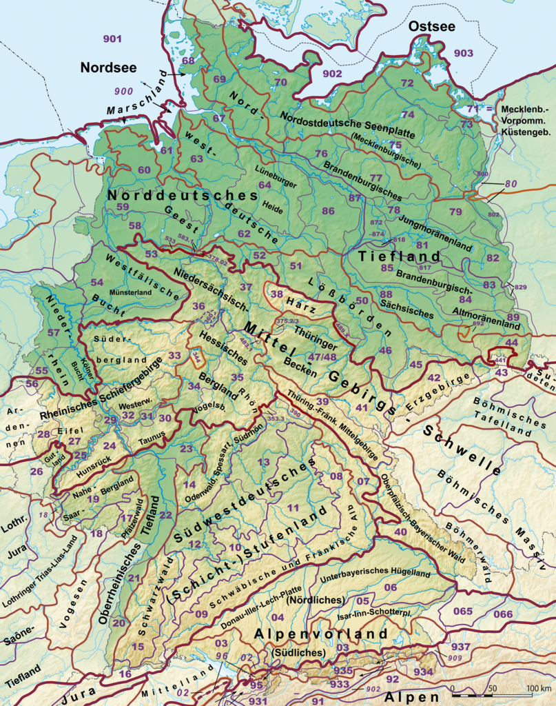
Deutsch: Karte der Naturräumlichen Großregionen Deutschlands
Legende
|
| Source | |
| Author |
|
| Other versions |
Derivative works of this file:
Ausschnittskarten: 1000 px breit
Andere Breiten
|


.png)

Licensing
[edit]
I, the copyright holder of this work, hereby publish it under the following licenses:

|
Permission is granted to copy, distribute and/or modify this document under the terms of the GNU Free Documentation License, Version 1.2 or any later version published by the Free Software Foundation; with no Invariant Sections, no Front-Cover Texts, and no Back-Cover Texts. A copy of the license is included in the section entitled GNU Free Documentation License. |
This file is licensed under the Creative Commons Attribution-Share Alike 3.0 Unported license.
- You are free:
- to share – to copy, distribute and transmit the work
- to remix – to adapt the work
- Under the following conditions:
- attribution – You must give appropriate credit, provide a link to the license, and indicate if changes were made. You may do so in any reasonable manner, but not in any way that suggests the licensor endorses you or your use.
- share alike – If you remix, transform, or build upon the material, you must distribute your contributions under the same or compatible license as the original.
You may select the license of your choice.
File history
Click on a date/time to view the file as it appeared at that time.
| Date/Time | Thumbnail | Dimensions | User | Comment | |
|---|---|---|---|---|---|
| current | 22:36, 23 December 2020 | | 1,827 × 2,318 (6.48 MB) | Elop (talk | contribs) | |
| 21:07, 23 December 2020 |  | 1,827 × 2,318 (6.48 MB) | Elop (talk | contribs) | ||
| 18:53, 25 December 2014 |  | 1,827 × 2,318 (6.53 MB) | Elop (talk | contribs) | Lößbörden korr. (533), insbesondere Grenzverlauf; Vorland des Thüringer Waldes (380) strittige Naturräume mit Nummern | |
| 13:42, 22 November 2014 |  | 1,827 × 2,318 (6.52 MB) | Elop (talk | contribs) | Korrekturen im Norden: Statt "Ems-Weser-Geest" und "Nordelbische Geest" zusammenfassend "Norddeutsche"; Lüneheide und Meckerplatte als sehr bekannte Landschaften beschriftet; dicke Linie zwischen Erst- und Zweitgenannter gedünnt, Außenlinie von 87 a... | |
| 13:46, 2 July 2012 |  | 1,827 × 2,318 (6.52 MB) | Elop (talk | contribs) | k | |
| 21:29, 1 July 2012 |  | 1,827 × 2,318 (6.52 MB) | Elop (talk | contribs) | k | |
| 15:08, 1 July 2012 |  | 1,827 × 2,318 (6.52 MB) | Elop (talk | contribs) | k | |
| 22:44, 30 June 2012 |  | 1,827 × 2,318 (6.49 MB) | Elop (talk | contribs) | Update; insbesondere Alpen komplett neu; alle Pfade neu nachgezeichnet und korrigiert, auch außerhalb Dlands; NNWs Karte damit vektoriell erneuert | |
| 14:31, 27 May 2012 |  | 1,827 × 2,318 (6.5 MB) | Elop (talk | contribs) | Update | |
| 00:25, 25 October 2011 |  | 1,827 × 2,318 (6.49 MB) | Elop (talk | contribs) | k |
You cannot overwrite this file.
File usage on Commons
The following 7 pages use this file:
- File:Deutschland Naturraeumliche Grossregionen.png
- File:Deutschland Naturräumliche Haupteinheiten alt.png
- File:Haupteinheitengruppen Suedwestdeutsches Stufenland.png
- File:Naturraeumliche Grossregionen Deutschlands, Erzgebirge.png
- File:Naturraeumliche Grossregionen Deutschlands, Schwarzwald.png
- File:Naturräumliche Großregionen Deutschlands plus.png (file redirect)
- Category:Natural regions of Germany
File usage on other wikis
The following other wikis use this file:
- Usage on cs.wikipedia.org
- Usage on de.wikipedia.org
- Mittelgebirge
- Norddeutsches Tiefland
- Liste der Landschaften in Bayern
- Mittelgebirgsschwelle
- Naturräume in Sachsen
- Naturräumliche Großregionen Deutschlands
- Naturraum
- Portal:Umwelt- und Naturschutz/Artikel des Monats
- Diskussion:Mitteldeutschland/Archiv/1
- Benutzer:Frze
- Benutzer Diskussion:Elop/Archiv 2011
- Wikipedia:WikiProjekt Geographie/Projekt Naturräumliche Gliederung Mitteleuropas
- Vorlage:Positionskarte Deutschland Naturraum
- Vorlage Diskussion:Positionskarte Deutschland Naturraum
- Benutzer:Elop/Galerie/Karten
- Nordbrandenburgisches Platten- und Hügelland
- Mittelbrandenburgische Platten und Niederungen
- Usage on en.wikipedia.org
- Usage on es.wikipedia.org
- Usage on fr.wikipedia.org
- Usage on no.wikipedia.org
- Usage on pl.wikipedia.org
- Usage on ru.wikipedia.org
- Usage on sl.wikipedia.org
- Usage on www.wikidata.org