File:Nemuro Subprefecture of Hokkaido.png
Jump to navigation
Jump to search
No higher resolution available.
Nemuro_Subprefecture_of_Hokkaido.png (300 × 152 pixels, file size: 15 KB, MIME type: image/png)
Captions
Captions
Add a one-line explanation of what this file represents
Summary
[edit]
| Description |
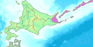
English: This map shows the jurisdiction of the Nemuro Subprefecture in Hokkaido with the claimed islands (Northern Territories): Habomai islands, Shikotan, Kunashiri and Etorofu.
日本語: 北海道・根室支庁の所管地域を示した図。 |
| Date | 21 October 2004 (original upload date) |
| Source |
|
| Author | Birdman at Japanese Wikipedia |
Licensing
[edit]
| This file is licensed under the Creative Commons Attribution-Share Alike 3.0 Unported license. Subject to disclaimers. | ||
| ||
| This licensing tag was added to this file as part of the GFDL licensing update. |

|
Permission is granted to copy, distribute and/or modify this document under the terms of the GNU Free Documentation License, Version 1.2 or any later version published by the Free Software Foundation; with no Invariant Sections, no Front-Cover Texts, and no Back-Cover Texts. A copy of the license is included in the section entitled GNU Free Documentation License. Subject to disclaimers. |
Original upload log
[edit]
The original description page was here. All following user names refer to ja.wikipedia.
- 2005-09-30 17:34 Birdman 300×152× (14946 bytes) 支庁界変更を反映
- 2005-07-15 15:00 Birdman 300×152× (14974 bytes) 北海道・[[根室支庁]]の所管地域を示した図。{{GFDL}}
- 2004-10-21 20:22 Birdman 300×132× (2087 bytes) 北海道根室支庁の所管区域図。[[:画像:Hokkaido bw.png]]を基に投稿者が作成。
| This file was moved from Japanese Wikipedia.
See below for original file information. | ||||||||||||||||||||||||||||||||||||
| ||||||||||||||||||||||||||||||||||||
|
| ||||||||||||||||||||||||||||||||||||
File history
Click on a date/time to view the file as it appeared at that time.
| Date/Time | Thumbnail | Dimensions | User | Comment | |
|---|---|---|---|---|---|
| current | 20:12, 20 September 2020 | | 300 × 152 (15 KB) | OgreBot (talk | contribs) | (BOT): Reverting to most recent version before archival |
| 20:12, 20 September 2020 |  | 300 × 152 (15 KB) | OgreBot (talk | contribs) | (BOT): Uploading old version of file from ja.wikipedia; originally uploaded on 2005-07-15 15:00:52 by Birdman | |
| 20:12, 20 September 2020 |  | 300 × 132 (2 KB) | OgreBot (talk | contribs) | (BOT): Uploading old version of file from ja.wikipedia; originally uploaded on 2004-10-21 20:22:49 by Birdman | |
| 16:17, 25 March 2006 |  | 300 × 152 (15 KB) | Maksim (talk | contribs) | La bildo estas kopiita de wikipedia:ja. La originala priskribo estas: 北海道・根室支庁の所管地域を示した図。 *[http://www2.demis.nl/mapserver/mapper.asp DEMIS World Map Server]の生成した画像データ(public domain)と、[[: |
You cannot overwrite this file.
File usage on Commons
The following 2 pages use this file:
File usage on other wikis
The following other wikis use this file:
- Usage on eo.wikipedia.org
- Usage on it.wikipedia.org
- Usage on ja.wikipedia.org