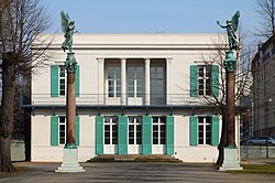
File:Neuer Pavillon Front.jpg
From Wikimedia Commons, the free media repository
Jump to navigation
Jump to search

Size of this preview: 800 × 530 pixels. Other resolutions: 320 × 212 pixels | 640 × 424 pixels | 1,024 × 679 pixels | 1,280 × 848 pixels | 2,560 × 1,697 pixels | 4,632 × 3,070 pixels.
Original file (4,632 × 3,070 pixels, file size: 4.21 MB, MIME type: image/jpeg)
File information
Structured data
Captions
Captions
Add a one-line explanation of what this file represents
Contents
Summary
Object
| Karl Friedrich Schinkel: Neuer Pavillon
|
|||||||||||||||||||||||||||
|---|---|---|---|---|---|---|---|---|---|---|---|---|---|---|---|---|---|---|---|---|---|---|---|---|---|---|---|
| Architect |
|
||||||||||||||||||||||||||
| Title |
Neuer Pavillon label QS:Lja,"新パビリオン"
label QS:Lde,"Neuer Pavillon"
label QS:Len,"Neuer Pavillon"
label QS:Lhe,"נוייר פביליון"
label QS:Lfr,"Nouveau pavillon" |
||||||||||||||||||||||||||
| Part of |
Charlottenburg Palace |
||||||||||||||||||||||||||
| Object type |
museum building |
||||||||||||||||||||||||||
| Description |
English: Front of the Neuer Pavillon. |
||||||||||||||||||||||||||
| Date |
between 1824 and 1825 date QS:P,+1824-00-00T00:00:00Z/8,P1319,+1824-00-00T00:00:00Z/9,P1326,+1825-00-00T00:00:00Z/9 |
||||||||||||||||||||||||||
| Collection |
institution QS:P195,Q154996 |
||||||||||||||||||||||||||
| Object location |
|
||||||||||||||||||||||||||
| Authority file | |||||||||||||||||||||||||||
Photograph
| Date | |
| Source | Own work |
| Author | Morn the Gorn |
| OpenStreetMap InfoField | Way 11544256 |
| Object location | 52° 31′ 16.7″ N, 13° 17′ 57″ E | View this and other nearby images on: OpenStreetMap |
|---|
| Camera location | 52° 31′ 16.68″ N, 13° 17′ 52.8″ E | View this and other nearby images on: OpenStreetMap |
|---|
Licensing
I, the copyright holder of this work, hereby publish it under the following licenses:
This file is licensed under the Creative Commons Attribution-Share Alike 3.0 Unported license.
- You are free:
- to share – to copy, distribute and transmit the work
- to remix – to adapt the work
- Under the following conditions:
- attribution – You must give appropriate credit, provide a link to the license, and indicate if changes were made. You may do so in any reasonable manner, but not in any way that suggests the licensor endorses you or your use.
- share alike – If you remix, transform, or build upon the material, you must distribute your contributions under the same or compatible license as the original.

|
Permission is granted to copy, distribute and/or modify this document under the terms of the GNU Free Documentation License, Version 1.2 or any later version published by the Free Software Foundation; with no Invariant Sections, no Front-Cover Texts, and no Back-Cover Texts. A copy of the license is included in the section entitled GNU Free Documentation License.http://www.gnu.org/copyleft/fdl.htmlGFDLGNU Free Documentation Licensetruetrue |
You may select the license of your choice.
File history
Click on a date/time to view the file as it appeared at that time.
| Date/Time | Thumbnail | Dimensions | User | Comment | |
|---|---|---|---|---|---|
| current | 23:41, 22 March 2010 |  | 4,632 × 3,070 (4.21 MB) | Morn (talk | contribs) | redone with Canon DPP |
| 20:36, 19 March 2010 |  | 4,720 × 3,119 (4.21 MB) | Morn (talk | contribs) | {{Information |Description={{en|1=Front of the Neuer Pavillon.}} |Source={{own}} |Author=Morn the Gorn |Date=2010-03-18 |Permission= |other_versions= }} Category:Neuer Pavillon |
You cannot overwrite this file.
File usage on Commons
The following 13 pages use this file:
- Commons:Files used on OpenStreetMap/104
- File:1024 Charlottenburg im Schloßpark- Schinkel-Pavillon-7193.jpg
- File:2020-04-24 Detail-Neuer-Pavillon-Sternenbalkon.jpg
- File:Berlin-Charlottenburg, Schloss, der Neue Pavillon.JPG
- File:Berlin annexe du Charlottenburg Schloss.jpg
- File:Caspar David Friedrich - Gartenterrasse (Schlossterrasse, Blick von der Terrasse des Schlosses Erdmannsdorf).jpg
- File:Charlottenburg Palace, Berlin (2015) - 20.JPG
- File:Neuer-Pavillon-Schlossgarten-Charlottenburg-Berlin-05-2017.jpg
- File:Neuer-Pavillon-Schlossgarten-Charlottenburg-Berlin-05-2017a.jpg
- File:Neuer Pavillon Front.jpg
- File:Schinkel1.jpg
- File:The Garden Terrace by Caspar David Friedrich.jpg
- Category:Neuer Pavillon
File usage on other wikis
The following other wikis use this file:
- Usage on de.wikipedia.org
- Usage on en.wikipedia.org
- Usage on ru.wikipedia.org
- Usage on www.wikidata.org
Metadata
This file contains additional information such as Exif metadata which may have been added by the digital camera, scanner, or software program used to create or digitize it. If the file has been modified from its original state, some details such as the timestamp may not fully reflect those of the original file. The timestamp is only as accurate as the clock in the camera, and it may be completely wrong.
| Camera manufacturer | Canon |
|---|---|
| Camera model | Canon EOS 50D |
| Exposure time | 1/320 sec (0.003125) |
| F-number | f/9 |
| ISO speed rating | 100 |
| Date and time of data generation | 14:49, 18 March 2010 |
| Lens focal length | 80 mm |
| Orientation | Normal |
| Horizontal resolution | 72 dpi |
| Vertical resolution | 72 dpi |
| Software used | QuickTime 7.6.4 |
| File change date and time | 00:36, 23 March 2010 |
| Y and C positioning | Centered |
| Exif version | 2.2 |
| Date and time of digitizing | 14:49, 18 March 2010 |
| APEX shutter speed | 8.375 |
| APEX aperture | 6.375 |
| APEX exposure bias | 0 |
| Flash | Flash did not fire, compulsory flash suppression |
| Color space | sRGB |


