File:Normandy campaign 1204.png
Jump to navigation
Jump to search
No higher resolution available.
Normandy_campaign_1204.png (522 × 327 pixels, file size: 235 KB, MIME type: image/png)
Captions
Captions
Add a one-line explanation of what this file represents

|
This military map image could be re-created using vector graphics as an SVG file. This has several advantages; see Commons:Media for cleanup for more information. If an SVG form of this image is available, please upload it and afterwards replace this template with
{{vector version available|new image name}}.
It is recommended to name the SVG file “Normandy campaign 1204.svg”—then the template Vector version available (or Vva) does not need the new image name parameter. |
| Description |
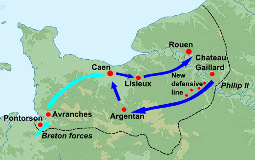
English: Blank topographic map of France in the official Lambert-93 projection, with details of Normandy campaign in 1205 overlaid, information from Warren "King John", p.98. Note: The background map is a raster image embedded in the SVG file. Français : Carte topographique vierge de la France suivant la projection officielle Lambert-93. Note : Le fond de carte est une image bitmap embarquée dans le fichier SVG. Lambert-93 projection ; RGF-93 datum Scales: *Topography: 1:2,490,000 (precision 623 m) *Bathymetry: 1:7,640,000 (precision 1,910 m) |
| Date | (UTC) |
| Source |
Own work using:
|
| Author |
|
| Other versions | Derivative works of this file: Great Revolt Normandy 1173.png |
| This is a retouched picture, which means that it has been digitally altered from its original version. Modifications: Trimmed, details of 1204 Normandy campaign added; details from Warren, "King John", p.98. The original can be viewed here: France map Lambert-93 topographic-blank.svg:
|
I, the copyright holder of this work, hereby publish it under the following licenses:
This file is licensed under the Creative Commons Attribution-Share Alike 3.0 Unported, 2.5 Generic, 2.0 Generic and 1.0 Generic license.
- You are free:
- to share – to copy, distribute and transmit the work
- to remix – to adapt the work
- Under the following conditions:
- attribution – You must give appropriate credit, provide a link to the license, and indicate if changes were made. You may do so in any reasonable manner, but not in any way that suggests the licensor endorses you or your use.
- share alike – If you remix, transform, or build upon the material, you must distribute your contributions under the same or compatible license as the original.

|
Permission is granted to copy, distribute and/or modify this document under the terms of the GNU Free Documentation License, Version 1.2 or any later version published by the Free Software Foundation; with no Invariant Sections, no Front-Cover Texts, and no Back-Cover Texts. A copy of the license is included in the section entitled GNU Free Documentation License. |
You may select the license of your choice.
Original upload log
[edit]
This image is a derivative work of the following images:
- File:France_map_Lambert-93_topographic-blank.svg licensed with Cc-by-sa-3.0,2.5,2.0,1.0, GFDL
- 2008-11-13T17:24:53Z Sting 2000x1898 (1639447 Bytes) + boundary for Channel Islands ; - canals
- 2008-10-01T04:59:44Z Sting 2000x1898 (1682809 Bytes) == Summary == {{Location|46|15|00|N|02|06|00|E|scale:10000000}} {{Information |Description={{en|Blank topographic map of [[:en:France|France]] in the official Lambert-93 projection.}} {{fr|Carte topographique vierge de la [[
Uploaded with derivativeFX
File history
Click on a date/time to view the file as it appeared at that time.
| Date/Time | Thumbnail | Dimensions | User | Comment | |
|---|---|---|---|---|---|
| current | 09:31, 3 January 2011 | | 522 × 327 (235 KB) | Hchc2009 (talk | contribs) | Arrows curved |
| 23:39, 1 January 2011 |  | 557 × 334 (255 KB) | Hchc2009 (talk | contribs) | Text made bigger | |
| 23:25, 1 January 2011 |  | 515 × 352 (249 KB) | Hchc2009 (talk | contribs) | {{Information |Description={{en|Blank topographic map of France in the official Lambert-93 projection.<br/>''Note:'' The background map is a raster image embedded in the SVG file.}} {{fr|Carte topographique vierge de la [[:fr:France|France] |
You cannot overwrite this file.
File usage on Commons
The following page uses this file:
File usage on other wikis
The following other wikis use this file:
- Usage on ar.wikipedia.org
- Usage on de.wikipedia.org
- Usage on en.wikipedia.org
- Usage on es.wikipedia.org
- Usage on fa.wikipedia.org
- Usage on fr.wikipedia.org
- Usage on gl.wikipedia.org
- Usage on hu.wikipedia.org
- Usage on hy.wikipedia.org
- Usage on id.wikipedia.org
- Usage on ja.wikipedia.org
- Usage on nl.wikipedia.org
- Usage on ru.wikipedia.org
- Usage on www.wikidata.org
- Usage on zh-min-nan.wikipedia.org
- Usage on zh.wikipedia.org