File:Nouvelle-France1750.jpg
Jump to navigation
Jump to search
Size of this preview: 617 × 599 pixels. Other resolutions: 247 × 240 pixels | 494 × 480 pixels | 790 × 768 pixels | 1,054 × 1,024 pixels | 1,795 × 1,744 pixels.
Original file (1,795 × 1,744 pixels, file size: 234 KB, MIME type: image/jpeg)
Captions
Captions
Add a one-line explanation of what this file represents
Summary
[edit]
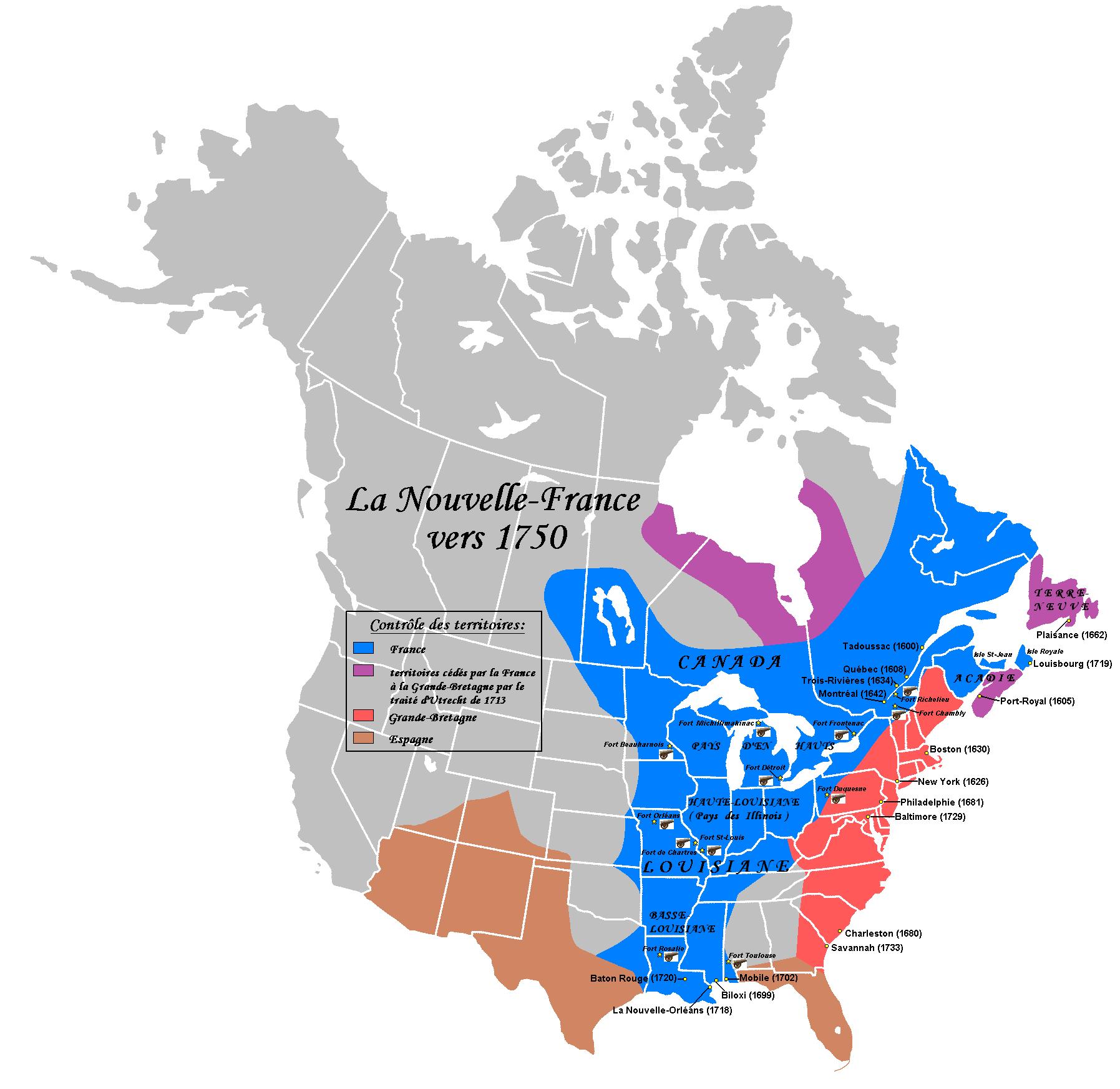
| Description | Carte de la Nouvelle-France vers 1750 |
| Date | |
| Source |
1)Les Villes françaises du Nouveau Monde : des premiers fondateurs aux ingénieurs du roi, XVIe-XVIIIe siècles / sous la direction de Laurent Vidal et Emilie d'Orgeix /Éditeur: Paris: Somogy 1999. 2) Canada-Québec 1534-2000/ Jacques Lacoursière, Jean Provencher et Denis Vaugeois/Éditeur: Sillery (Québec): Septentrion 2000. |
| Author | JF Lepage |

|
File:Nouvelle-France map-fr.svg is a vector version of this file. It should be used in place of this JPG file.
File:Nouvelle-France1750.jpg → File:Nouvelle-France map-fr.svg
For more information, see Help:SVG. |
 |
Licensing
[edit]
I, the copyright holder of this work, hereby publish it under the following licenses:

|
Permission is granted to copy, distribute and/or modify this document under the terms of the GNU Free Documentation License, Version 1.2 or any later version published by the Free Software Foundation; with no Invariant Sections, no Front-Cover Texts, and no Back-Cover Texts. A copy of the license is included in the section entitled GNU Free Documentation License. |
| This file is licensed under the Creative Commons Attribution-Share Alike 3.0 Unported license. | ||
| ||
| This licensing tag was added to this file as part of the GFDL licensing update. |
This file is licensed under the Creative Commons Attribution-Share Alike 2.5 Generic, 2.0 Generic and 1.0 Generic license.
- You are free:
- to share – to copy, distribute and transmit the work
- to remix – to adapt the work
- Under the following conditions:
- attribution – You must give appropriate credit, provide a link to the license, and indicate if changes were made. You may do so in any reasonable manner, but not in any way that suggests the licensor endorses you or your use.
- share alike – If you remix, transform, or build upon the material, you must distribute your contributions under the same or compatible license as the original.
You may select the license of your choice.
File history
Click on a date/time to view the file as it appeared at that time.
| Date/Time | Thumbnail | Dimensions | User | Comment | |
|---|---|---|---|---|---|
| current | 15:54, 23 June 2007 | | 1,795 × 1,744 (234 KB) | JF Lepage (talk | contribs) | {{Information |Description=Carte de la Nouvelle-France vers 1750 |Source=1)Les Villes françaises du Nouveau Monde : des premiers fondateurs aux ingénieurs du roi, XVIe-XVIIIe siècles / sous la direction de Laurent Vidal et Emilie d'Orgeix /Éditeur: Pa |
| 16:46, 3 June 2007 |  | 1,795 × 1,744 (226 KB) | JF Lepage (talk | contribs) | {{Information |Description=Carte de la Nouvelle-France vers 1750 |Source= 1)Les Villes françaises du Nouveau Monde : des premiers fondateurs aux ingénieurs du roi, XVIe-XVIIIe siècles / sous la direction de Laurent Vidal et Emilie d'Orgeix /Éditeur: P |
You cannot overwrite this file.
File usage on Commons
There are no pages that use this file.
File usage on other wikis
The following other wikis use this file:
- Usage on fr.wikipedia.org