File:Nouvelle-France map-zh-hans.svg
Jump to navigation
Jump to search

Size of this PNG preview of this SVG file: 800 × 570 pixels. Other resolutions: 320 × 228 pixels | 640 × 456 pixels | 1,024 × 730 pixels | 1,280 × 912 pixels | 2,560 × 1,824 pixels | 1,530 × 1,090 pixels.
Original file (SVG file, nominally 1,530 × 1,090 pixels, file size: 231 KB)
Captions
Captions
Add a one-line explanation of what this file represents
Summary
[edit]| Description |
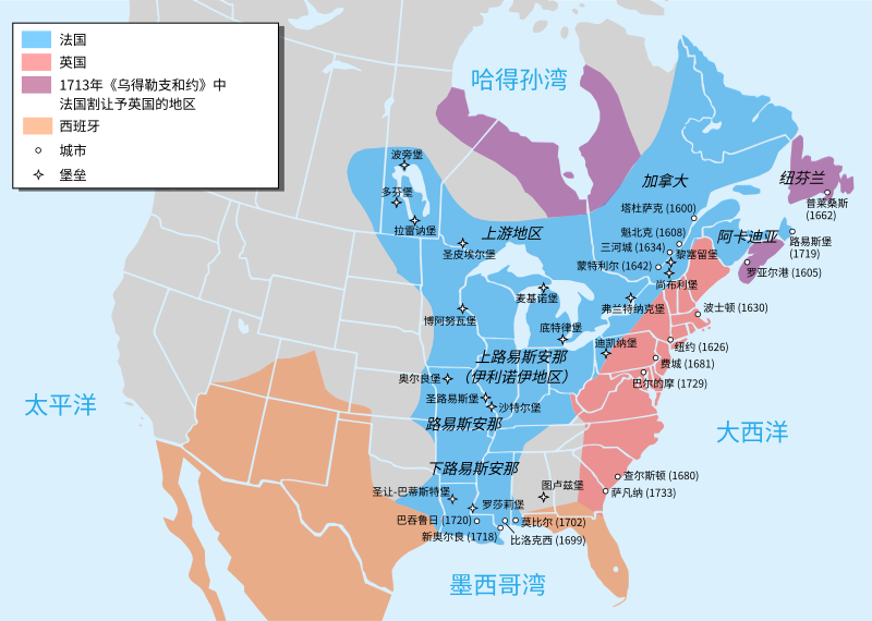
Català: Mapa de la Nova França sobre 1754-1755 English: Map of New France about 1750 using modern political boundaries Español: Mapa de la Nueva Francia cerca de 1750. Français : Carte de la Nouvelle-France vers 1754-1755 Norsk nynorsk: Kart over Ny Frankrike (ca 1754-1755) Русский: Карта Французских колоний в Америке 1750 中文(中国大陆): 1750年左右的新法兰西地图,附现代边界。 العربية : خريطة فرنسا الجديدة حوالي عام 1750 باستخدام الحدود السياسية الحديثة |
||
| Date | |||
| Source | File:Nouvelle-France map-en.svg | ||
| Author | Pinpin, translated by Buernia | ||
| Other versions |
[]
|


Licensing
[edit]
I, the copyright holder of this work, hereby publish it under the following licenses:

|
Permission is granted to copy, distribute and/or modify this document under the terms of the GNU Free Documentation License, Version 1.2 or any later version published by the Free Software Foundation; with no Invariant Sections, no Front-Cover Texts, and no Back-Cover Texts. A copy of the license is included in the section entitled GNU Free Documentation License. |
This file is licensed under the Creative Commons Attribution-Share Alike 3.0 Unported, 2.5 Generic, 2.0 Generic and 1.0 Generic license.
- You are free:
- to share – to copy, distribute and transmit the work
- to remix – to adapt the work
- Under the following conditions:
- attribution – You must give appropriate credit, provide a link to the license, and indicate if changes were made. You may do so in any reasonable manner, but not in any way that suggests the licensor endorses you or your use.
- share alike – If you remix, transform, or build upon the material, you must distribute your contributions under the same or compatible license as the original.
You may select the license of your choice.
File history
Click on a date/time to view the file as it appeared at that time.
| Date/Time | Thumbnail | Dimensions | User | Comment | |
|---|---|---|---|---|---|
| current | 13:29, 17 May 2023 | | 1,530 × 1,090 (231 KB) | Buernia (talk | contribs) | Fix font and translation. |
| 18:24, 16 December 2022 |  | 1,530 × 1,090 (231 KB) | Tcr25 (talk | contribs) | Fort Rosaile in wrong location; add Fort St-Jean-Baptiste | |
| 13:48, 9 May 2021 |  | 1,530 × 1,090 (237 KB) | Buernia (talk | contribs) | Uploaded a work by Pinpin, translated by Buernia from File:Nouvelle-France map-en.svg with UploadWizard |
You cannot overwrite this file.
File usage on Commons
The following 14 pages use this file:
- User:Buernia
- User:Magog the Ogre/Multilingual legend/2021 May 1-10
- User:Magog the Ogre/Multilingual legend/2022 December 11-20
- User:Magog the Ogre/Multilingual legend/2023 May 11-20
- File:Neufrankreich.svg
- File:Nouvelle-France map-ar.svg
- File:Nouvelle-France map-ca.svg
- File:Nouvelle-France map-en.svg
- File:Nouvelle-France map-es.svg
- File:Nouvelle-France map-fr.svg
- File:Nouvelle-France map-he.svg
- File:Nouvelle-France map-ru.svg
- File:Nouvelle-France map-zh-hans.svg
- Template:Other versions/Nouvelle-France map