File:Nova Scotia topographic map.png
Jump to navigation
Jump to search

Size of this preview: 734 × 599 pixels. Other resolutions: 294 × 240 pixels | 588 × 480 pixels | 940 × 768 pixels | 1,254 × 1,024 pixels | 1,342 × 1,096 pixels.
Original file (1,342 × 1,096 pixels, file size: 1.21 MB, MIME type: image/png)
Captions
Captions
Add a one-line explanation of what this file represents
Summary
[edit]| Description |
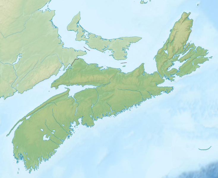
English: Topographic location map of Nova Scotia, Canada
Equirectangular projection, N/S stretching 145 %. Geographic limits of the map:
|
| Date | |
| Source | File:Carte topographique des Provinces Maritimes du Canada.svg |
| Author | Sémhur, GrandEscogriffe |
| Other versions |
|


Licensing
[edit]
This file is licensed under the Creative Commons Attribution-Share Alike 4.0 International license.
- You are free:
- to share – to copy, distribute and transmit the work
- to remix – to adapt the work
- Under the following conditions:
- attribution – You must give appropriate credit, provide a link to the license, and indicate if changes were made. You may do so in any reasonable manner, but not in any way that suggests the licensor endorses you or your use.
- share alike – If you remix, transform, or build upon the material, you must distribute your contributions under the same or compatible license as the original.
File history
Click on a date/time to view the file as it appeared at that time.
| Date/Time | Thumbnail | Dimensions | User | Comment | |
|---|---|---|---|---|---|
| current | 19:38, 22 March 2022 | | 1,342 × 1,096 (1.21 MB) | GrandEscogriffe (talk | contribs) | Uploaded a work by Sémhur GrandEscogriffe from File:Carte topographique des Provinces Maritimes du Canada.svg with UploadWizard |
You cannot overwrite this file.
File usage on Commons
The following 2 pages use this file:
File usage on other wikis
The following other wikis use this file:
- Usage on ban.wikipedia.org
- Usage on da.wikipedia.org
- Usage on en.wikipedia.org
- Bay of Fundy
- Cape Breton Highlands National Park
- New Glasgow, Nova Scotia
- Kejimkujik National Park
- Bras d'Or Lake
- Scotiabank Centre
- Minas Basin
- Cobequid Bay
- Lake Ainslie
- Mersey River (Nova Scotia)
- Centre 200
- Indian Harbour Lake, Nova Scotia
- Cape Breton Highlands
- Lake Banook
- Lake Micmac
- Sullivan's Pond
- Springfield Lake
- Mira River (Nova Scotia)
- Shubenacadie Grand Lake
- Waterford Lake
- Kejimikujik Lake
- Catcha Lake
- Medway River (Nova Scotia)
- Shelburne River
- Porters Lake, Nova Scotia
- Ingonish
- Lake Charlotte, Nova Scotia
- LaHave River
- Cape Dauphin
- White Hill (Nova Scotia)
- Lake Rossignol
- Module:Location map/data/Canada Nova Scotia/doc
- Chocolate Lake
- Sackville River
- St. Mary's River (Nova Scotia)
- Petite Rivière (Lunenburg County)
- Gaspereau Lake
- Lake Charles (Nova Scotia)
- Morris Lake (Nova Scotia)
- Russell Lake (Nova Scotia)
- Sgurra Bhreac (Nova Scotia)
- East Bay Hills (Nova Scotia)
- Queensland, Nova Scotia
- Lake Major, Nova Scotia
- Belle Lake (Nova Scotia)
- Blacketts Lake
- Ferguson Lake (Nova Scotia)
View more global usage of this file.