File:Ordnance Survey Drawings - Hythe, Kent (OSD 105).jpg
Jump to navigation
Jump to search
Size of this preview: 800 × 458 pixels. Other resolutions: 320 × 183 pixels | 640 × 366 pixels | 1,024 × 586 pixels | 1,280 × 732 pixels | 2,560 × 1,465 pixels | 4,000 × 2,289 pixels.
Original file (4,000 × 2,289 pixels, file size: 3.19 MB, MIME type: image/jpeg)
Captions
Captions
Add a one-line explanation of what this file represents
| Hythe (Kent) (OSD 105)
|
|||||
|---|---|---|---|---|---|
| Title |
Ordnance Survey Drawings: Hythe, Kent (OSD 105) |
.jpg) | |||
| Object type |
manuscript map |
||||
| Description |
 Centre of map shown on a map of England
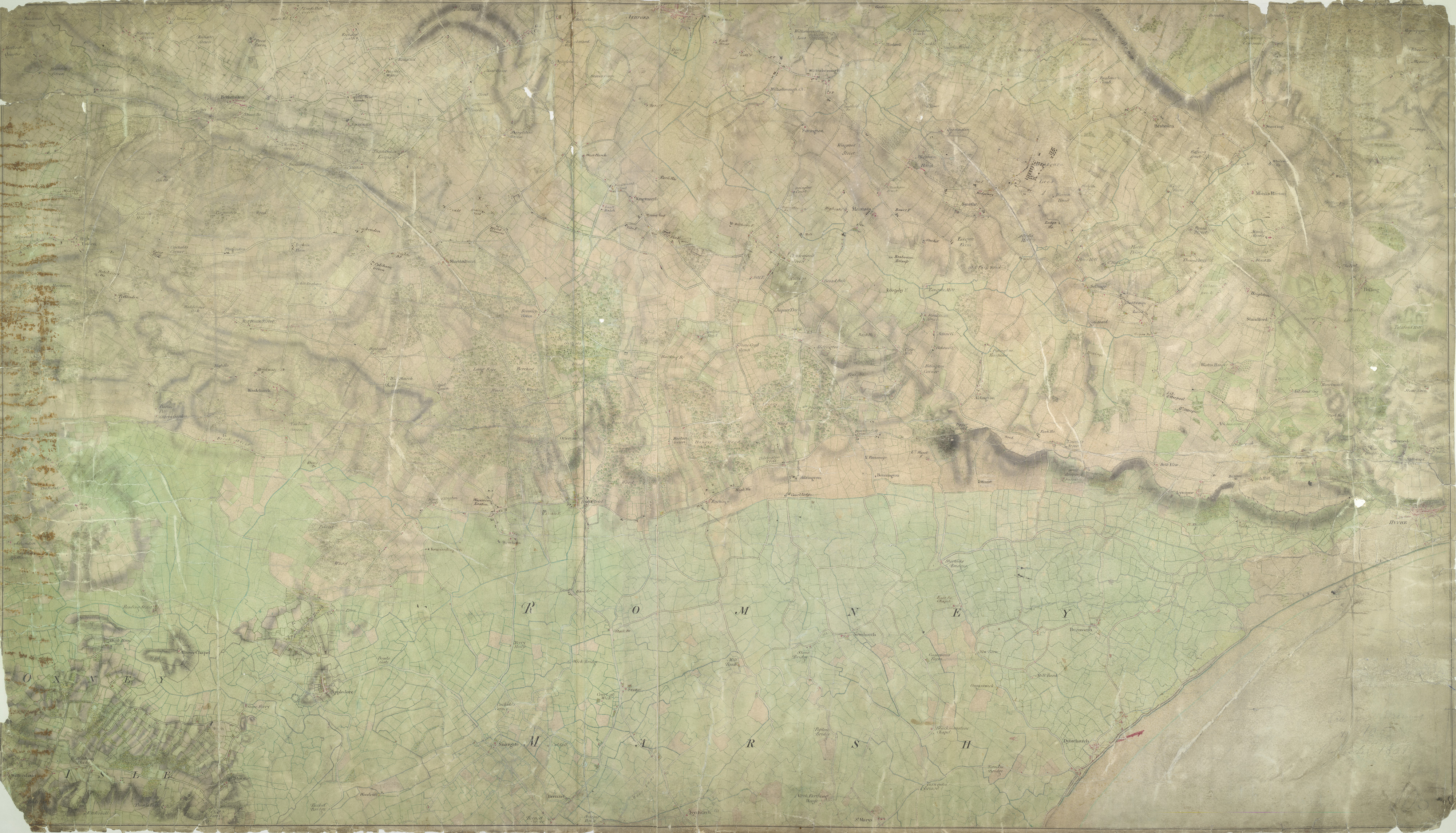
English: Drawing of the area in Kent to the west of Hythe and south of Ashford. The drawing is quite worn, making it hard to read. The Hythe coastline is indicated by a blue line. Romney Marsh is shown as a patchwork of green fields. The layout of an orchard at Westernhanger is represented by tiny drawings of individual trees. Detail such as this reveals the meticulousness of the Ordnance Survey.Near Ruckinge, a dot and pencil line are annotated "Military Canal". The Royal Military Canal was built in 1806, stretching for 28 miles from Hythe to Cliff End. It was built as a third line of defence against Napoleon, in combination with the Royal Navy patrol of the English Channel and the line of 74 Martello Towers along the south coast. The pencil line on this drawing, leading from Ruckinge across Romney Marsh to the coast, does not correspond to the actual position of the finished canal. The project had to wait five years after the drawing was produced before the government granted final approval..
This image has been georeferenced.
|
||||
| Language |
English |
||||
| Date | 1797 | ||||
| Medium | Pen and ink on paper | ||||
| Dimensions | height: 320 mm (12.59 in); width: 540 mm (21.25 in) | ||||
| Collection | |||||
| Accession number |
Maps OSD 105 |
||||
| Credit line | British Library | ||||
| Notes |
Scale 3 inches : 1 mile (1:21120). Please note that the British Library provides these digital files "as-is"; materials will not be rephotographed under this programme. If resupply of files is required, the requestor will be required to purchase them at the standard rate. |
||||
| References |
http://www.bl.uk/onlinegallery/onlineex/ordsurvdraw/h/002osd000000017u00364000.html (English) |
||||
| Source/Photographer |
|
||||
| Permission (Reusing this file) |
|
||||


_(St_Edwards_Crown).svg)
.jpg¶ms=51.080759_N_0.894045_E_)
.jpg¶ms=51.001603_N_0.689071_E_)
.jpg¶ms=51.159915_N_1.099019_E_)
.jpg¶ms=51.144016_N_0.689071_E_)
.jpg¶ms=51.001603_N_0.703487_E_)
.jpg¶ms=51.017503_N_1.099019_E_)
.jpg¶ms=51.159915_N_1.084603_E_)
File history
Click on a date/time to view the file as it appeared at that time.
| Date/Time | Thumbnail | Dimensions | User | Comment | |
|---|---|---|---|---|---|
| current | 22:15, 25 September 2013 | | 4,000 × 2,289 (3.19 MB) | LibraryBot (talk | contribs) | {{subst:User:Andrew Gray/OSD|ID= 002OSD000000017U00364000 |OSD_NUM= OSD 105 |MEDIUM= Pen and ink on paper |TITLE= Hythe, Kent |CREATOR= |YEAR= 1797 |DESCRIPTION= Drawing of the area in Kent to the west of Hythe and south of Ashford. The drawing is qui... |
You cannot overwrite this file.
File usage on Commons
The following page uses this file:
File usage on other wikis
The following other wikis use this file:
- Usage on www.wikidata.org
.jpg&oldid=912391483)