File:Ordnance Survey Drawings - Pershore, Worcestershire (OSD 217).jpg
Jump to navigation
Jump to search
Size of this preview: 757 × 600 pixels. Other resolutions: 303 × 240 pixels | 606 × 480 pixels | 970 × 768 pixels | 1,280 × 1,014 pixels | 2,560 × 2,028 pixels | 4,000 × 3,168 pixels.
Original file (4,000 × 3,168 pixels, file size: 3.31 MB, MIME type: image/jpeg)
Captions
Captions
Add a one-line explanation of what this file represents
| Pershore (OSD 217)
|
|||||
|---|---|---|---|---|---|
| Artist |
Dawson, Robert - Draughtsman |
.jpg) | |||
| Title |
Ordnance Survey Drawings: Pershore, Worcestershire (OSD 217) |
||||
| Object type |
manuscript map |
||||
| Description |
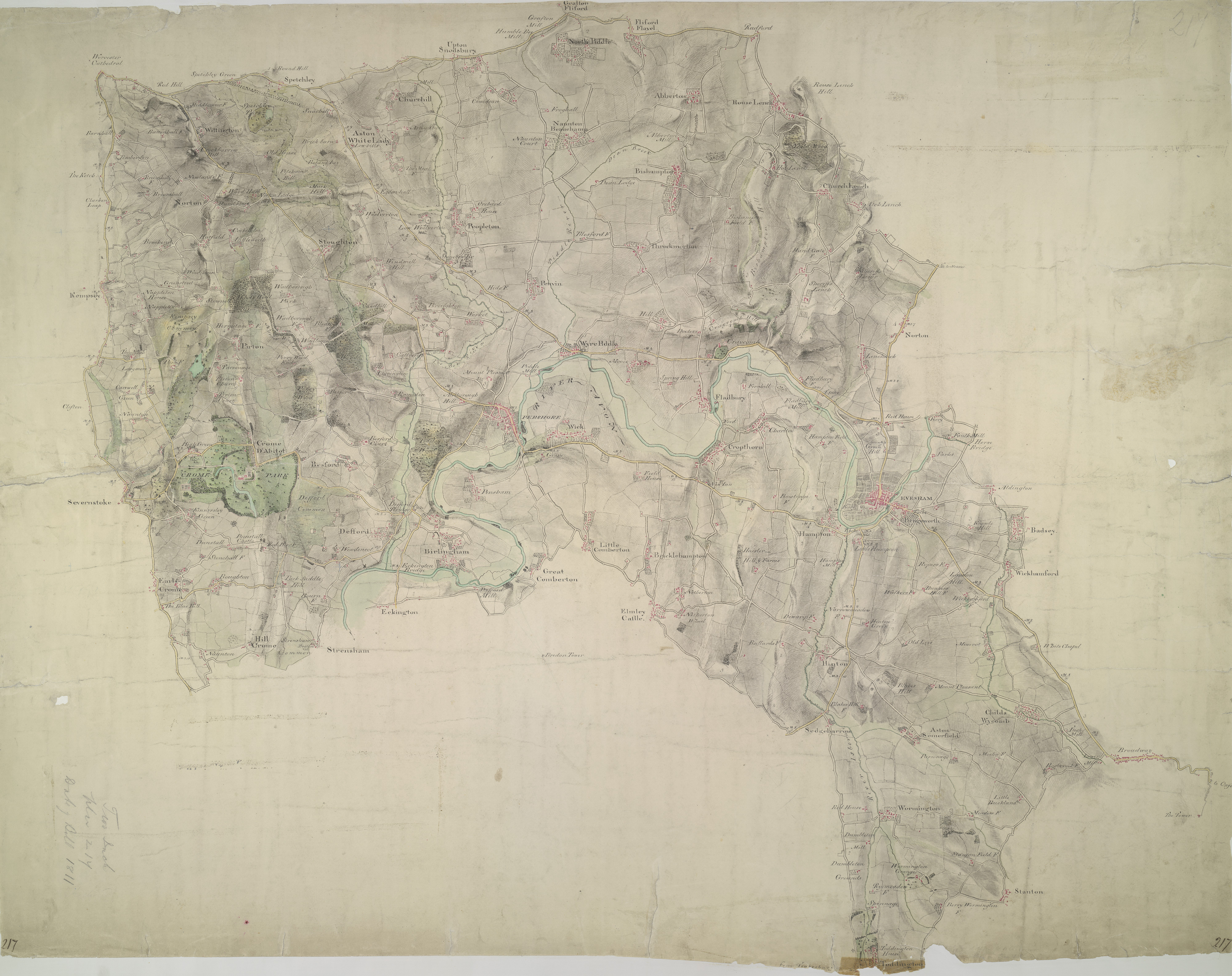
 Centre of map shown on a map of England
English: This plan, covering parts of Worcestershire and Gloucestershire, shows the River Avon Valley near the centre of the sheet. The valley is characterised by meadows and wetlands. Moorings along the river course are indicated between Pershore and Evesham..
This image has been georeferenced.
|
||||
| Language |
English |
||||
| Date | 1811 | ||||
| Medium | Pen and ink on paper | ||||
| Dimensions | height: 310 mm (12.20 in); width: 390 mm (15.35 in) | ||||
| Collection | |||||
| Accession number |
Maps OSD 217 |
||||
| Credit line | British Library | ||||
| Notes |
Scale 2 inches : 1 mile (1:31680). Please note that the British Library provides these digital files "as-is"; materials will not be rephotographed under this programme. If resupply of files is required, the requestor will be required to purchase them at the standard rate. |
||||
| References |
http://www.bl.uk/onlinegallery/onlineex/ordsurvdraw/p/002osd000000011u00176000.html (English) |
||||
| Source/Photographer |
|
||||
| Permission (Reusing this file) |
|
||||


_(St_Edwards_Crown).svg)
.jpg¶ms=52.096049_N_-2.038353_E_)
.jpg¶ms=51.990529_N_-2.254489_E_)
.jpg¶ms=52.201568_N_-1.822217_E_)
.jpg¶ms=52.201568_N_-2.252301_E_)
.jpg¶ms=51.993232_N_-2.254489_E_)
.jpg¶ms=51.990529_N_-1.824405_E_)
.jpg¶ms=52.198865_N_-1.822217_E_)
File history
Click on a date/time to view the file as it appeared at that time.
| Date/Time | Thumbnail | Dimensions | User | Comment | |
|---|---|---|---|---|---|
| current | 09:42, 26 September 2013 | | 4,000 × 3,168 (3.31 MB) | LibraryBot (talk | contribs) | {{subst:User:Andrew Gray/OSD|ID= 002OSD000000011U00176000 |OSD_NUM= OSD 217 |MEDIUM= Pen and ink on paper |TITLE= Pershore, Worcestershire |CREATOR= Dawson, Robert - Draughtsman |YEAR= 1811 |DESCRIPTION= This plan, covering parts of Worcestershire and ... |
You cannot overwrite this file.
File usage on Commons
The following page uses this file:
File usage on other wikis
The following other wikis use this file:
- Usage on www.wikidata.org
.jpg&oldid=924738863)