File:Ordnance Survey Drawings - Royal Tunbridge Wells (OSD 101).jpg
Jump to navigation
Jump to search
Size of this preview: 800 × 409 pixels. Other resolutions: 320 × 163 pixels | 640 × 327 pixels | 1,024 × 523 pixels | 1,280 × 654 pixels | 3,292 × 1,681 pixels.
Original file (3,292 × 1,681 pixels, file size: 2.79 MB, MIME type: image/jpeg)
Captions
Captions
Add a one-line explanation of what this file represents
| Tunbridge Wells (Kent) (OSD 101)
|
|||||
|---|---|---|---|---|---|
| Title |
Ordnance Survey Drawings: Royal Tunbridge Wells (OSD 101) |
.jpg) | |||
| Object type |
manuscript map |
||||
| Description |
 Centre of map shown on a map of England
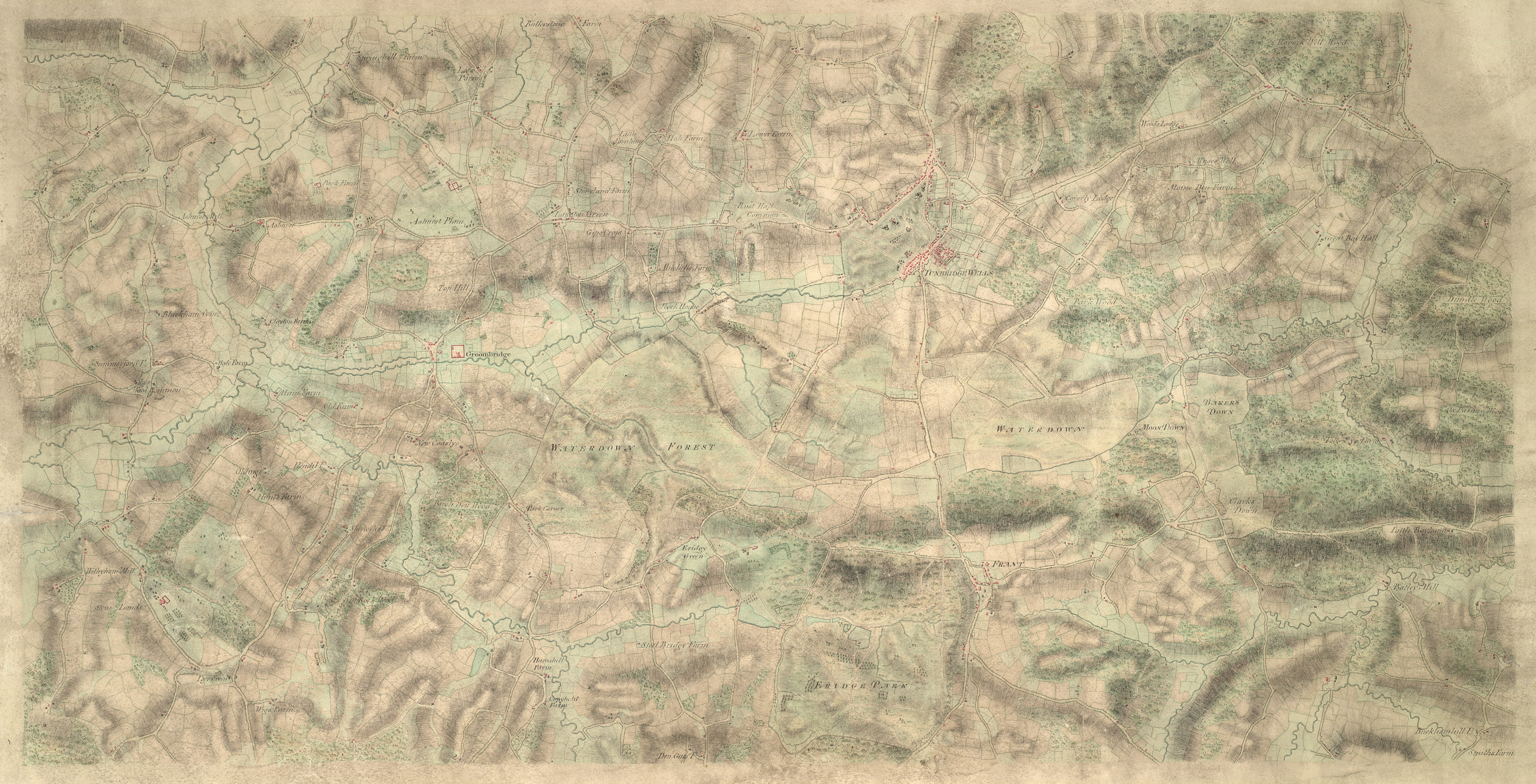
English: This drawing shows the area around Tunbridge Wells in Kent. The town itself is indicated by red blocks, with the surrounding forests and downs depicted by various green washes. Brushwork interlinging and shading ('hachuring') records relative relief. It is in this area in particular that the Ordnance Survey drawings surpass earlier county maps. The draughtsman has represented individual trees forming avenues and blocks, notably in Eridge Park..
This image has been georeferenced.
|
||||
| Language |
English |
||||
| Date | 1797 | ||||
| Medium | Pen and ink on paper | ||||
| Dimensions | 400 × 260 mm (15.74 × 10.23 in) | ||||
| Collection | |||||
| Accession number |
Maps OSD 101 |
||||
| Credit line | British Library | ||||
| Notes |
Scale 3 inches : 1 mile (1:21120). Please note that the British Library provides these digital files "as-is"; materials will not be rephotographed under this programme. If resupply of files is required, the requestor will be required to purchase them at the standard rate. |
||||
| References |
http://www.bl.uk/onlinegallery/onlineex/ordsurvdraw/t/002osd000000016u00357000.html (English) |
||||
| Source/Photographer |
|
||||
| Permission (Reusing this file) |
|
||||


_(St_Edwards_Crown).svg)
.jpg¶ms=51.116122_N_0.240228_E_)
.jpg¶ms=51.061711_N_0.098011_E_)
.jpg¶ms=51.170533_N_0.382444_E_)
.jpg¶ms=51.170143_N_0.098011_E_)
.jpg¶ms=51.061711_N_0.100327_E_)
.jpg¶ms=51.062101_N_0.382444_E_)
.jpg¶ms=51.170533_N_0.380128_E_)
File history
Click on a date/time to view the file as it appeared at that time.
| Date/Time | Thumbnail | Dimensions | User | Comment | |
|---|---|---|---|---|---|
| current | 18:43, 18 August 2024 | | 3,292 × 1,681 (2.79 MB) | Enyavar (talk | contribs) | Cropped 18 % horizontally, 31 % vertically, 43 % areawise, rotated 0.5° using CropTool with precise mode. |
| 22:29, 25 September 2013 |  | 4,000 × 2,423 (4.12 MB) | LibraryBot (talk | contribs) | {{subst:User:Andrew Gray/OSD|ID= 002OSD000000016U00357000 |OSD_NUM= OSD 101 |MEDIUM= Pen and ink on paper |TITLE= Royal Tunbridge Wells |CREATOR= |YEAR= 1797 |DESCRIPTION= This drawing shows the area around Tunbridge Wells in Kent. The town itself is ... |
You cannot overwrite this file.
File usage on Commons
The following page uses this file:
File usage on other wikis
The following other wikis use this file:
- Usage on www.wikidata.org
.jpg&oldid=912391500)