File:Ordnance Survey Drawings - Tardebigge, Worcestershire (OSD 218).jpg
Jump to navigation
Jump to search
Size of this preview: 655 × 600 pixels. Other resolutions: 262 × 240 pixels | 524 × 480 pixels | 839 × 768 pixels | 1,118 × 1,024 pixels | 2,236 × 2,048 pixels | 4,000 × 3,663 pixels.
Original file (4,000 × 3,663 pixels, file size: 5.01 MB, MIME type: image/jpeg)
Captions
Captions
Add a one-line explanation of what this file represents
| Tardebigge (OSD 218)
|
|||||
|---|---|---|---|---|---|
| Artist |
Dawson, Robert - Draughtsman |
.jpg) | |||
| Title |
Ordnance Survey Drawings: Tardebigge, Worcestershire (OSD 218) |
||||
| Object type |
manuscript map |
||||
| Description |
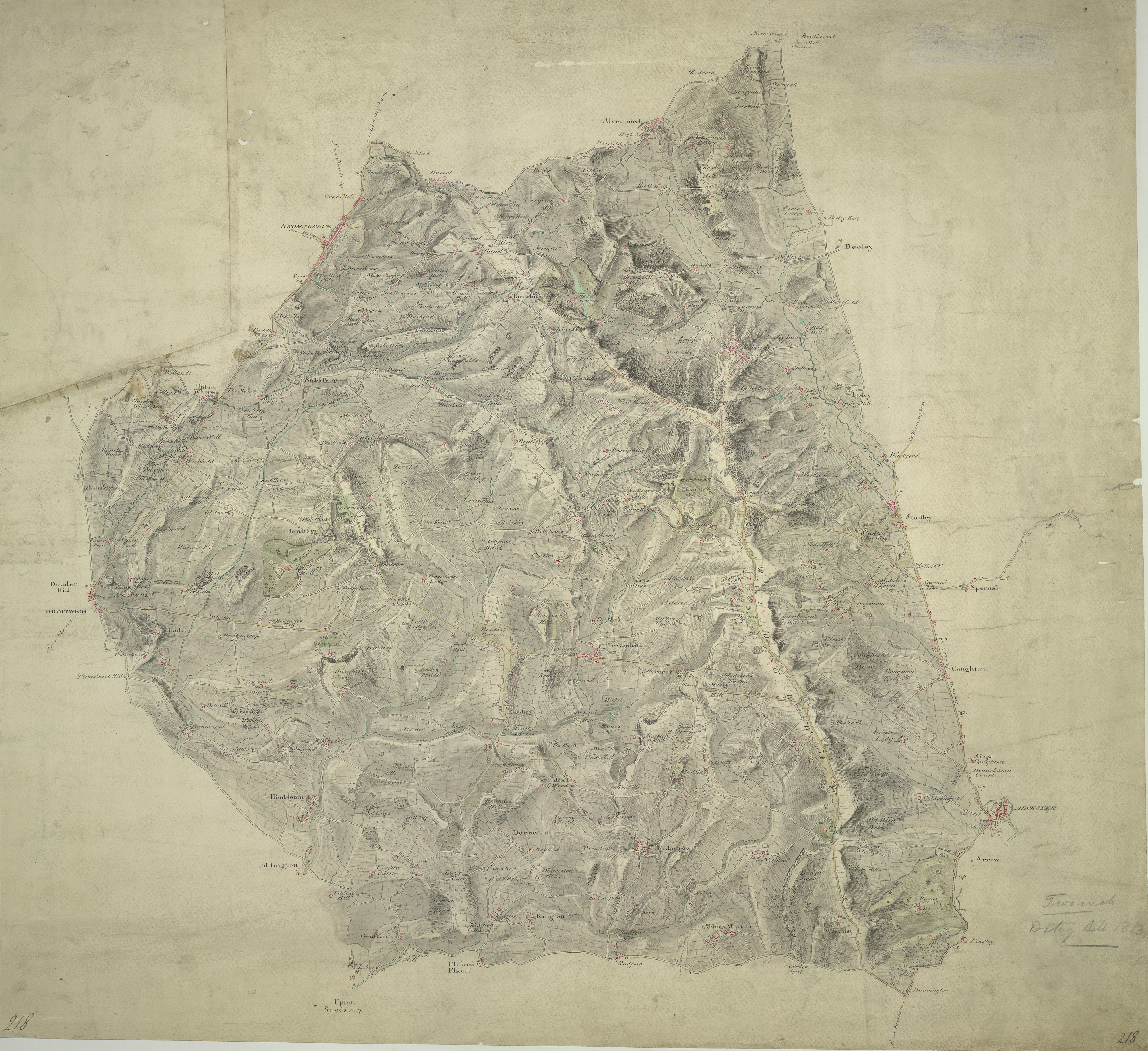
 Centre of map shown on a map of England
English: .This map covers part of Worcestershire., The right-hand boundary of the plan is formed by a Roman road, Ikenild Street., Another such road, the Salt Way, is drawn across the middle of the sheet., In Roman times, this road connected the salt mines at Droitwich,,near the top right, with Alcester, at the bottom. .Outside Alcester is Ragley Hall, designed in 1680 by Robert Hooke (1635-1703), the eminent natural philosopher and Surveyor of the City of London after the Great Fire of 1666., The landscaped gardens were added in the 18th century by Lancelot 'Capability' Brown (1716-1783) - so called because he often told prospective clients that their gardens had "great capabilities"., Brown and his followers revolutionised parkland design, virtually inventing the English parkland as we know it today, with carefully planned vistas of grassland, trees and lakes..
This image has been georeferenced.
|
||||
| Language |
English |
||||
| Date | 1813 | ||||
| Medium | Pen and ink on paper | ||||
| Dimensions | 320 × 300 mm (12.59 × 11.81 in) | ||||
| Collection | |||||
| Accession number |
Maps OSD 218 |
||||
| Credit line | British Library | ||||
| Notes |
Scale 2 inches : 1 mile (1:31680). Please note that the British Library provides these digital files "as-is"; materials will not be rephotographed under this programme. If resupply of files is required, the requestor will be required to purchase them at the standard rate. |
||||
| References |
http://www.bl.uk/onlinegallery/onlineex/ordsurvdraw/t/002osd000000003u00177000.html (English) |
||||
| Source/Photographer |
|
||||
| Permission (Reusing this file) |
|
||||


_(St_Edwards_Crown).svg)
.jpg¶ms=52.277731_N_-1.99706_E_)
.jpg¶ms=52.174178_N_-2.188429_E_)
.jpg¶ms=52.381284_N_-1.805691_E_)
.jpg¶ms=52.381284_N_-2.151029_E_)
.jpg¶ms=52.18708_N_-2.188429_E_)
.jpg¶ms=52.174178_N_-1.843091_E_)
.jpg¶ms=52.368381_N_-1.805691_E_)
File history
Click on a date/time to view the file as it appeared at that time.
| Date/Time | Thumbnail | Dimensions | User | Comment | |
|---|---|---|---|---|---|
| current | 09:44, 26 September 2013 | | 4,000 × 3,663 (5.01 MB) | LibraryBot (talk | contribs) | {{subst:User:Andrew Gray/OSD|ID= 002OSD000000003U00177000 |OSD_NUM= OSD 218 |MEDIUM= Pen and ink on paper |TITLE= Tardebigge, Worcestershire |CREATOR= Dawson, Robert - Draughtsman |YEAR= 1813 |DESCRIPTION= .This map covers part of Worcestershire., The ... |
You cannot overwrite this file.
File usage on Commons
The following page uses this file:
File usage on other wikis
The following other wikis use this file:
- Usage on www.wikidata.org
.jpg&oldid=907058522)