File:Ordnance Survey Drawings - Tenby (OSD 181).jpg
Jump to navigation
Jump to search
Size of this preview: 387 × 599 pixels. Other resolutions: 155 × 240 pixels | 310 × 480 pixels | 496 × 768 pixels | 662 × 1,024 pixels | 1,323 × 2,048 pixels | 2,585 × 4,000 pixels.
Original file (2,585 × 4,000 pixels, file size: 3.64 MB, MIME type: image/jpeg)
Captions
Captions
Add a one-line explanation of what this file represents
| Tenby (OSD 181)
|
|||||
|---|---|---|---|---|---|
| Artist |
[Budgen, Thomas] - Draughtsman |
.jpg) | |||
| Title |
Ordnance Survey Drawings: Tenby (OSD 181) |
||||
| Object type |
manuscript map |
||||
| Description |
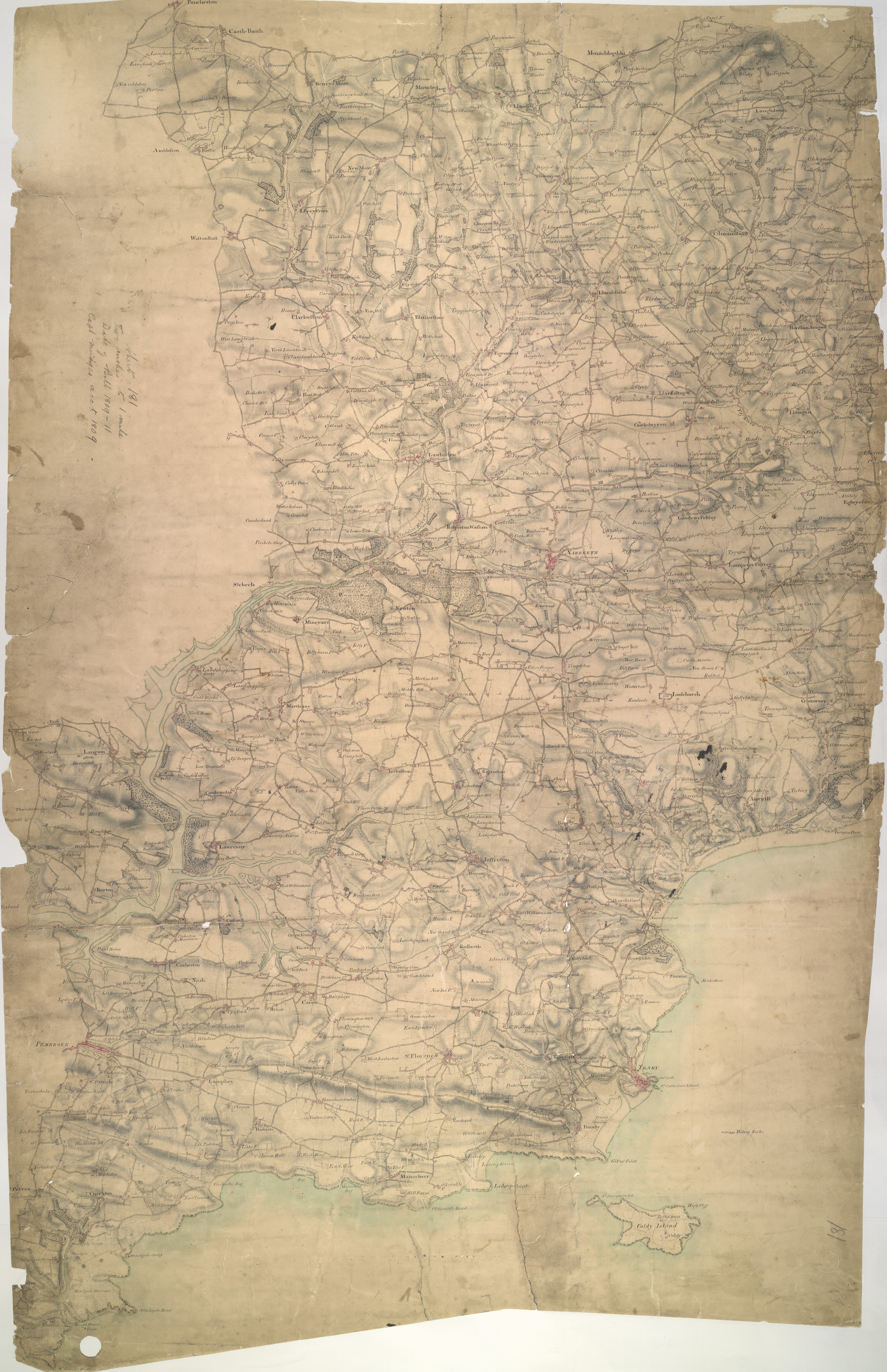
 Centre of map shown on a map of England
English: This plan of the Pembrokeshire coast shows the deep-sea port of Tenby at lower right and the River Cleddau Valley, with its broad tidal estuary flowing into Milford Haven, at lower left. Tidal rivers, called 'pills' on this plan, are a peculiar feature of the south Pembrokeshire landscape. Along the banks of one of the pills is the small settlement of Carew with the remains of an 11th-century castle and tidal mill indicated..
This image has been georeferenced.
|
||||
| Language |
English |
||||
| Date | 1809 | ||||
| Medium | Pen and ink on paper | ||||
| Dimensions | height: 480 mm (18.89 in); width: 310 mm (12.20 in) | ||||
| Collection | |||||
| Accession number |
Maps OSD 181 |
||||
| Credit line | British Library | ||||
| Notes |
Scale 2 inches : 1 mile (1:31680). Please note that the British Library provides these digital files "as-is"; materials will not be rephotographed under this programme. If resupply of files is required, the requestor will be required to purchase them at the standard rate. |
||||
| References |
http://www.bl.uk/onlinegallery/onlineex/ordsurvdraw/t/002osd000000021u00138000.html (English) |
||||
| Source/Photographer |
|
||||
| Permission (Reusing this file) |
|
||||


_(St_Edwards_Crown).svg)
.jpg¶ms=51.766338_N_-4.783403_E_)
.jpg¶ms=51.595827_N_-4.969312_E_)
.jpg¶ms=51.936848_N_-4.597494_E_)
.jpg¶ms=51.929846_N_-4.969312_E_)
.jpg¶ms=51.595827_N_-4.947353_E_)
.jpg¶ms=51.602829_N_-4.597494_E_)
.jpg¶ms=51.936848_N_-4.619453_E_)
File history
Click on a date/time to view the file as it appeared at that time.
| Date/Time | Thumbnail | Dimensions | User | Comment | |
|---|---|---|---|---|---|
| current | 08:42, 26 September 2013 | | 2,585 × 4,000 (3.64 MB) | LibraryBot (talk | contribs) | {{subst:User:Andrew Gray/OSD|ID= 002OSD000000021U00138000 |OSD_NUM= OSD 181 |MEDIUM= Pen and ink on paper |TITLE= Tenby |CREATOR= [Budgen, Thomas] - Draughtsman |YEAR= 1809 |DESCRIPTION= This plan of the Pembrokeshire coast shows the deep-sea port o... |
You cannot overwrite this file.
File usage on Commons
The following page uses this file:
File usage on other wikis
The following other wikis use this file:
- Usage on www.wikidata.org
.jpg&oldid=915921267)