File:Ordnance Survey Drawings - Worminghall (OSD 156).jpg
Jump to navigation
Jump to search
Size of this preview: 689 × 599 pixels. Other resolutions: 276 × 240 pixels | 552 × 480 pixels | 883 × 768 pixels | 1,177 × 1,024 pixels | 2,355 × 2,048 pixels | 4,000 × 3,479 pixels.
Original file (4,000 × 3,479 pixels, file size: 5.52 MB, MIME type: image/jpeg)
Captions
Captions
Add a one-line explanation of what this file represents
| Worminghall (OSD 156)
|
|||||
|---|---|---|---|---|---|
| Artist |
Stanley, William - Draughtsman |
.jpg) | |||
| Title |
Ordnance Survey Drawings: Worminghall (OSD 156) |
||||
| Object type |
manuscript map |
||||
| Description |
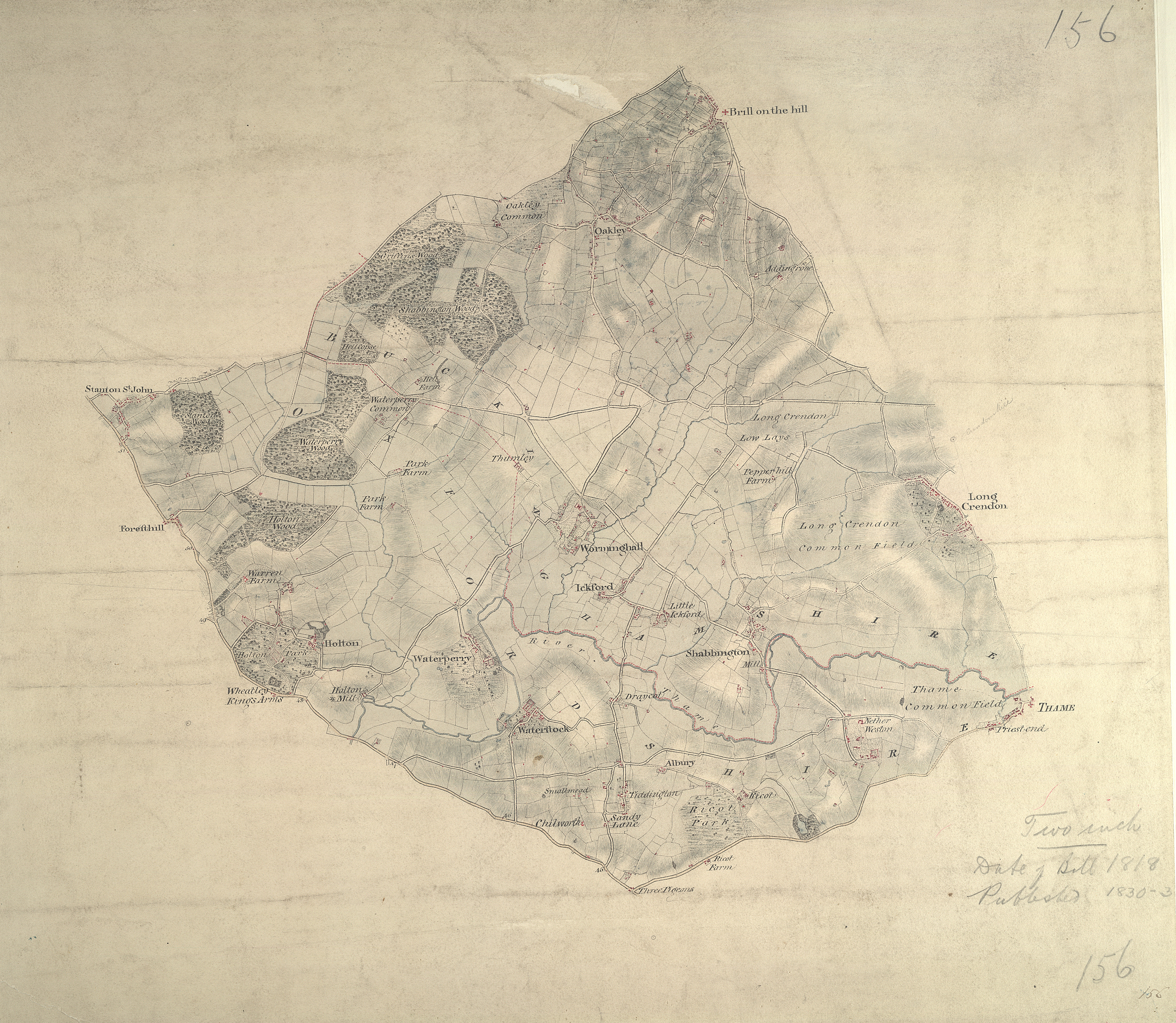
 Centre of map shown on a map of England
English: The border between Buckinghamshire and Oxfordshire is drawn as a red dashed line along the path of the River Thame, near the bottom of the map., Worminghall is on the Buckinghamshire side of the border., Soft pencil rays criss-cross the map, used by the surveyor when taking measurements between fixed points., These are most clearly visible at 'Brill on the Mill' near the top of the plan..
This image has been georeferenced.
|
||||
| Language |
English |
||||
| Date | 1818 | ||||
| Medium | Pen and ink on paper | ||||
| Dimensions | 220 × 100 mm (8.66 × 3.93 in) | ||||
| Collection | |||||
| Accession number |
Maps OSD 156 |
||||
| Credit line | British Library | ||||
| Notes |
Scale 2 inches : 1 mile (1:31680). Please note that the British Library provides these digital files "as-is"; materials will not be rephotographed under this programme. If resupply of files is required, the requestor will be required to purchase them at the standard rate. |
||||
| References |
http://www.bl.uk/onlinegallery/onlineex/ordsurvdraw/w/002osd000000002u00109000.html (English) |
||||
| Source/Photographer |
|
||||
| Permission (Reusing this file) |
|
||||


_(St_Edwards_Crown).svg)
.jpg¶ms=51.774784_N_-1.073139_E_)
.jpg¶ms=51.715281_N_-1.181441_E_)
.jpg¶ms=51.834287_N_-0.964837_E_)
.jpg¶ms=51.825367_N_-1.181441_E_)
.jpg¶ms=51.715281_N_-1.168591_E_)
.jpg¶ms=51.724201_N_-0.964837_E_)
.jpg¶ms=51.834287_N_-0.977687_E_)
File history
Click on a date/time to view the file as it appeared at that time.
| Date/Time | Thumbnail | Dimensions | User | Comment | |
|---|---|---|---|---|---|
| current | 08:04, 26 September 2013 | | 4,000 × 3,479 (5.52 MB) | LibraryBot (talk | contribs) | {{subst:User:Andrew Gray/OSD|ID= 002OSD000000002U00109000 |OSD_NUM= OSD 156 |MEDIUM= Pen and ink on paper |TITLE= Worminghall |CREATOR= Stanley, William - Draughtsman |YEAR= 1818 |DESCRIPTION= The border between Buckinghamshire and Oxfordshire is drawn... |
You cannot overwrite this file.
File usage on Commons
The following page uses this file:
File usage on other wikis
The following other wikis use this file:
- Usage on www.wikidata.org
.jpg&oldid=889285923)