File:Orient-Express 1945-1962.png
Jump to navigation
Jump to search

Size of this preview: 787 × 600 pixels. Other resolutions: 315 × 240 pixels | 630 × 480 pixels | 1,008 × 768 pixels | 1,280 × 975 pixels | 2,366 × 1,803 pixels.
Original file (2,366 × 1,803 pixels, file size: 3.64 MB, MIME type: image/png)
Captions
Captions
Add a one-line explanation of what this file represents
Summary
[edit]| Description |
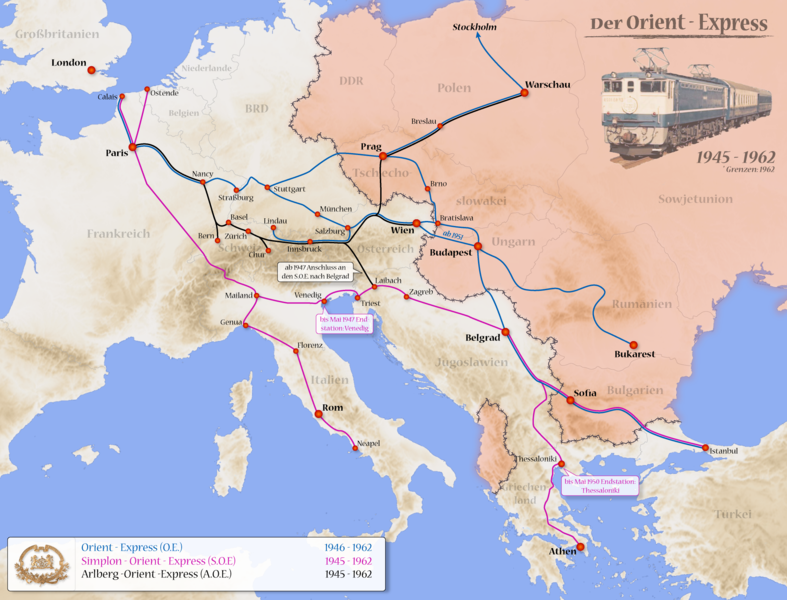
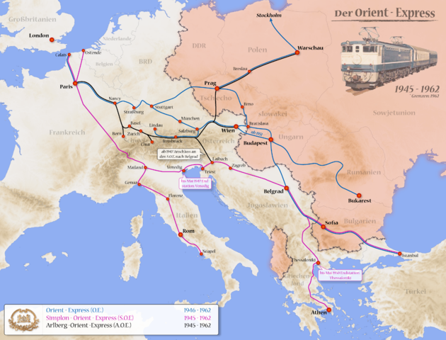
Deutsch: Karte des Orient Expresses von 1945 bis 1962
English: Route of the Orient Express from 1945 to 1962 |
| Date | |
| Source |
eigene Arbeit used this source: Generic Mapping Tools with ETOPO2v2-Dates
|
| Author | Devilm25 |
| Other versions |
|


|
This map has been made or improved in the German Kartenwerkstatt (Map Lab). You can propose maps to improve as well.
|
|
This map results from a map request to the Kartenwünsche in the Kartenwerkstatt. You can make as well a request for a new map.
|
Licensing
[edit]
I, the copyright holder of this work, hereby publish it under the following licenses:

|
Permission is granted to copy, distribute and/or modify this document under the terms of the GNU Free Documentation License, Version 1.2 or any later version published by the Free Software Foundation; with no Invariant Sections, no Front-Cover Texts, and no Back-Cover Texts. A copy of the license is included in the section entitled GNU Free Documentation License. |
This file is licensed under the Creative Commons Attribution 3.0 Unported license.
- You are free:
- to share – to copy, distribute and transmit the work
- to remix – to adapt the work
- Under the following conditions:
- attribution – You must give appropriate credit, provide a link to the license, and indicate if changes were made. You may do so in any reasonable manner, but not in any way that suggests the licensor endorses you or your use.
You may select the license of your choice.
File history
Click on a date/time to view the file as it appeared at that time.
| Date/Time | Thumbnail | Dimensions | User | Comment | |
|---|---|---|---|---|---|
| current | 08:55, 21 May 2008 | | 2,366 × 1,803 (3.64 MB) | Devilm25 (talk | contribs) | == Beschreibung == {{Information |Description= *{{en}}Route of the Orient Express from 1945 to 1962 *{{de}}Karte des Orient Expresses von 1945 bis 1962 |Source=eigene Arbeit used this source: Generic Mapping Tools with [http: |
You cannot overwrite this file.
File usage on Commons
There are no pages that use this file.
File usage on other wikis
The following other wikis use this file:
- Usage on cs.wikipedia.org
- Usage on de.wikipedia.org
- Usage on ja.wikipedia.org
- Usage on ko.wikipedia.org
- Usage on sk.wikipedia.org
- Usage on zh.wikipedia.org