File:Pařížský mír.png
Jump to navigation
Jump to search
Size of this preview: 464 × 600 pixels. Other resolutions: 186 × 240 pixels | 619 × 800 pixels.
Original file (619 × 800 pixels, file size: 23 KB, MIME type: image/png)
Captions
Captions
Add a one-line explanation of what this file represents
Summary
[edit]| Description |
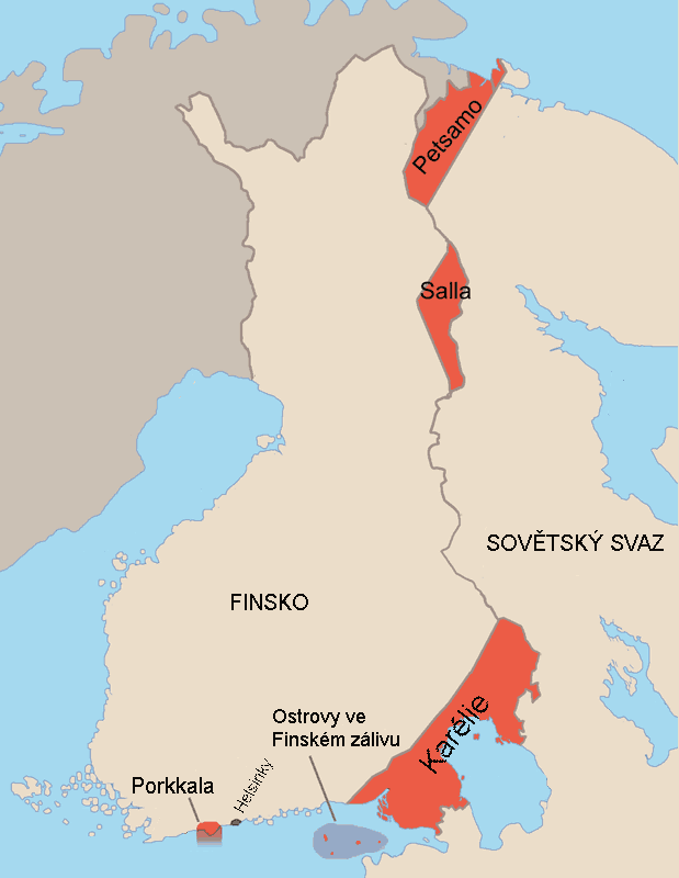
Čeština: Mapa finsko-ruské hranice po Pařížském míru. |
| Date | |
| Source | |
| Author | Jniemenmaa |
| Other versions |
[]
|


.png)


|
This locator map image could be re-created using vector graphics as an SVG file. This has several advantages; see Commons:Media for cleanup for more information. If an SVG form of this image is available, please upload it and afterwards replace this template with
{{vector version available|new image name}}.
It is recommended to name the SVG file “Pařížský mír.svg”—then the template Vector version available (or Vva) does not need the new image name parameter. |
Licensing
[edit]

|
Permission is granted to copy, distribute and/or modify this document under the terms of the GNU Free Documentation License, Version 1.2 or any later version published by the Free Software Foundation; with no Invariant Sections, no Front-Cover Texts, and no Back-Cover Texts. A copy of the license is included in the section entitled GNU Free Documentation License. |
| This file is licensed under the Creative Commons Attribution-Share Alike 3.0 Unported license. | ||
| ||
| This licensing tag was added to this file as part of the GFDL licensing update. |
Original upload log
[edit]
Transferred from cs.wikipedia to Commons by Faigl.ladislav using CommonsHelper.
The original description page was here. All following user names refer to cs.wikipedia.
- 2005-09-09 14:29 Miraceti 619×800× (23882 bytes) Mapa finsko-ruské hranice po [[Pařížský mír|Pařížském míru]]. Originál: [[:fi:Kuva:Pariisin rauha.png]], autor:[[:fi:Käyttäjä:Jniemenmaa]] Upravil: [[Wikipedista:Miraceti]].
- 2005-09-09 14:21 Miraceti 619×800× (23503 bytes) Mapa finsko-ruské hranice po [[Pařížský mír|Pařížském míru]]. Originál: [[:fi:Kuva:Pariisin rauha.png]], autor:[[:fi:Käyttäjä:Jniemenmaa]] Upravil: [[Wikipedista:Miraceti]].
File history
Click on a date/time to view the file as it appeared at that time.
| Date/Time | Thumbnail | Dimensions | User | Comment | |
|---|---|---|---|---|---|
| current | 14:19, 24 June 2010 | | 619 × 800 (23 KB) | File Upload Bot (Magnus Manske) (talk | contribs) | {{BotMoveToCommons|cs.wikipedia|year={{subst:CURRENTYEAR}}|month={{subst:CURRENTMONTHNAME}}|day={{subst:CURRENTDAY}}}} {{Information |Description={{cs|Mapa finsko-ruské hranice po Pařížském míru. Originál: [[:cs::fi:Kuva |
You cannot overwrite this file.
File usage on Commons
The following 22 pages use this file:
- File:Bellum Hiemale 1.PNG
- File:Elcsatolt finn területek1940.png
- File:Finnische abgetretene Gebiete 1940.png
- File:Finnische abgetretene Gebiete 1944.png
- File:Finnish areas ceded in 1940-IT.png
- File:Finnish areas ceded in 1940-ar.jpg
- File:Finnish areas ceded in 1940-es.svg
- File:Finnish areas ceded in 1940.png
- File:Finnish areas ceded in 1940 RUS.png
- File:Finnish areas ceded in 1940 RUS (1).png
- File:Finnish areas ceded in 1940 UKR.png
- File:Finnish areas ceded in 1944-ar.png
- File:Finnish areas ceded in 1944.png
- File:Moskevský mír.png
- File:Moskovan rauha-et.png
- File:Moskovan rauha.png
- File:Pariisin rauha.png
- File:Pariisin rauha de.png
- File:Pařížský mír.png
- File:Territoires finlandais cédés en 1940.png
- File:Territoires finlandais cédés en 1944.png
- Template:Other versions/Finnish cessiations to the Soviet Union
File usage on other wikis
The following other wikis use this file:
- Usage on cs.wikipedia.org
- Usage on he.wikipedia.org