File:Pacific Ring of Fire-uk.svg

Original file (SVG file, nominally 942 × 569 pixels, file size: 262 KB)
Captions
Captions
Summary
[edit]| DescriptionPacific Ring of Fire-uk.svg |
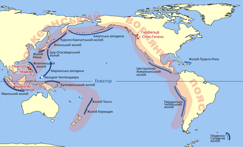
Українська: На мапі позначені:
Тихоокеанський вогняний пояс. Океанічні жолоби навколо нього. Найбільші вулкани на поясі. Безодня Челленджера. (Найглибша точка світового океану) |
| Date | |
| Source |
This file was derived from: Pacific Ring of Fire.svg |
| Author |
|
| Other versions |
[edit]
|
Licensing
[edit]| Public domainPublic domainfalsefalse |
| I, the copyright holder of this work, release this work into the public domain. This applies worldwide. In some countries this may not be legally possible; if so: I grant anyone the right to use this work for any purpose, without any conditions, unless such conditions are required by law. |
File history
Click on a date/time to view the file as it appeared at that time.
| Date/Time | Thumbnail | Dimensions | User | Comment | |
|---|---|---|---|---|---|
| current | 20:25, 11 February 2022 |  | 942 × 569 (262 KB) | SerhiyHelp (talk | contribs) | Uploaded own work with UploadWizard |
You cannot overwrite this file.
File usage on Commons
The following 7 pages use this file:
File usage on other wikis
The following other wikis use this file:
- Usage on uk.wikipedia.org
Metadata
This file contains additional information such as Exif metadata which may have been added by the digital camera, scanner, or software program used to create or digitize it. If the file has been modified from its original state, some details such as the timestamp may not fully reflect those of the original file. The timestamp is only as accurate as the clock in the camera, and it may be completely wrong.
| Short title | World Databank II 2 SVG converter |
|---|---|
| Image title | World Map Image derived from WDB, using David Eccles (gringer)'s converter |
| Width | 942 |
| Height | 569 |


