File:Paris Metro map.svg
From Wikimedia Commons, the free media repository
Jump to navigation
Jump to search

Size of this PNG preview of this SVG file: 653 × 600 pixels. Other resolutions: 261 × 240 pixels | 523 × 480 pixels | 836 × 768 pixels | 1,115 × 1,024 pixels | 2,230 × 2,048 pixels | 1,927 × 1,770 pixels.
Original file (SVG file, nominally 1,927 × 1,770 pixels, file size: 309 KB)
File information
Structured data
Captions
Captions
Add a one-line explanation of what this file represents
| DescriptionParis Metro map.svg |
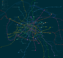
English: Paris metro network pictured at a geographically accurate scale.
Français : Plan du métro de Paris en repectant les proportions géographiques.
Русский: Карта парижского метрополитена и сети RER в географическом масштабе. |
|||
| Date | ||||
| Source | Vectorisation of Image:Paris Metro map.gif | |||
| Author | User:Pmx | |||
| Permission (Reusing this file) |
|
|||
| Other versions |
  |
This W3C-unspecified vector image was created with Inkscape .
This image was improved or created by the Wikigraphists of the Graphic Lab (fr). You can propose images to clean up, improve, create or translate as well. |
File history
Click on a date/time to view the file as it appeared at that time.
| Date/Time | Thumbnail | Dimensions | User | Comment | |
|---|---|---|---|---|---|
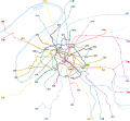
| current | 08:35, 14 May 2022 |  | 1,927 × 1,770 (309 KB) | Lyon-St-Clair (talk | contribs) | New line signs since 2019/2020 |
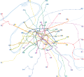
| 09:33, 18 January 2021 |  | 1,927 × 1,770 (326 KB) | Julio974fr (talk | contribs) | New extensions | |
| 11:25, 10 January 2010 |  | 1,927 × 1,770 (342 KB) | Greenski (talk | contribs) | Using of the goods paris metro signs, changing rer A color. | |
| 00:54, 22 June 2008 |  | 1,927 × 1,770 (321 KB) | Gonioul (talk | contribs) | split to multiple layers, thickens metro paths | |
| 22:16, 21 June 2008 |  | 1,927 × 1,770 (222 KB) | Gonioul (talk | contribs) | grey background is bad for readability | |
| 18:46, 13 June 2008 |  | 1,927 × 1,770 (222 KB) | Otourly (talk | contribs) | Mise à jour | |
| 20:59, 13 July 2007 |  | 1,927 × 1,770 (219 KB) | Pmx (talk | contribs) | {{Information |Description= {{en|Paris metro network pictured at a geographically accurate scale.}} {{fr|Plan du métro de Paris en vrai grandeur.}} |Source=Vectorisation of Image:Paris Metro map.gif |Date=13/07/07 |Author=User:Pmx |Permission=PD |
You cannot overwrite this file.
File usage on Commons
The following 11 pages use this file:
- Maps of Paris
- Paris Metro
- User:Chumwa/OgreBot/Public transport information/2021 January 11-20
- User:Chumwa/OgreBot/Public transport information/2022 May 11-20
- User:Chumwa/OgreBot/Transport Maps/2021 January 11-20
- User:Chumwa/OgreBot/Transport Maps/2022 May 11-20
- User:Paris 16/Paris
- User talk:Pi.1415926535/Archive 1
- File:Paris Metro map.gif
- File:Paris Metro map beschriftet.png
- File:Paris Metro map complete.svg
File usage on other wikis
The following other wikis use this file:
- Usage on cs.wikipedia.org
- Usage on de.wikipedia.org
- Usage on fr.wikipedia.org
- Portail:Transports en Île-de-France
- Portail:Transports en Île-de-France/Introduction
- Portail:Transports en Île-de-France/Métro
- Wikipédia:Atelier graphique/Images à améliorer/Archives/Juin 2008
- Wikipédia:Atelier graphique/Cartes/Archives/Demandes mises en sommeil
- Wikipédia:Atelier graphique/Cartes/Archives/juillet 2009
- Réseau (homonymie)
- Wikipédia:Atelier graphique/Cartes/Archives/juin 2016
- Usage on pl.wikipedia.org
- Usage on zh.wikipedia.org
Metadata
This file contains additional information such as Exif metadata which may have been added by the digital camera, scanner, or software program used to create or digitize it. If the file has been modified from its original state, some details such as the timestamp may not fully reflect those of the original file. The timestamp is only as accurate as the clock in the camera, and it may be completely wrong.
| Width | 1927 |
|---|---|
| Height | 1770 |