File:Partitioned Poland & the 2nd Republic (1772-1939).png
Jump to navigation
Jump to search
Size of this preview: 753 × 600 pixels. Other resolutions: 301 × 240 pixels | 603 × 480 pixels | 964 × 768 pixels | 1,280 × 1,019 pixels | 1,906 × 1,518 pixels.
Original file (1,906 × 1,518 pixels, file size: 443 KB, MIME type: image/png)
Captions
Captions
Add a one-line explanation of what this file represents
| Description |
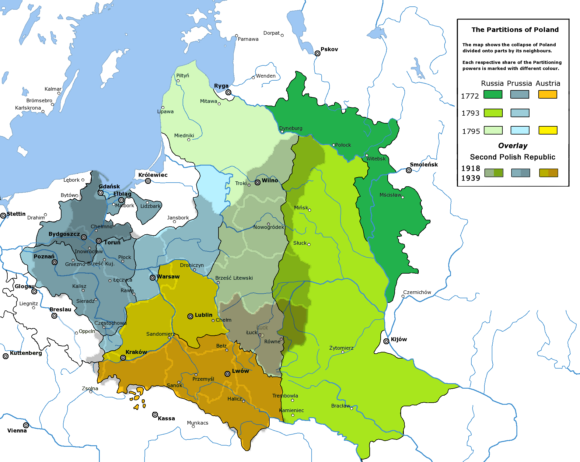
English: Partitions of the Polish-Lithuanian Commonwealth in 1772, 1793 and 1795, overlaid with the borders of the Second Polish Republic, 1918-1939, with the Volhynian Voivodeship (1921–1939) highlighted in pastel burgundy. |
| Date | |
| Source | |
| Author |
|
| Permission (Reusing this file) |
PD-Self |
| Other versions |
  |
| This is a retouched picture, which means that it has been digitally altered from its original version. Modifications: new colours. The original can be viewed here: Rzeczpospolita Rozbiory 3.png:
|

|
This historical map image could be re-created using vector graphics as an SVG file. This has several advantages; see Commons:Media for cleanup for more information. If an SVG form of this image is available, please upload it and afterwards replace this template with
{{vector version available|new image name}}.
It is recommended to name the SVG file “Partitioned Poland & the 2nd Republic (1772-1939).svg”—then the template Vector version available (or Vva) does not need the new image name parameter. |
I, the copyright holder of this work, hereby publish it under the following license:

|
Permission is granted to copy, distribute and/or modify this document under the terms of the GNU Free Documentation License, Version 1.2 or any later version published by the Free Software Foundation; with no Invariant Sections, no Front-Cover Texts, and no Back-Cover Texts. A copy of the license is included in the section entitled GNU Free Documentation License. |
| This file is licensed under the Creative Commons Attribution-Share Alike 3.0 Unported license. | ||
| ||
| This licensing tag was added to this file as part of the GFDL licensing update. |
Original upload log
[edit].png&action=edit§ion=1)
This image is a derivative work of the following images:
- File:Partitions of Poland.png
- File:Rzeczpospolita_Rozbiory_3.png licensed with GFDL
- 2006-02-16T21:06:11Z Tomekpe 2000x1568 (246810 Bytes) Corrected mistakes: * Silesia at the time belonged to Prussia, whereas the map shows it belonging to Austria.
- 2005-12-25T21:52:24Z Tomekpe 2000x1568 (247161 Bytes) Halibutt's graphic with changing polish-russian border (Krasny Horodok area).
- 2005-01-10T13:41:59Z Halibutt 2000x1568 (343225 Bytes) Partitions of the [[Polish-Lithuanian Commonwealth]]{{User:Halibutt/maps}}{{User:Halibutt/GFDL}}[[Category:Maps of Poland]][[Category:Historical maps]]
Uploaded with derivativeFX
File history
Click on a date/time to view the file as it appeared at that time.
| Date/Time | Thumbnail | Dimensions | User | Comment | |
|---|---|---|---|---|---|
| current | 06:11, 26 February 2017 | | 1,906 × 1,518 (443 KB) | Poeticbent (talk | contribs) | {{Information |Description={{en|Partitions of the Polish-Lithuanian Commonwealth in 1772, 1793 and 1795, overlaid with the borders of the Second Polish Republic, 1918-1939, with the Volhynian Voivodeship (1921–1939) highlighted in pastel burgundy... |
You cannot overwrite this file.
File usage on Commons
There are no pages that use this file.
File usage on other wikis
The following other wikis use this file:
- Usage on en.wikipedia.org
- Usage on kaa.wikipedia.org
- Usage on lt.wikipedia.org
- Usage on lt.wikibooks.org
- Usage on uz.wikipedia.org
.png&oldid=606474798)