File:Plan Odendaal-fr.png
Jump to navigation
Jump to search
No higher resolution available.
Plan_Odendaal-fr.png (418 × 418 pixels, file size: 19 KB, MIME type: image/png)
Captions
Captions
Add a one-line explanation of what this file represents
Summary
[edit]
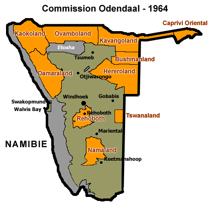
| Description | This map in French shows the Odendaal Commission Plan for Namibia of 1964. The plan divided Namibia into Bantustans or Homelands. |
| Date |
Original file : April 2005 Translation : August 2006 |
| Source | Image:Plan_Odendaal.png created by Bries |
| Author |
Original file : Bries Translation : Sting |
| Permission (Reusing this file) |
GFDL |
| Other versions | in English : Image:Plan_Odendaal.png |
Français : * Sujet : Carte en français du plan de la Commission Odendaal de 1964 pour la Namibie. Le plan divisait le pays en Bantoustans ou Homelands. ;
- Source : Image:Plan_Odendaal.png créée par Bries ;
- Auteurs :
- Date :
- image originale : Avril 2005 ;
- traduction : Août 2006.
Licensing
[edit]
| This file is licensed under the Creative Commons Attribution-Share Alike 3.0 Unported license. Subject to disclaimers. | ||
| ||
| This licensing tag was added to this file as part of the GFDL licensing update. |

|
Permission is granted to copy, distribute and/or modify this document under the terms of the GNU Free Documentation License, Version 1.2 or any later version published by the Free Software Foundation; with no Invariant Sections, no Front-Cover Texts, and no Back-Cover Texts. A copy of the license is included in the section entitled GNU Free Documentation License. Subject to disclaimers. |
File history
Click on a date/time to view the file as it appeared at that time.
| Date/Time | Thumbnail | Dimensions | User | Comment | |
|---|---|---|---|---|---|
| current | 14:08, 28 August 2006 | | 418 × 418 (19 KB) | Sting (talk | contribs) | Translated map |
| 17:21, 24 June 2006 |  | 418 × 418 (15 KB) | Chris93 (talk | contribs) | This map shows the Odendaal Commission Plan for Namibia of 1964. The plan divided Namibia into ''Bantustans'' or ''Homelands''. Traduction en attente de Image:Plan_Odendaal.png I have created the map for the Wikipedia community. [[Category:Maps of |
You cannot overwrite this file.
File usage on Commons
There are no pages that use this file.
File usage on other wikis
The following other wikis use this file:
- Usage on ca.wikipedia.org
- Usage on fr.wikipedia.org