File:Plan de Paris 1657.jpg
Jump to navigation
Jump to search

Size of this preview: 775 × 600 pixels. Other resolutions: 310 × 240 pixels | 620 × 480 pixels | 993 × 768 pixels | 1,280 × 990 pixels | 2,560 × 1,981 pixels | 3,342 × 2,586 pixels.
Original file (3,342 × 2,586 pixels, file size: 10.13 MB, MIME type: image/jpeg)
Captions
Captions
Add a one-line explanation of what this file represents
Summary
[edit]| Title |
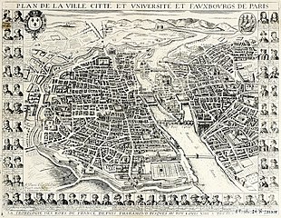
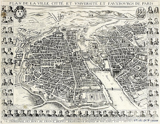
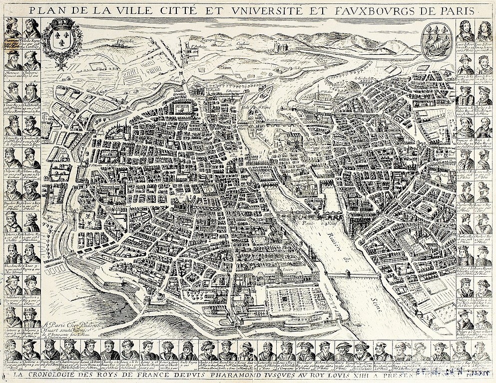
Plan de la ville, cité et université et faubourgs de Paris : 1657 |
||||
| Description |
Français : Imitation du plan de Mérian représentant Paris en 1657 |
||||
| Date | |||||
| Source |
Deutsch: Die Bilder enstanden anläßlich eines Workshops im Rahmen von Skillshare 2010 in Zusammenarbeit mit dem Stadtarchiv Lüneburg. Die Originale wurden freundlicherweise vom Stadtarchiv zur Verfügung gestellt - Joergens.mi |
||||
| Creator |
Bertrant, Pierre |
||||
| Geotemporal data | |||||
| Map location | Paris | ||||
| Bounding box |
|
||||
| Georeferencing | If inappropriate please set warp_status = skip to hide. | ||||
| Bibliographic data | |||||
| Place of publication | Paris | ||||
| Publisher |
chez Pierre Bertrant (rue St Jacques, à la Pomme d'or) |
||||
| Archival data | |||||
| Dimensions | 525 x 400 mm | ||||
| Notes |
Français : A gauche, en bas, et à droite, 65 portraits de rois de France avec le nombre d'années de leur règne et le lieu de leur sépulture : en bas : "La cronologie des roys de France depuis Pharamond jusques au roy Louis XIIII a present regnent. 1657".- En haut à gauche écu de France, à droite, blason de Paris |
||||
| artwork-references | Bibliothèque spécialisée de la Ville de Paris | ||||

Licensing
[edit]
|
This work is in the public domain in its country of origin and other countries and areas where the copyright term is the author's life plus 100 years or fewer. | |
| This file has been identified as being free of known restrictions under copyright law, including all related and neighboring rights. | |
File history
Click on a date/time to view the file as it appeared at that time.
| Date/Time | Thumbnail | Dimensions | User | Comment | |
|---|---|---|---|---|---|
| current | 17:37, 22 September 2017 | | 3,342 × 2,586 (10.13 MB) | Paris 16 (talk | contribs) | |
| 09:12, 27 October 2011 |  | 3,342 × 2,586 (7.62 MB) | Paris 16 (talk | contribs) |
You cannot overwrite this file.
File usage on Commons
There are no pages that use this file.
File usage on other wikis
The following other wikis use this file:
- Usage on de.wikipedia.org