File:Polish-Lithuania map (1450-1600).svg
Jump to navigation
Jump to search

Size of this PNG preview of this SVG file: 458 × 599 pixels. Other resolutions: 183 × 240 pixels | 367 × 480 pixels | 587 × 768 pixels | 782 × 1,024 pixels | 1,565 × 2,048 pixels | 726 × 950 pixels.
Original file (SVG file, nominally 726 × 950 pixels, file size: 72 KB)
Captions
Captions
Add a one-line explanation of what this file represents
Summary
[edit].svg&action=edit§ion=1)
| Description |
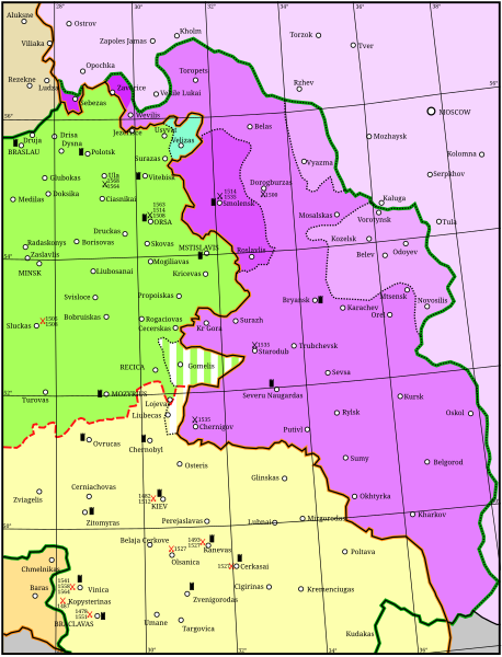
English: Map showing the conflicts and territory of the union (later commonwealth) of Poland-Lithuania.
National border
Administrative or temporal division
The Grand Duchy of Lithuania in 1450
Livonia
Other rule
Russia before 1494
Significant battles fought by Poland-Lithuania. Red: against the Tartars; Black: against Russia. Year given in small type.
Significant fortress |
| Date | |
| Source | Own work |
| Author | Grandiose, adapted considerably from: (2001) Lietuvos istorijos atlasas, Vilnius: Vaga, pp. 16-17 ISBN 5-415-01577-9 |
| File | Type | Details |
|---|---|---|
| File:Polish-Lithuania map (1450-1600).svg | Large SVG | Map showing conflicts and territorial changes on the Polish-Lithuanian—Russian border, 1450–1600 |
| File:Duchy of Prussia.svg | Small SVG | Map of the Duchy of Prussia |
| File:Livonian war map (1558-1560).svg | Small SVG | Map showing campaigns in Livonia, 1558–1560. |
| File:Map of Poland and Lithuania after the Union of Lublin (1569).svg | Large SVG | Map of the w:Polish-Lithuanian Commonwealth after the Union of Lublin in 1569. |
| File:Livonian war map (1570-1577).svg | Small SVG | Map showing areas of Russian and Polish-Lithuanian forces, 1570–1577. |
| File:Campaigns of Stefan Batory.svg | Small SVG | Map of the campaign of Stefan Batory in Livonia (1575–1580). |
| File:Map of Poland and Lithuania in 1600.svg | Small SVG | Map of Livonia in 1600 |
| See also: User:Halibutt/maps, by Halibutt (talk · contribs). | ||
.svg)
.svg)
.svg)
Licensing
[edit].svg&action=edit§ion=2)
I, the copyright holder of this work, hereby publish it under the following license:
This file is licensed under the Creative Commons Attribution-Share Alike 3.0 Unported license.
- You are free:
- to share – to copy, distribute and transmit the work
- to remix – to adapt the work
- Under the following conditions:
- attribution – You must give appropriate credit, provide a link to the license, and indicate if changes were made. You may do so in any reasonable manner, but not in any way that suggests the licensor endorses you or your use.
- share alike – If you remix, transform, or build upon the material, you must distribute your contributions under the same or compatible license as the original.
File history
Click on a date/time to view the file as it appeared at that time.
| Date/Time | Thumbnail | Dimensions | User | Comment | |
|---|---|---|---|---|---|
| current | 18:02, 24 April 2011 | | 726 × 950 (72 KB) | Grandiose (talk | contribs) | Optimise |
| 18:42, 18 April 2011 |  | 726 × 950 (1.5 MB) | Grandiose (talk | contribs) | Longitude and latitude lines. | |
| 14:27, 18 April 2011 |  | 726 × 950 (233 KB) | Grandiose (talk | contribs) | Border change | |
| 13:45, 18 April 2011 |  | 726 × 950 (225 KB) | Grandiose (talk | contribs) | {{Information |Description ={{en|1=Map showing the conflicts and territory of the union (later commonwealth) of Poland-Lithuania.}} |Source ={{own}} |Author =Grandiose, adapted considerably from a Lithuanian historica |
You cannot overwrite this file.
File usage on Commons
There are no pages that use this file.
File usage on other wikis
The following other wikis use this file:
- Usage on et.wikipedia.org
- Usage on lt.wikipedia.org
.svg&oldid=647430179)