File:Polska kontur bialy.png
Jump to navigation
Jump to search
No higher resolution available.
Polska_kontur_bialy.png (378 × 372 pixels, file size: 6 KB, MIME type: image/png)
Captions
Captions
Add a one-line explanation of what this file represents

|
File:POL location map.svg is a vector version of this file. It should be used in place of this PNG file when not inferior.
File:Polska kontur bialy.png → File:POL location map.svg
For more information, see Help:SVG. |
 |
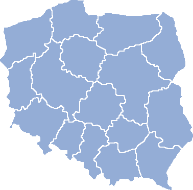
Contour map of administrative division of Poland since 1999, for use as a matrix for various locator maps (cities, regions, voivodships, landmarks).
Partial (far from complete) list of derivative images is available here and here.
| Contour maps of administrative division of Poland • AD 1939 • AD 1957 • AD 1975 • AD 1999 • dummy • blank • flag |

|
| Lingua | Quod | Quomodo | Quis | Varia | |
|---|---|---|---|---|---|
| English | Contour map of Poland, for use with various locator maps | To create a locator map just open the file and add a red dot where you want the town to appear. | Created by Halibutt in PSP and the GIMP | If you use the map, please provide a link to this page for the others to use it as well. Thanks in advance | |
| Polszczyzna | Mapa konturowa Polski, do przygotowywania mapek lokalizacyjnych miast i województw | By przygotować taką mapkę - zwyczajnie otwórz ten plik w dowolnym programie graficznym i wstaw czerwoną kropę w miejscu miasta | Autorstwo i narzędzia: Halibutt, PSP, GIMP | Jeśli używasz tej mapki do przygotowywania własnych - podaj proszę link do tej strony, by inni też mogli zeń skorzystać | |
| Castellano | Un mapa de Polonia, para crear varios mapas de localización de ciudades y voivodatos | Para usarlo editadlo con cualquier programa de edición de dibujos y poned un punto rojo | Creado por Halibutt con GIMP y PSP | Si les gusta este mapa, poned por favor un enlace a esta pagina para que otros lo usen tambien. |
Since the legal status of the above comment has been questioned, I hereby grant anyone the right to treat it as either a standard copyright notice, invariant section, legal statement, legal advice, friendly suggestion or a mere comment, depending on his or hers own choice. |
|

derivative works
[edit]
Derivative works of this file: Polska atlas wikipedystów na 100 000 mieszk. 2009.png
File history
Click on a date/time to view the file as it appeared at that time.
| Date/Time | Thumbnail | Dimensions | User | Comment | |
|---|---|---|---|---|---|
| current | 21:56, 25 February 2006 | | 378 × 372 (6 KB) | Halibutt (talk | contribs) | Transparent background |
| 16:35, 13 December 2004 |  | 395 × 396 (4 KB) | Halibutt (talk | contribs) | Contour map of Poland, for use with various locator maps<br>To create a locator map just open the file and add a red dot where you want the town to appear. <br><br>Created by Halibutt in PSP and the GIMP<br>{{User:Halibutt/GFDL}} |
You cannot overwrite this file.
File usage on Commons
The following 22 pages use this file:
- User:Halibutt/administrative
- File:Biecz położenie.png
- File:Poland administrative division 1922.png
- File:Poland administrative division 1957.PNG
- File:Poland administrative division 1975.png
- File:Poland dummy map.png
- File:Polska atlas wikipedystów01.png
- File:Polska atlas wikipedystów02.png
- File:Polska atlas wikipedystów03.png
- File:Polska atlas wikipedystów liczba 2009.png
- File:Polska atlas wikipedystów na 100 000 mieszk. 2009.png
- File:Polska atlas wikipedystów przyrost 2006 - 2009.png
- File:Polska atlas wikipedystów zloty do 2009.png
- File:Polska kontur bialy.png
- File:Polska kontur cs.png
- File:Polska map blank.png
- File:Polska map blank.svg
- File:Rymanów Mapa.png
- File:Skomielna Biala map.png
- File:Suwalki map.png
- File:Swinoujscie Mapa.PNG
- File:Żory map.png
File usage on other wikis
The following other wikis use this file:
- Usage on de.wikipedia.org
- Usage on hu.wikipedia.org
- Usage on pl.wikipedia.org
- Dyskusja wikipedysty:Slawojar/Archiwum 2
- Wikipedysta:Swordsman
- Dyskusja Wikipedii:WikiFaktoria/Wielka Brama
- Dyskusja Wikipedii:WikiFaktoria/Wielka Brama/Drzewo poznania
- Wikipedia:WikiFaktoria/Wielka Brama/Czarodziejski ogród
- Wikipedysta:Szlifara
- Wikipedysta:Netsurfer
- Wikipedysta:WM4034
- Dyskusja wikipedysty:ABach/Memo09
- Dyskusja portalu:Geografia/archiwum1
- Wikipedysta:Expertus
- Wikipedysta:Andrzej Garwoliński
- Wikipedysta:Bunkierman/Polska Fundacja Ratownictwa